Løvstakken (steepest way up) (30.05.2015)

| Startsted | Kirsten Flagstads vei (135moh) |
|---|---|
| Sluttsted | Kirsten Flagstads vei (135moh) |
| Turtype | Fjelltur |
| Turlengde | 1t 06min |
| Distanse | 3,6km |
| Høydemeter | 365m |
| GPS |
|
| Bestigninger | Løvstakken (478moh) | 30.05.2015 |
|---|

Trip Summary
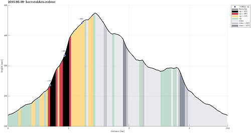
Starting from Kirsten Flagstads vei, we first went up Rosenlundveien (in the direction towards Strutsefarmen). Before actually getting to the farm, we turned left and continued steeply upwards until the street makes a larger swing to the right. There, one can leave the street and continue, first between some trees, and then under a line (telephone line?), more or less directly up towards Løvstakken. Up via a really steep path, one quickly gets to the top of Løvstakken (it took us less than 25 mins. to ascend, making about 360 height meters in this time). From the top, we descended first in the direction of Gullsteinen, before we turned right (again into the direction towards Strutsefarmen). But also this time, we did not continue all the way to the farm, but left the main path and found a connection to the path which we had taken to the top -- at a height which is well above all houses from below. Then we took the same path down that we had used up before. All in all, a short and nicely refreshing tour on Løvstakken! :-)
Useful Resources
Web page WestCoastPeaks.com provides useful information about Løvstakken.


Kommentarer