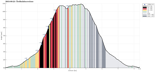
Hetta from Fyre (21.06.2015)

| Start point | E16 (310m) |
|---|---|
| Endpoint | E16 (310m) |
| Characteristic | Hillwalk |
| Duration | 4h 00min |
| Distance | 8.3km |
| Vertical meters | 894m |
| GPS |
|
| Visits of other PBEs | Fyre p-plass (325m) | 21.06.2015 |
|---|---|---|
| Hetta (1,075m) | 21.06.2015 |

Trip Summary
We left our car at the E16, right next to the bridge, which leads to Fyre. There is also a pointer towards Grindaflethytta (along a marked hiking path). Around Fyre, we first walked on a farming road, before we followed the sign that lead us to the left and up (primarily following the main path towards Grindflethytta). After a short distance, the path turns left, before it then, at about 400masl, turns right again. Exactly in this other turn, we continued northwards on what previously was a forest road (we basically walked the whole forest road in between numerous young and small trees that had started to grow on this road -- seemingly not used to often! :-)). We followed this road until it ends right next to a stream that comes down Trolladalen, separating Stalheimsnipa (on the other, northern side) and Hetta and Øvsthusnipa (on the southern side). Instead of crossing the stream at the end of the road, which possibly would have lead us to Stalheimsnipa, we ascended through the steep forest into the direction of Hetta. At times it seemed as if also others had walked there before, but then this is not clear to be sure. The ascent through the forest is really very steep and demanding (but it was very reasonable to walk -- fortunately it was dry and not slippery!). After ascending beyond the tree line, the terrain became less steep. At the same time, we started to meet so much snow that is was impossible to avoid it. We found a reasonable way up to Hetta (at about 1100masl), without a path though and via somewhat challenging terrain (partially steep, partially loose grounds, longer stretches of snow, etc.). At this small top (Hetta), we enjoyed magnificent views, before we discussed our time budget and the general conditions (lots of snow further on, etc.). We first evaluated the opportunity to cross over to ridge, which likely could have lead us down to Stalheimsnipa, but it turned out to be too dangerous, given that we not really had the gear for lots of snow and the steep terrain. Furthermore, we were unsure about the likelihood of avalanches, given the amounts of snow and the steepness of the terrain. Accordingly, we turned around and descended (more or less) the same path down that we had come up before. This was very well doable (requiring a good deal of concentrated stepping, though, in the steep terrain). Right before joining the forest road (with the young trees), we refreshed ourselves in the stream (from Trolladalen). Also the rest of the hike was basically as the path up, so we returned satisfied to our car after about 4h or hiking. All in all, a recognizably demanding hike, in partially very steep terrain, and in major parts without a path.
Photos
Selected photos are available as Google+ photo album.


User comments