Arkiv - dato
Arkiv - aktivitet
-
Annen tur (1)
- Kajakkpadling (1)
-
Annen vintertur (4)
- Trugetur (4)
- Fottur (703)
-
Skitur (3)
- Fjellskitur (3)
-
Sykkeltur (110)
- Blandet sykling (35)
- Gatesykling (5)
Arkiv - Etter geografi
"Peakbookvenner"


Lister jeg samler etter
-
Bergen ≥ 50m pf. og ≥ 100 m.o.h.
(87/89)
 97%
97% -
Most dominating tops of the Bergen peninsula
(68/75)
90%
-
Utvalgte topper og turmål i Bergen
(299/339)
88%
-
Alle topper i Bergen
(344/392)
87%
-
Opptur Bergen
(99/113)
87%
-
De syv fjell rundt Bergen
(6/7)
85%
-
Sund ≥ 50m pf.
(14/18)
77%
-
Os ≥ 50m pf.
(25/34)
73%
-
Søyler (fastmerker) i Bergen
(66/100)
66%
-
Fjell ≥ 50m pf.
(21/32)
65%

Lysehornet from Kismulvegen
- Dato:
- 07.09.2025
- Turtype:
- Fjelltur
- Turlengde:
- 4:00t
- Distanse:
- 6,9km
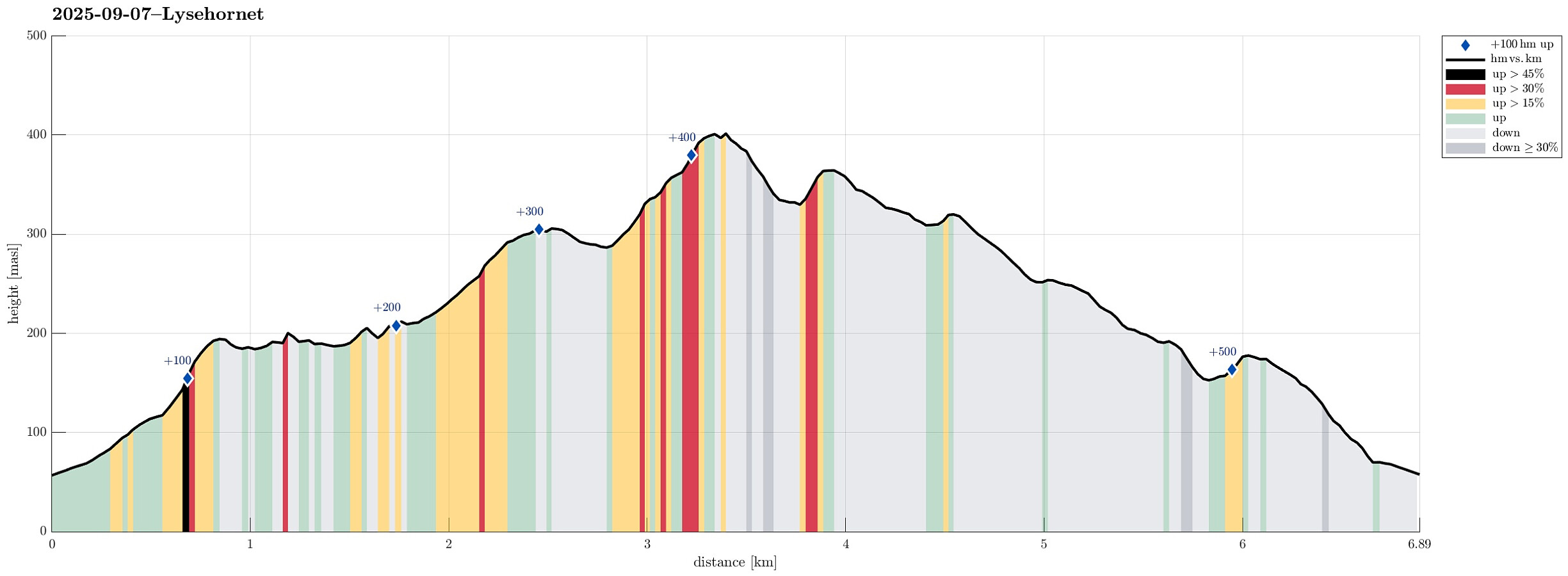 We had the idea to hike Lysehornet from the northeast (from Kismulvegen) and thus drove via Fana to Kalandsvatnet. Near house #47 along Kismulvegen, we parked -- not without an interaction with a man, who made it explicit that he'd wish us to park in Bygarasjen instead. We then started our hike into southwestern direction, first following a side-part of Kismulvegen up and towards Lindedalen. At large, the plan was to get to Lysehornet without a trail, while then taking a trail back down. After passing the upper houses (and quite a bit of rusting garbage of small to large sizes), we eventually made into the forest of Lindedalen. The first high point to reach was Hovåsen and the ascent from the northeast was a bit steep (but well doable). From Hovåsen, the plan was to hike around the >>>
Almelandsfjellet etc.
- Dato:
- 10.08.2025
- Turtype:
- Fjelltur
- Turlengde:
- 3:00t
- Distanse:
- 6,2km
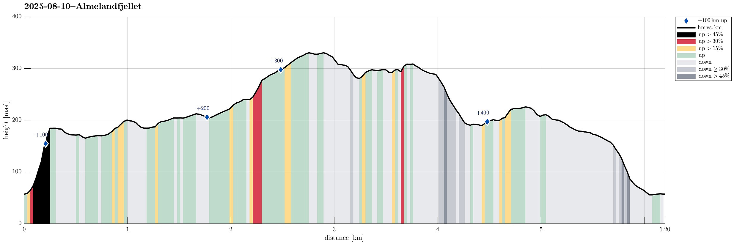 On this partially wet Sunday, the plan was to make something not too long and not too far away. Since I had not visited Smørkisfjellet before, I "cooked up" a round, starting from Osvegen near Kalandseidet. I somehow thought that I could try an ascent to Blåurskampen from the west (even though I had seen during my map study at home that this side of this hill is very steep with quite some cliffs, actually). I started from right underneath Blåurskampen and already down at Osvegen I wondered whether this really was such a good idea (it was not). I still entered the terrain and quickly found out: (a) it was wet from all the rain, (b) there was a lot of vegetation, and (c) it is truly steep -- at times way too steep there. I still continued (why?), making height meters relatively >>>
Evening visit to the Shiratani Unsui Gorge
- Dato:
- 02.07.2025
- Turtype:
- Fjelltur
- Turlengde:
- 1:00t
- Distanse:
- 3,3km
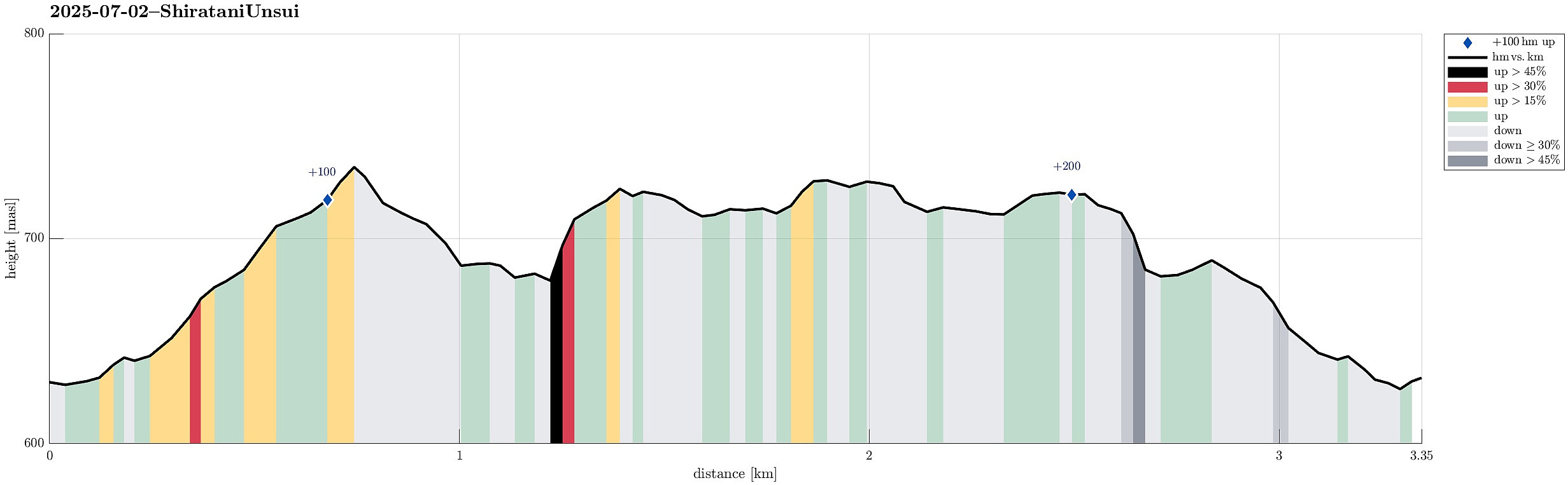 There was still a bit of daylight time left -- we thus drove up to the Shiratani Unsui Gorge to have one relatively quick look. In principle, one could start from this place to extensive hikes, but given the relatively short time left, we only walked around the gorge for short while. Clearly, experiencing the jungle in the evening is also something very special! :-)
Selected photos are available as Google photo album .
See also the related FB-page Hiking around Bergen, Norway .
There was still a bit of daylight time left -- we thus drove up to the Shiratani Unsui Gorge to have one relatively quick look. In principle, one could start from this place to extensive hikes, but given the relatively short time left, we only walked around the gorge for short while. Clearly, experiencing the jungle in the evening is also something very special! :-)
Selected photos are available as Google photo album .
See also the related FB-page Hiking around Bergen, Norway .
Visiting Kumamoto Castle
- Dato:
- 29.06.2025
- Turtype:
- Fjelltur
- Turlengde:
- 1:30t
- Distanse:
- 3,2km
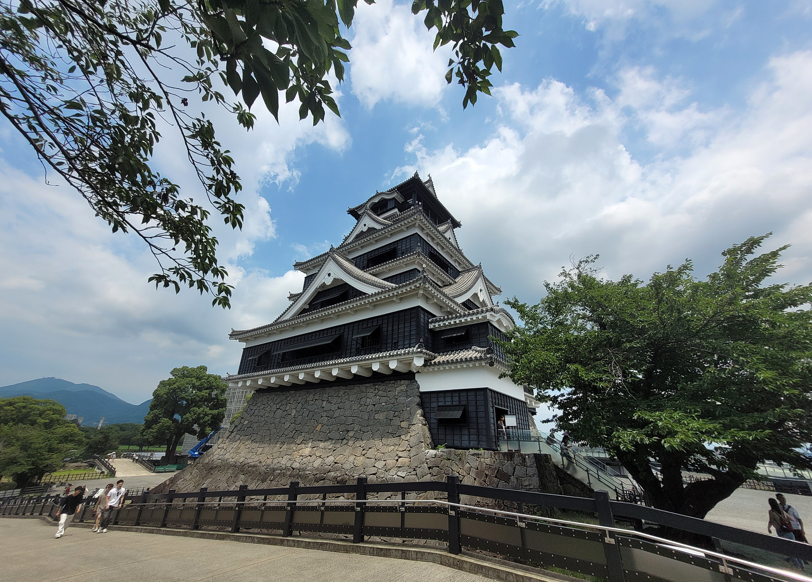 We had chosen to stay over night in Kumamoto to see Kumamoto Castle. After finding the actual entry to the castle area, we then approached it via a big bridge, which is errected to bypass major renovation work that became necessary after an earthquake had caused serious damage to multiple structure at and around the historc castle. It was possible, though, to enter the castle and to make a tour through it (with many, many others!). Eventually, we just made it back in an attempt to limit our time in the substantial heat of the day.
Selected photos are available as Google photo album .
See also the related FB-page Hiking around Bergen, Norway .
We had chosen to stay over night in Kumamoto to see Kumamoto Castle. After finding the actual entry to the castle area, we then approached it via a big bridge, which is errected to bypass major renovation work that became necessary after an earthquake had caused serious damage to multiple structure at and around the historc castle. It was possible, though, to enter the castle and to make a tour through it (with many, many others!). Eventually, we just made it back in an attempt to limit our time in the substantial heat of the day.
Selected photos are available as Google photo album .
See also the related FB-page Hiking around Bergen, Norway .
Hiking Mt. Inari with the 1000 Torii gates
- Dato:
- 23.06.2025
- Turtype:
- Fjelltur
- Turlengde:
- 3:00t
- Distanse:
- 6,8km
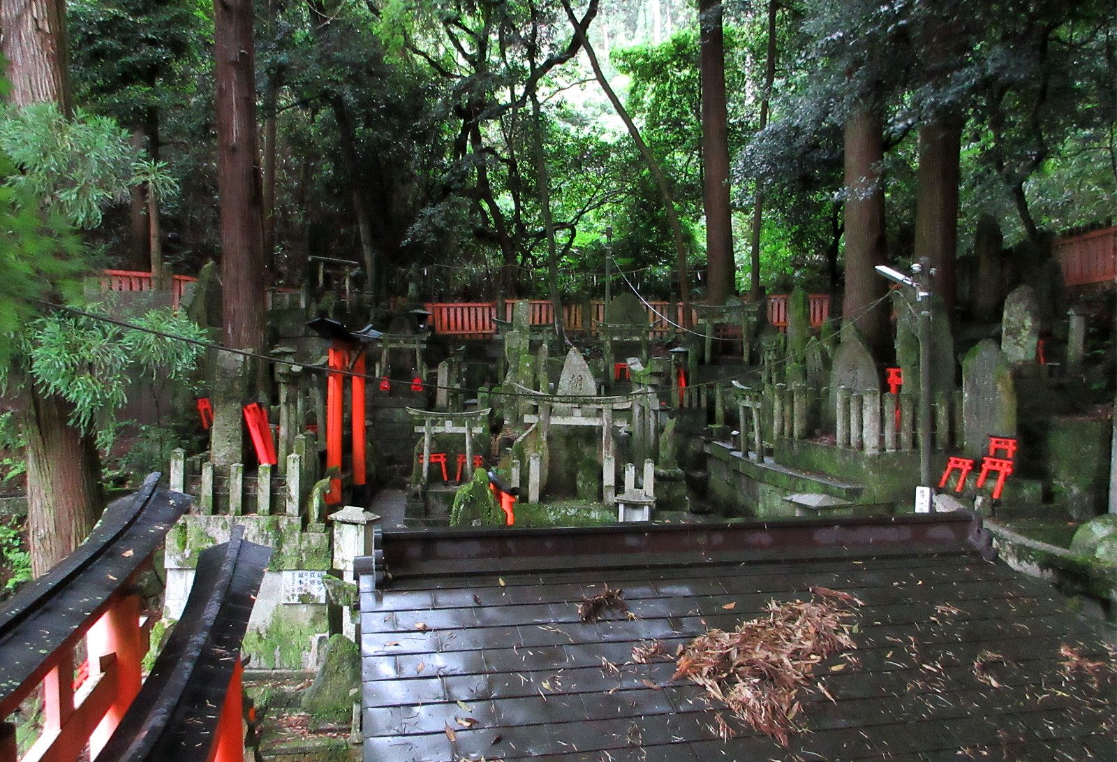 We first took a bus towards the NW of the Fushimi Inari Shrine, then walking up to the shrine (among many, many other tourists!). Further upwards, we first followed the main route, plassing through numerous red torii gates. Slightly north of Omokaru Stone, we then left the main trail, following a side-trail towards the East (Fushimi Kandakara Shrine). There, and following this minor side-trail further eastwards, we entered an amazing bamboo forest, soon later reaching an old cemetary in the woods. By that time, a thunderstorm had developed with some rain, adding to the very special atmosphere in the forest. A bit further along the trail, we then tried to find the Shiragiku waterfall, but turned around in the bamboo forest because to too many fallen bamboo trees, blocking our progress. >>>
Luxembourg (and back via the Plateau de Kirchberg)
- Dato:
- 03.06.2025
- Turtype:
- Fjelltur
- Turlengde:
- 5:00t
- Distanse:
- 9,1km
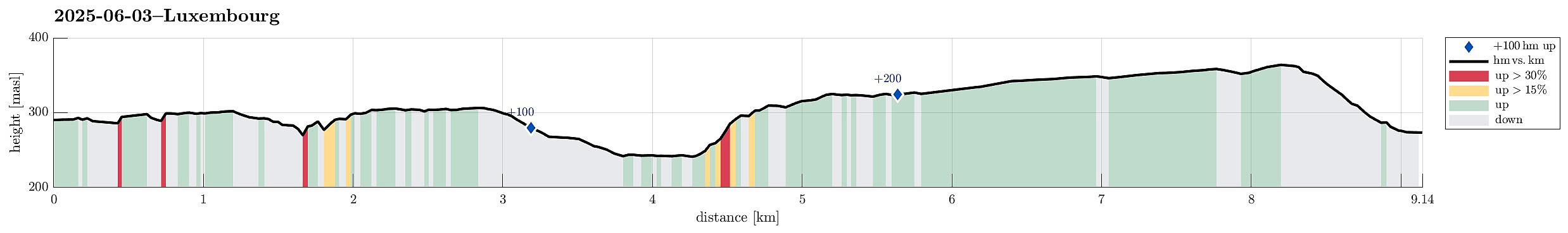 Starting with a nice and interesting guided tour through the historic city of Luxembourg, this walk was ended with a late evening return to the hotel via the Plateau de Kirchberg. Places visited: Pont Adolphe, Place de la Constitution, Chemin de la Corniche, Place Guillaume II, Place d'Armes, Montée de Clausen, Fort Obergrünewald, Fort Thüngen, Philharmonie Luxembourg, and the Plateau de Kirchberg.
Selected photos are available as Google photo album .
See also the related FB-page Hiking around Bergen, Norway .
Starting with a nice and interesting guided tour through the historic city of Luxembourg, this walk was ended with a late evening return to the hotel via the Plateau de Kirchberg. Places visited: Pont Adolphe, Place de la Constitution, Chemin de la Corniche, Place Guillaume II, Place d'Armes, Montée de Clausen, Fort Obergrünewald, Fort Thüngen, Philharmonie Luxembourg, and the Plateau de Kirchberg.
Selected photos are available as Google photo album .
See also the related FB-page Hiking around Bergen, Norway .
Luxembourg via the Plateau de Kirchberg
- Dato:
- 01.06.2025
- Turtype:
- Fjelltur
- Turlengde:
- 3:00t
- Distanse:
- 11,6km
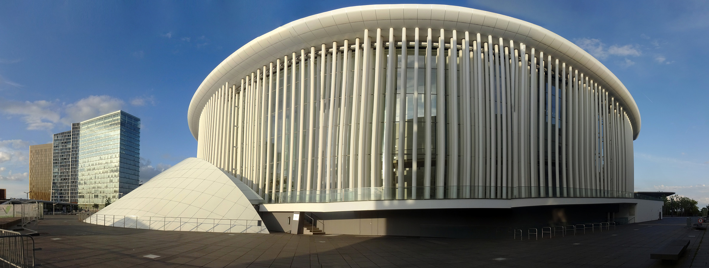 Evening walk to downtown Luxembourg. I started from Parc Hotel Alvisse and ascended first the Plateau de Kirchberg at op de Schleed. I then headed to the still relatively newly built up area at the Plateau de Kirchberg. There, I then passed by the Philharmonic Hall of Luxembourg. I then walked through the fortifications at Fort Thüngen to descend into the valley of the Alzette. On the other side, I found a way to get up to the Plateau Altmünster. From there, I used the Montée de Clausen to get into the city of Luxembourg. After walking across both the Place Guillaume II and the Place d'Armes, I then decided that it was time to head back to the hotel. Near the Rue des Bains, I got onto the Avenue de la Porte-Neuve, which I then followed until I got on the Rue des Glacis. Where this >>>
Exploring the south of Turøyna
- Dato:
- 30.05.2025
- Turtype:
- Fjelltur
- Turlengde:
- 2:00t
- Distanse:
- 5,2km
 The day was just too nice to not escape in the evening for a short exploration of the south of Turøyna. We parked near the central roundabout at Turøyna and tried to find a good entry point from Kalderasvegen to start our exploration. We first left the road prematurely and then, after getting back we tried again a few meters further in the southwest. The trail head is basically invisible from the road, but we found it anyway (at the second attempt). From there, the trail is barely visible and one quickly gets in a pretty wet forest just a few meters from the road. Navigating some minor ups and downs, we then made it to the northern ridge of a small hill south of Kalderasvegen. We then made it through another small valley to get to the next hill, a bit further to the SSW. After crossing >>>
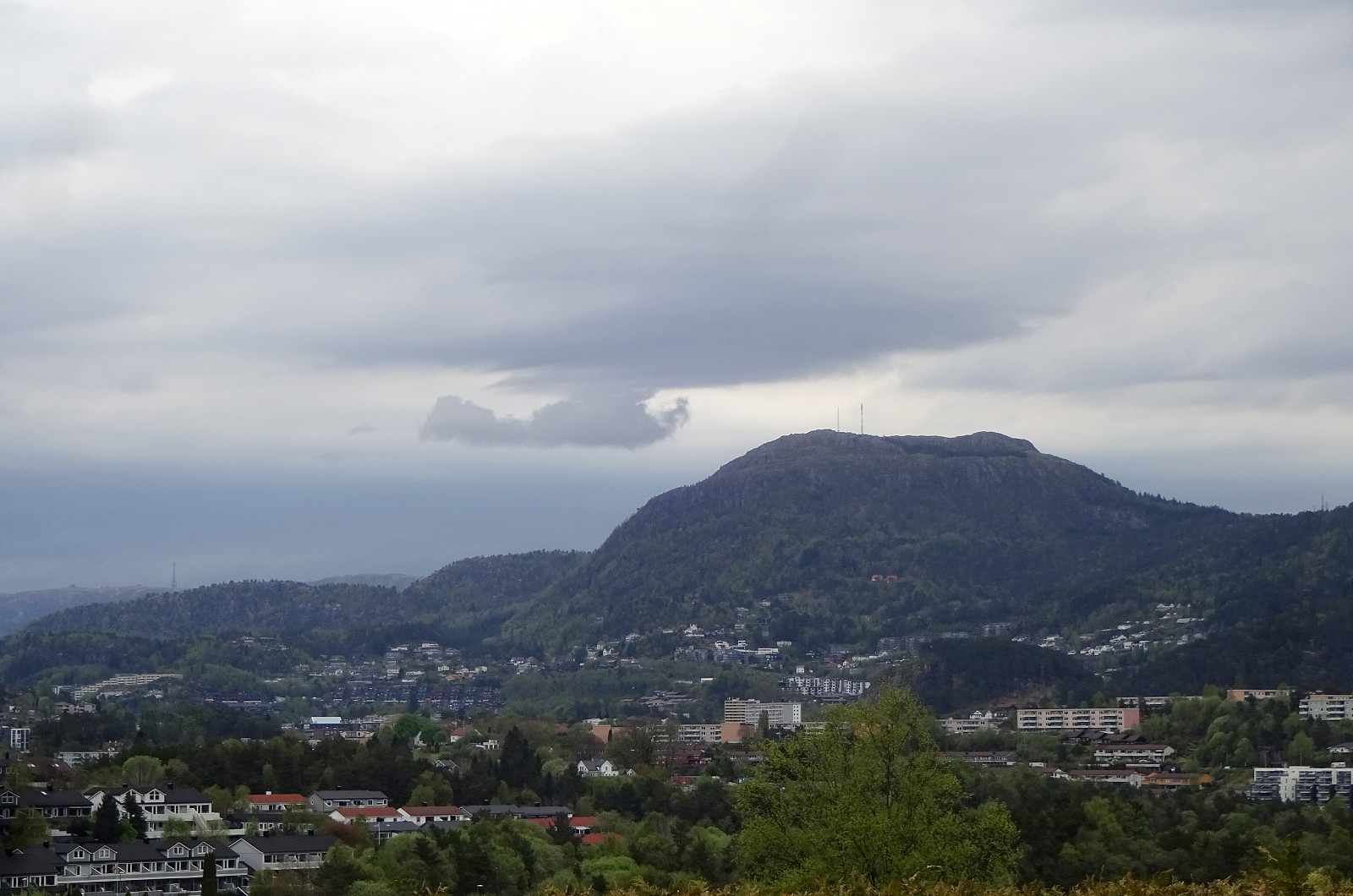
Lyderhorn
- Dato:
- 24.05.2025
- Turtype:
- Fjelltur
- Turlengde:
- 1:30t
- Distanse:
- 2,9km
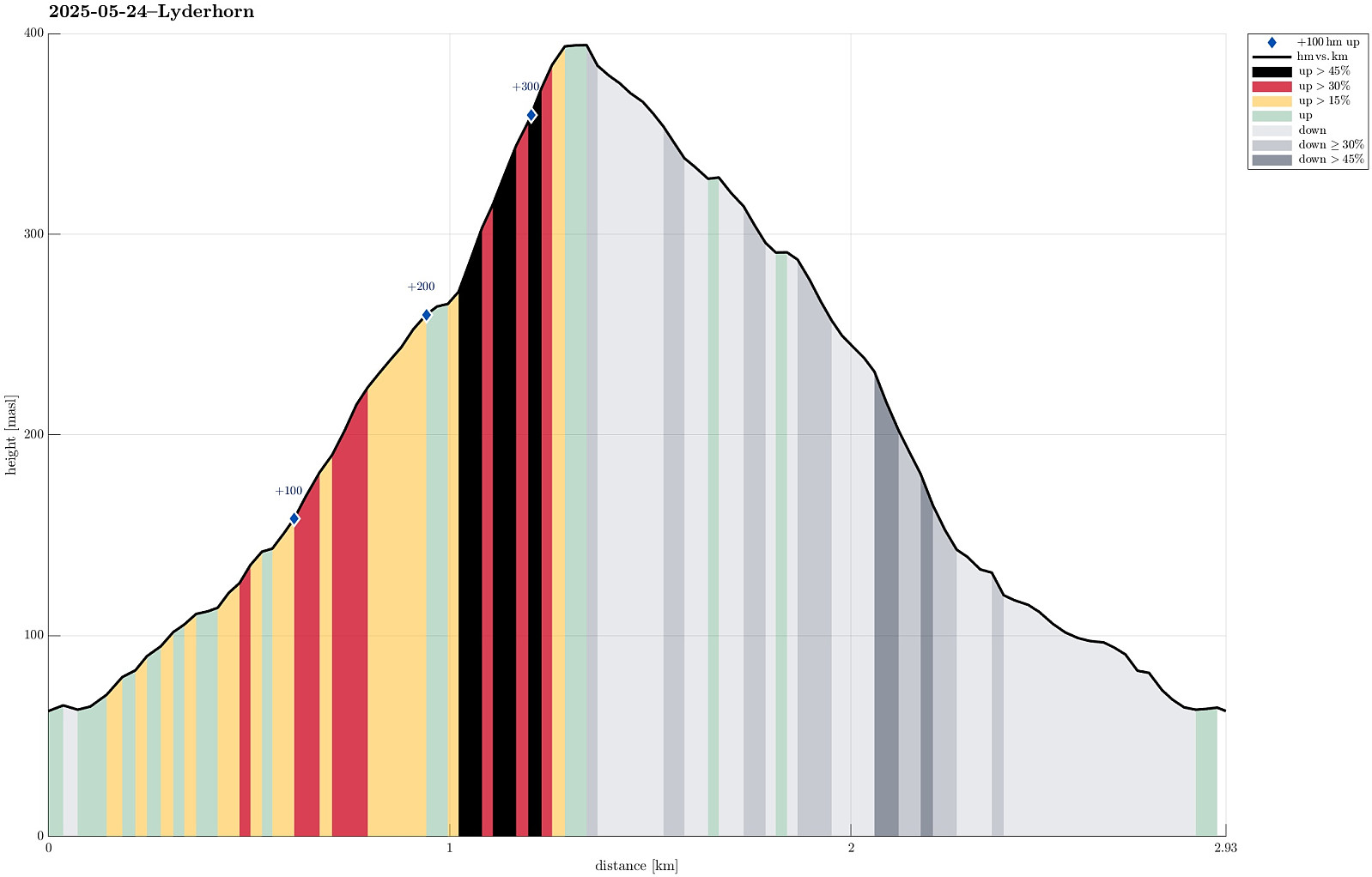 We had something like two hours available and thus aimed at "just" Lyderhorn in the neighborhood. Always nice to hike up and down this little mountain with nonetheless impressive views! :-)
Selected photos are available as Google photo album .
See also the related FB-page Hiking around Bergen, Norway .
Petter Bjørstad has a useful page about Lyderhorn and also web page WestCoastPeaks.com provides useful information about Lyderhorn and Ørnafjellet .
We had something like two hours available and thus aimed at "just" Lyderhorn in the neighborhood. Always nice to hike up and down this little mountain with nonetheless impressive views! :-)
Selected photos are available as Google photo album .
See also the related FB-page Hiking around Bergen, Norway .
Petter Bjørstad has a useful page about Lyderhorn and also web page WestCoastPeaks.com provides useful information about Lyderhorn and Ørnafjellet .
Knappen
- Dato:
- 01.05.2025
- Turtype:
- Fjelltur
- Turlengde:
- 1:00t
- Distanse:
- 4,4km
 With only little time at our hands (or feet?), we did only a quick excursion to nearby Knappen. Nice! :-)
Selected photos are available as Google photo album .
See also the related FB-page Hiking around Bergen, Norway .
With only little time at our hands (or feet?), we did only a quick excursion to nearby Knappen. Nice! :-)
Selected photos are available as Google photo album .
See also the related FB-page Hiking around Bergen, Norway .
