Archive - Date
Archive - Activity
-
Bike trip (110)
- Bike trip - mixed (35)
- Bike trip - road (5)
-
Other trip (1)
- Kayaking (1)
-
Other winter trip (4)
- Snowshoe trip (4)
- Ski trip (3)
- Trip by foot (703)
Archive - Geography
Peakbook-Friends


Collected lists
-
Bergen ≥ 50m pf. og ≥ 100 m.o.h.
(87/89)
 97%
97% -
Most dominating tops of the Bergen peninsula
(68/75)
90%
-
Utvalgte topper og turmål i Bergen
(299/339)
88%
-
Alle topper i Bergen
(344/392)
87%
-
Opptur Bergen
(99/113)
87%
-
De syv fjell rundt Bergen
(6/7)
85%
-
Sund ≥ 50m pf.
(14/18)
77%
-
Os ≥ 50m pf.
(25/34)
73%
-
Søyler (fastmerker) i Bergen
(66/100)
66%
-
Fjell ≥ 50m pf.
(21/32)
65%

Tour de Hus 5
- Date:
- 01.05.2007
- Characteristic:
- Bike trip
- Duration:
- 1:30h
- Distance:
- 31.2km
 Cycling to see some places around Bergen.
Tour de Hus 4
- Date:
- 29.04.2007
- Characteristic:
- Bike trip
- Duration:
- 2:30h
- Distance:
- 46.3km
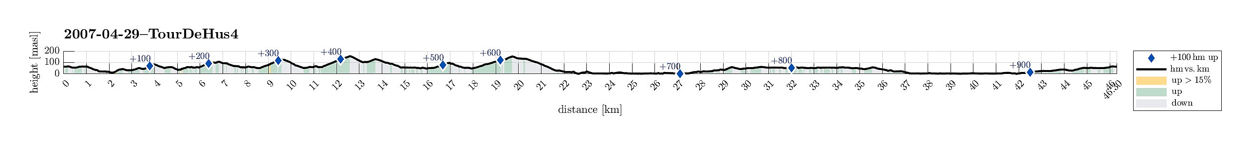 Cycling to see some places around Bergen.
Tour de Hus 3
- Date:
- 25.03.2007
- Characteristic:
- Bike trip
- Duration:
- 2:00h
- Distance:
- 39.0km
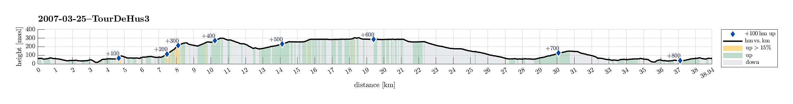 Cycling to see some places around Bergen.
Tour de Hus 2
- Date:
- 24.03.2007
- Characteristic:
- Bike trip - mixed
- Duration:
- 2:00h
- Distance:
- 32.1km
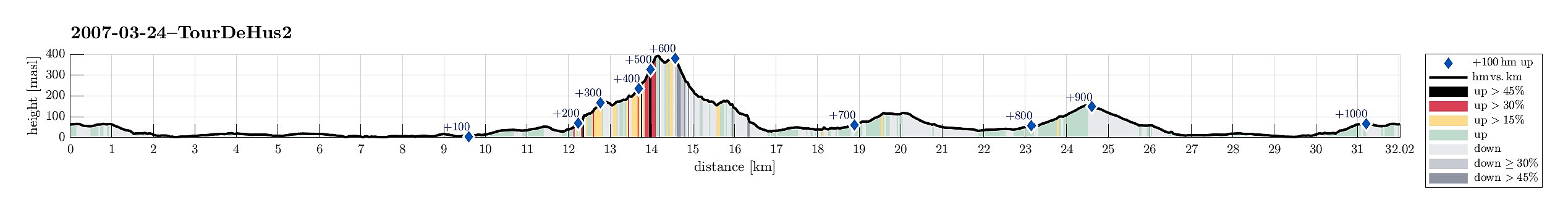 Cycling (and hiking) to see some places around Bergen.
Tour de Hus 1
- Date:
- 17.03.2007
- Characteristic:
- Bike trip
- Duration:
- 2:30h
- Distance:
- 46.7km
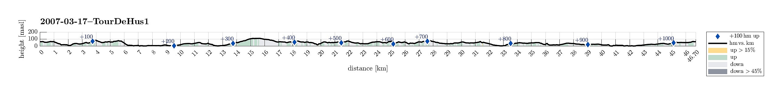 Cycling to see some places around Bergen.
Winter excursion to Höllenstein
- Date:
- 25.12.2006
- Characteristic:
- Hillwalk
- Duration:
- 3:00h
- Distance:
- 8.7km
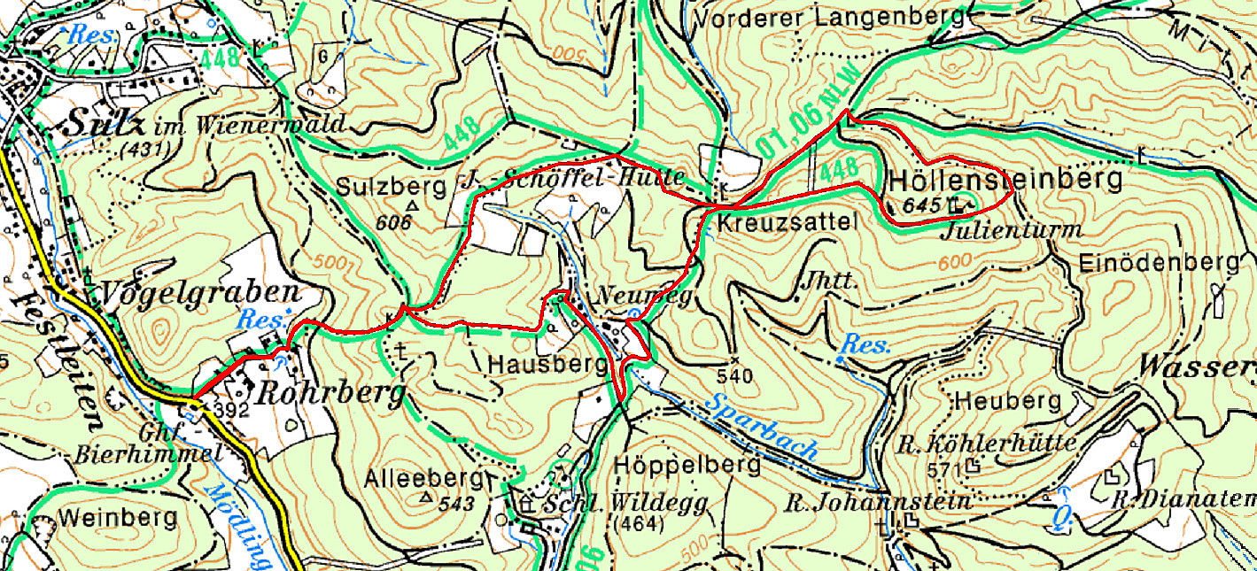 This time, we started from Rohrberg and headed eastwards towards Höllensteinberg. In nice winter weather, we ascended to the heights around J.-Schöffel-Hütte and continued via Kreuzsattel towards Höllensteinberg. Instead of directly ascending to its top right away, we first surrounded it and got up to the top from the east. We then continued in western direction, making use of some simple sledges that we had brought along (this turned out to be way more dangerous than anticipated, due to the steep descent from Höllenstein!). After having returned to Kreuzsattel, we followed the Nordalpenweg down into the direction of Sittendorf/Wildegg. Once we were down to the Sparbach, we crossed it and ascended again (via Hausberg) into order to get over and back to Rohrberg.
See also the related >>>
This time, we started from Rohrberg and headed eastwards towards Höllensteinberg. In nice winter weather, we ascended to the heights around J.-Schöffel-Hütte and continued via Kreuzsattel towards Höllensteinberg. Instead of directly ascending to its top right away, we first surrounded it and got up to the top from the east. We then continued in western direction, making use of some simple sledges that we had brought along (this turned out to be way more dangerous than anticipated, due to the steep descent from Höllenstein!). After having returned to Kreuzsattel, we followed the Nordalpenweg down into the direction of Sittendorf/Wildegg. Once we were down to the Sparbach, we crossed it and ascended again (via Hausberg) into order to get over and back to Rohrberg.
See also the related >>>
Cycling between Triesting and Piesting
- Date:
- 06.07.2006
- Characteristic:
- Bike trip
- Duration:
- 3:00h
- Distance:
- 47.1km
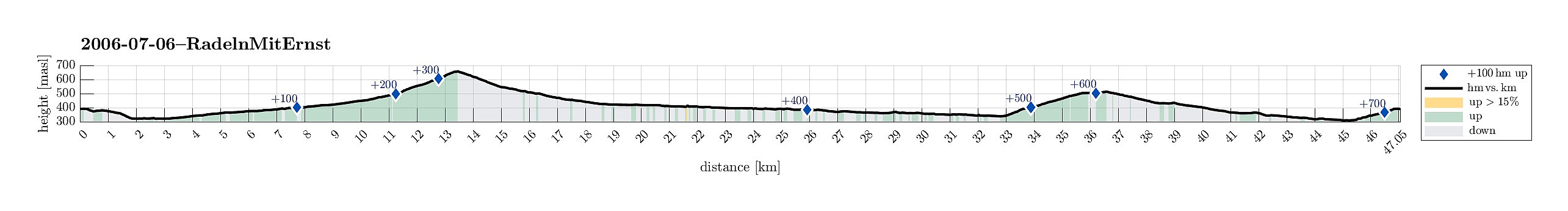 We started this bike trip near Medauhof, between Ödlitz and Berndorf. From there, we first descended towards Pottenstein an der Triesting, where we changed over to the other side of the valley. From there, we entered the long and nice Grabenweg-valley, which leads up to the saddle Am Hals at its very end. Mostly, this road is leading gently upwards, but at its very end, it becomes a little steeper and a nice challenge for cyclists, not talking here about challenges, which aggressive drivers occasionally impose on those on two wheels! On the other side of the saddle, we clearly enjoyed a longer and faster descent into the valley, which brings on out to Perniz. There, we basically turned left (into eastern direction) and followed the Piesting for quite a while on its way out of the mountains. >>>
Rax above the clouds
- Date:
- 20.11.2005
- Characteristic:
- Hike
- Duration:
- 5:00h
- Distance:
- 4.8km
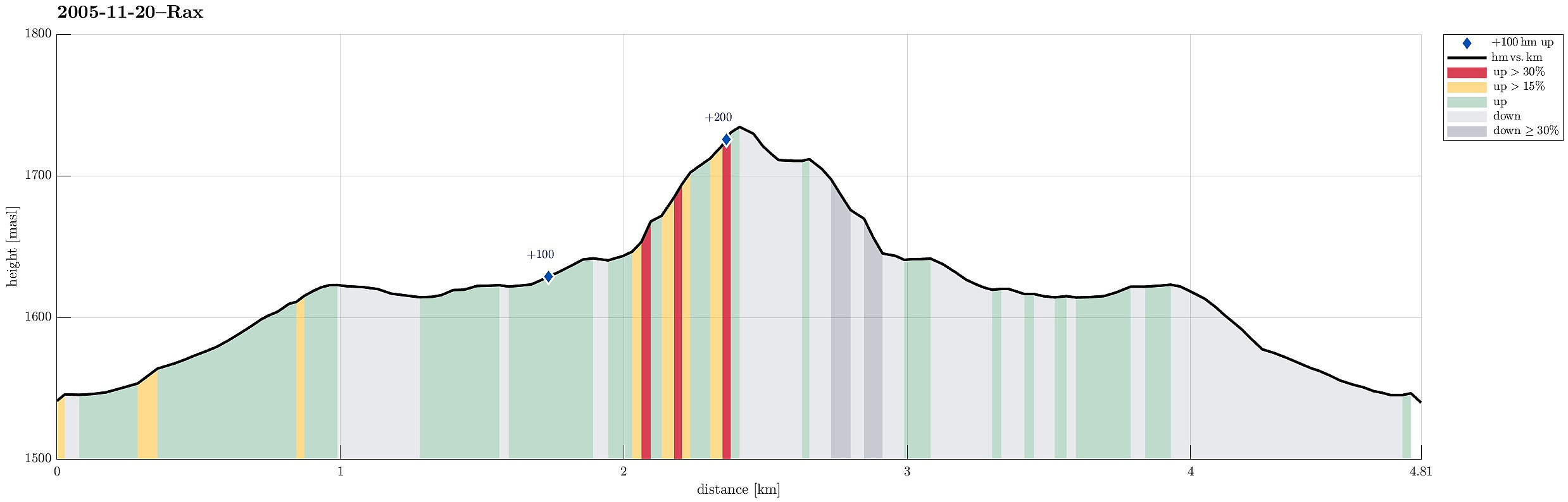 We took the cable car from Hirschwang, west of Reichenau, to get up to Rax. While the approach to the cable car was gray, wet, and cold, we really appreciated being lifted above the clouds by the cable car! Nice! :-) Above the clouds and above the tree line, we hiked across the heights of Rax to get to Ottohaus and Jakobskogel. There, we enjoyed amazing views from the upper edge of the high cliffs of Rax, overlooking an ocean of clouds beneath us. After enjoying several hours on the sunny heights, while we knew that the day in the plains was way less pleasant, we eventually returned to the cable car and back down to our car.
Selected photos are available as Google photo album .
See also the related FB-page Hiking around Bergen, Norway .
We took the cable car from Hirschwang, west of Reichenau, to get up to Rax. While the approach to the cable car was gray, wet, and cold, we really appreciated being lifted above the clouds by the cable car! Nice! :-) Above the clouds and above the tree line, we hiked across the heights of Rax to get to Ottohaus and Jakobskogel. There, we enjoyed amazing views from the upper edge of the high cliffs of Rax, overlooking an ocean of clouds beneath us. After enjoying several hours on the sunny heights, while we knew that the day in the plains was way less pleasant, we eventually returned to the cable car and back down to our car.
Selected photos are available as Google photo album .
See also the related FB-page Hiking around Bergen, Norway .
Höllenstein
- Date:
- 29.10.2005
- Characteristic:
- Hillwalk
- Duration:
- 4:00h
- Distance:
- 6.8km
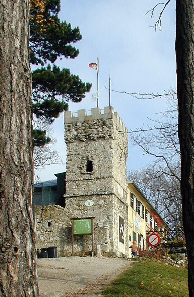 We started near Sittendorf (on Wildeggerstrasse) and started with an ascent into northwestern direction, passing by Alleeberg in the beginning. We then connected to the Mödlinger Rundwanderweg (via some nice heights), before we ascended to the Höllenstein as the top-goal of this day. From there, we first followed the path back which we had taken there, until we met the Nordalpenweg, which we then took down to get back to where we had started.
See also the related FB-page Hiking around Bergen, Norway .
We started near Sittendorf (on Wildeggerstrasse) and started with an ascent into northwestern direction, passing by Alleeberg in the beginning. We then connected to the Mödlinger Rundwanderweg (via some nice heights), before we ascended to the Höllenstein as the top-goal of this day. From there, we first followed the path back which we had taken there, until we met the Nordalpenweg, which we then took down to get back to where we had started.
See also the related FB-page Hiking around Bergen, Norway .
Across the Ebenwaldhoehe to Schwarzwaldeck
- Date:
- 26.10.2005
- Characteristic:
- Hike
- Duration:
- 4:00h
- Distance:
- 4.7km
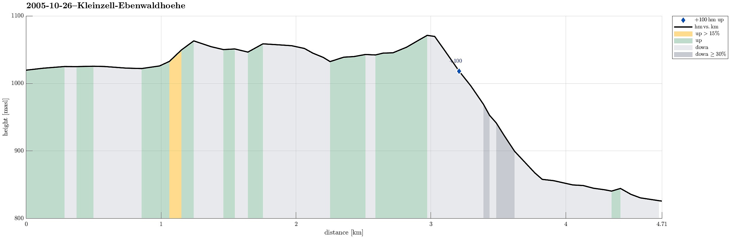 On this autumn day, we decided to make a hike in the height. From Kleinzell, we took the road up to Ebenwald, where we started our hike already above 1000mosl. Most of the hike was then pretty much on the same height until we arrived at Schwarzwaldeck at 1077mosl. From there, we then descended comparably steeply until we arrived at a place serving food and drinks, right next to the road.
See also the related FB-page Hiking around Bergen, Norway .
On this autumn day, we decided to make a hike in the height. From Kleinzell, we took the road up to Ebenwald, where we started our hike already above 1000mosl. Most of the hike was then pretty much on the same height until we arrived at Schwarzwaldeck at 1077mosl. From there, we then descended comparably steeply until we arrived at a place serving food and drinks, right next to the road.
See also the related FB-page Hiking around Bergen, Norway .
