Archiv - Nach Datum
Archiv - Nach Aktivität
-
Andere Tour (1)
- Kayaking (1)
-
Andere Wintertour (4)
- Schneeschuhtour (4)
-
Fahrradtour (110)
- Fahrradtour Straße (5)
- Fahrradtour gemischt (35)
-
Fußtour (703)
- Bergtour (351)
- Jogging (18)
- Spaziergang (83)
- Wanderung (251)
-
Skitour (3)
- Tourenskilauf (3)
Archiv - Nach Geografie
Peakbookfreunde


Gesammelte Listen
-
Bergen ≥ 50m pf. og ≥ 100 m.o.h.
(87/89)
 97%
97% -
Most dominating tops of the Bergen peninsula
(68/75)
90%
-
Utvalgte topper og turmål i Bergen
(299/339)
88%
-
Alle topper i Bergen
(344/392)
87%
-
Opptur Bergen
(99/113)
87%
-
De syv fjell rundt Bergen
(6/7)
85%
-
Sund ≥ 50m pf.
(14/18)
77%
-
Os ≥ 50m pf.
(25/34)
73%
-
Søyler (fastmerker) i Bergen
(66/100)
66%
-
Fjell ≥ 50m pf.
(21/32)
65%

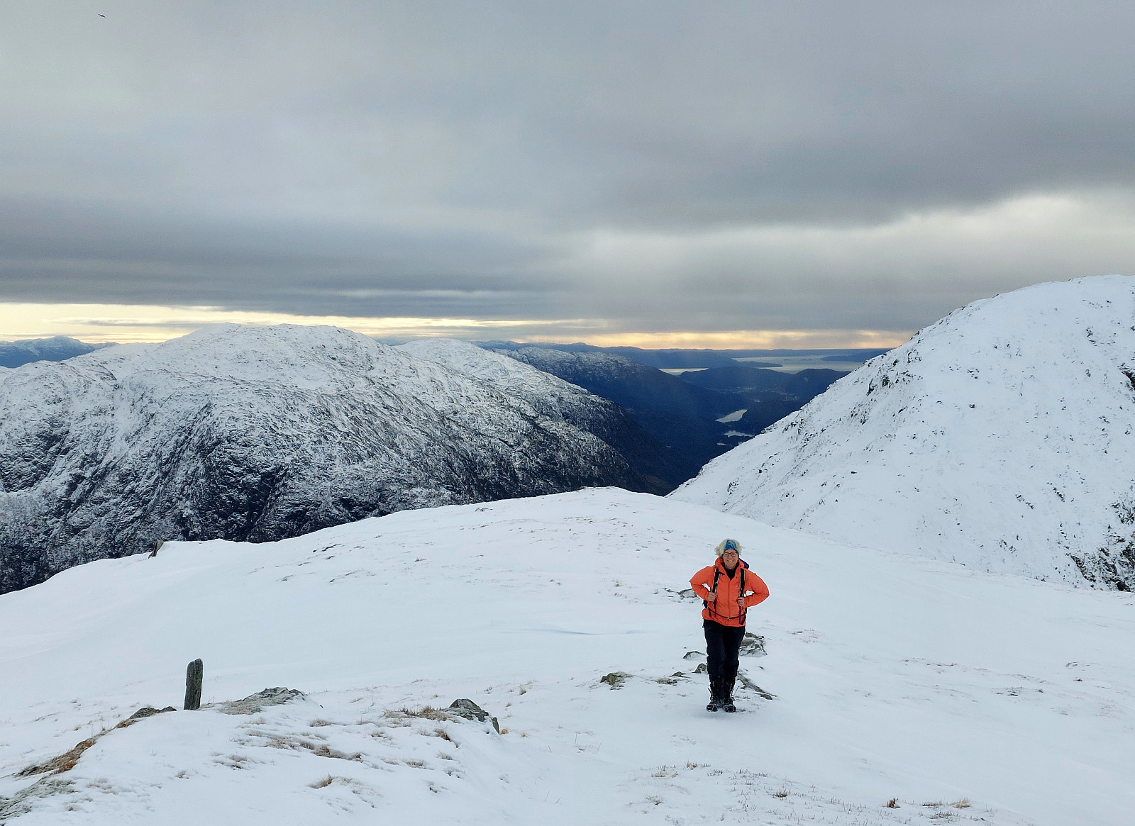
Hananipa
- Datum:
- 09.02.2025
- Tourcharakter:
- Wanderung
- Tourlänge:
- 3:00h
- Entfernung:
- 6,5km
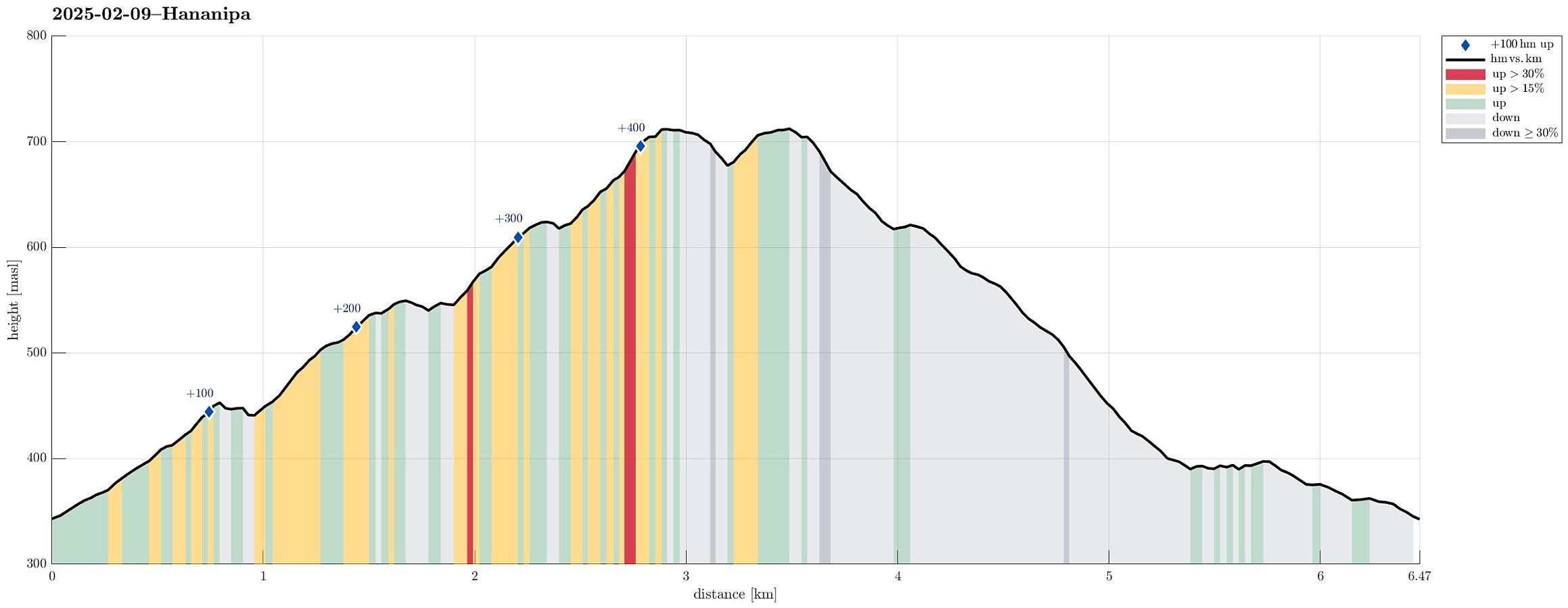 We expected a nice day and tought that Hananipa would be a nice goal. In fact, we tought that making a nice round, including Raudnipa and/or Trollabotsvarden, would be a good idea. We drove out of Bergen into the direction of Voss and left road E16 at Trengereid to drive up to Nordre Skulstad. There, we parked and started our hike by heading towards Geitshushaugen, first, and then further up to Åsen, before connecting to Brunane. After following Brunane all the way up, we then continued up to Hananipa via its western ridge. Already at home, we had talked about the slightly steep section from Hananipa down to Sauaskaret; when then stepping towards this section, we concluded that we did not feel safe enough (with all the snow etc.). We thus turned around and headed back down the western >>>
Hausdalshorgi via Edne from Hausdalen
- Datum:
- 01.02.2025
- Tourcharakter:
- Wanderung
- Tourlänge:
- 5:00h
- Entfernung:
- 10,8km
 On the map, we had started wondering whether it should not be alright to ascend to Hausdalshorgi from Hausdalen. With some over-optimistic hopes for some sun, we headed into Hausdalen and parked at the very end of the road, where we often would start to hike into Brekkedalen. The idea was to walk a short stretch further up Hausdalen, before then aiming at a ridge in the south of Hausdalshorgi with the name of Edne on it on the map. East of Langhaugen, where a stream comes down from Hausdalshorgi, we then left the main trail, which leads further into Hausdalen, seeing where it would be best to get up to the targeted ridge. After crossing the stream, we saw with some positive surprise that quite obviously this place was used to get higher up the hillside long before us, already (while no >>>
Lauvåsen in Jordalen
- Datum:
- 19.01.2025
- Tourcharakter:
- Fahrradtour gemischt
- Tourlänge:
- 5:00h
- Entfernung:
- 54,0km
 We had discussed a possible hike up to Storsåta, northeast of Jordalen. The first qualification that happened was our decision to approach Jordalen with our bikes. All this worked nicely and smoothely, using the bike-tunnel between Fyllingsdalen and Minde. The next qualification then was to cross over to Munkebotn via Fløyfjellet. After checking out two options to do so that did not work out (at Lappen and Knatten we read that cycling is not allowed on Søre Kamvei!), we took a route up from Skansemyren. Passing by Skomakerdiket, we then quickly crossed over Fløyfjellet before making it further to Storevatnet and then further down to Munkebotn (the descent from Fløyfjellet down to Munkebotn is quite steep, though). At Munkebotsvatnet, we made a short break to enjoy our packed lunch. >>>
Storhelleren/Bjørndalshelleren
- Datum:
- 18.01.2025
- Tourcharakter:
- Fahrradtour gemischt
- Tourlänge:
- 2:30h
- Entfernung:
- 17,1km
 Given a rather wet winter day, we decided to explore a place, which we had on our radar for a while, already: Storhelleren/Bjørndalshelleren near Loddefjord. To add a bit to this plan, we decided to combine this excursion with a bike-trip there and back. After first cycling north on Bjørgeveien into the direction of Loddefjord, we chose to cross the bridge at Hetlevikstraumen and continue to Loddefjord on the west-side of Bjørndalspollen. At Loddefjord, we once again ended up in this dead-end loop for pedestrians at the north end of Bjørndalspollen (without any reasonable option to cross the road over to Loddefjord -- what a city planning mistake?!!). After quickly looping back, we made it onto the road and thus further northwards to the access road for the transformer at Grøvledalen. >>>
Storhovden with snow shoes
- Datum:
- 04.01.2025
- Tourcharakter:
- Schneeschuhtour
- Tourlänge:
- 3:00h
- Entfernung:
- 6,4km
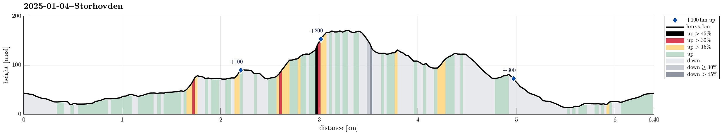 With quite a bit of snow around, still, we thought that it was the right day for taking our snow shoes out and into Kanadaskogen! From Varden, we first headed to Hesjaholten, where we put on the snow shoes. After stepping up (and around) Litla Krokatjørna, we crossed a hill to connect to Stora Krokatjørna. There, we decided to also include a visit to Storhovden (via Syningen). After a short round on the heights of Storhovden, we started our walk back. To round this excursion, we aimed at Langaheia via Spelhaugen. Always fun to venture into deep snow with snow shoes, but not easy-going to make many kilometers under such circumstances! :-)
Selected photos are available as Google photo album .
See also the related FB-page Hiking around Bergen, Norway .
With quite a bit of snow around, still, we thought that it was the right day for taking our snow shoes out and into Kanadaskogen! From Varden, we first headed to Hesjaholten, where we put on the snow shoes. After stepping up (and around) Litla Krokatjørna, we crossed a hill to connect to Stora Krokatjørna. There, we decided to also include a visit to Storhovden (via Syningen). After a short round on the heights of Storhovden, we started our walk back. To round this excursion, we aimed at Langaheia via Spelhaugen. Always fun to venture into deep snow with snow shoes, but not easy-going to make many kilometers under such circumstances! :-)
Selected photos are available as Google photo album .
See also the related FB-page Hiking around Bergen, Norway .
Stroll through snow and sun around Bjørndalsvatnet
- Datum:
- 01.01.2025
- Tourcharakter:
- Bergtour
- Tourlänge:
- 2:30h
- Entfernung:
- 8,2km
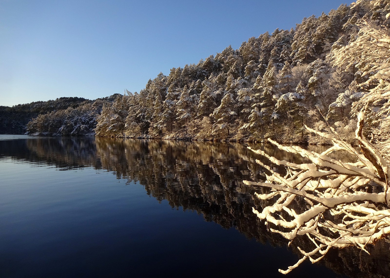 A snowy day with nice weather: a good reason for making a stroll in the neighborhood! We started with Eldtona on Knappefjellet before "turning around" and heading northwards to make a round around Bjørndalsvatnet before returning back to Varden. Not a very long hike, but very nice with the snow and some sun, also! :-)
Selected photos are available as Google photo album .
See also the related FB-page Hiking around Bergen, Norway .
A snowy day with nice weather: a good reason for making a stroll in the neighborhood! We started with Eldtona on Knappefjellet before "turning around" and heading northwards to make a round around Bjørndalsvatnet before returning back to Varden. Not a very long hike, but very nice with the snow and some sun, also! :-)
Selected photos are available as Google photo album .
See also the related FB-page Hiking around Bergen, Norway .
Løvstakken and Løvstien
- Datum:
- 30.12.2024
- Tourcharakter:
- Wanderung
- Tourlänge:
- 3:00h
- Entfernung:
- 8,8km
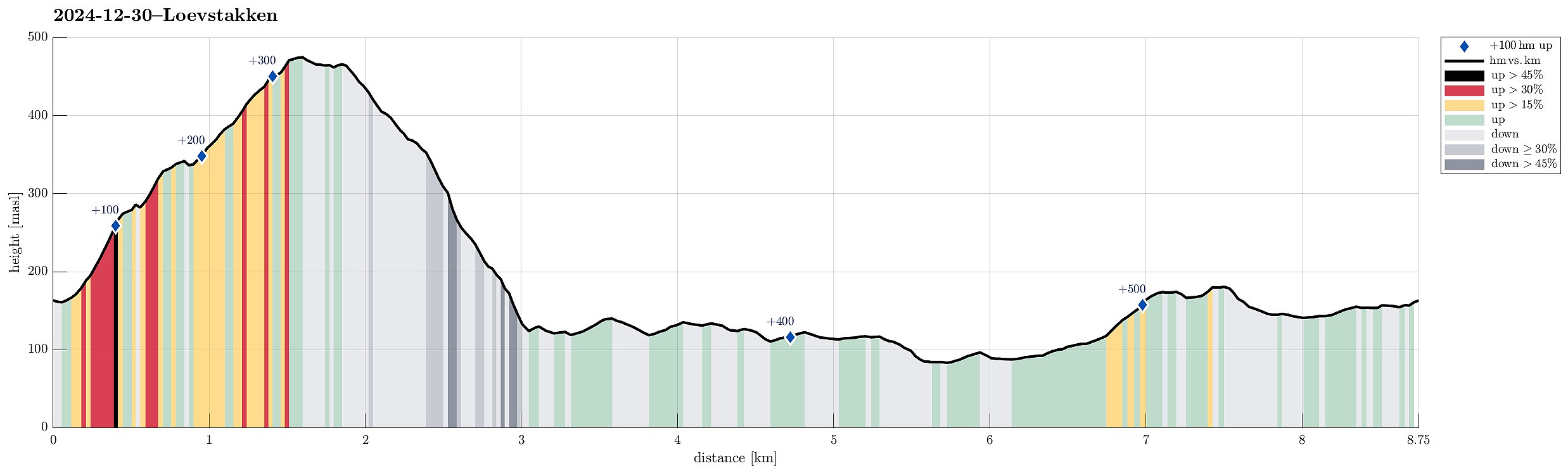 Together with friends, we had decided to use the afternoon for a short hike in the local area. We parked in the east of Litlavatnet in the northeast of Fyllingsdalen and headed up to Løvstakken following the main trail from the parking place. From the top of Løvstakken, we then descended towards the southeast using a minor trail a bit further east than the main trail in the south of Løvstakken. This brought us down to Løvstien, which we then followed (in northern direction) to complete a round back to Fyllingsdalen. Our timing was just right to cross over Løvstakken without any need for head lights -- down on Løvstien, we then took advantage of the installed lights. At the end of the hike, it started to snow, adding a nice touch to the overall experience! :-)
Selected photos are available >>>
Together with friends, we had decided to use the afternoon for a short hike in the local area. We parked in the east of Litlavatnet in the northeast of Fyllingsdalen and headed up to Løvstakken following the main trail from the parking place. From the top of Løvstakken, we then descended towards the southeast using a minor trail a bit further east than the main trail in the south of Løvstakken. This brought us down to Løvstien, which we then followed (in northern direction) to complete a round back to Fyllingsdalen. Our timing was just right to cross over Løvstakken without any need for head lights -- down on Løvstien, we then took advantage of the installed lights. At the end of the hike, it started to snow, adding a nice touch to the overall experience! :-)
Selected photos are available >>>
Straumsåsen
- Datum:
- 29.12.2024
- Tourcharakter:
- Spaziergang
- Tourlänge:
- 1:30h
- Entfernung:
- 6,3km
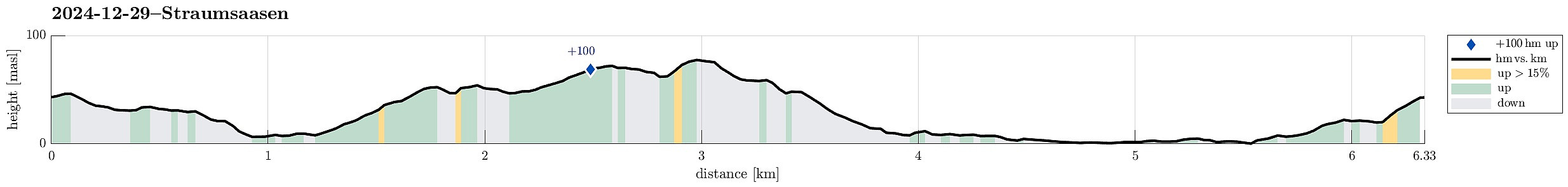 We just wished to get some fresh air and thus headed for a short walk in the neighborhood.
See also the related FB-page Hiking around Bergen, Norway .
We just wished to get some fresh air and thus headed for a short walk in the neighborhood.
See also the related FB-page Hiking around Bergen, Norway .
Kyrkjenibben etc.
- Datum:
- 23.12.2024
- Tourcharakter:
- Wanderung
- Tourlänge:
- 3:00h
- Entfernung:
- 8,4km
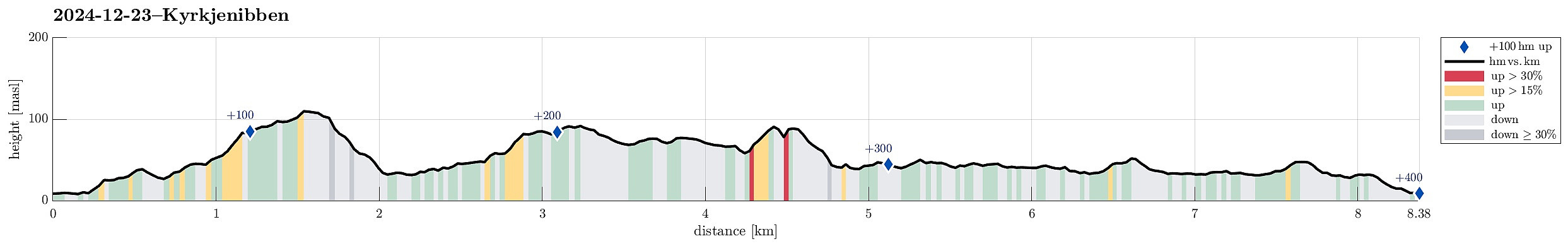 We expected the higher tops to be covered with clouds and thus decided to instead head towards the coast for a simple hike. We knew that one should be able to find a historic connection between Morland and Fjell, kyrkjevegen, which apparently was used by the people of Morland to get to the church in Fjell previously. We started near the church in Fjell and followed kyrkjevegen until we came to the south end of Eidesvatnet. Instead of following kyrkjevegen further northwards from there, we had already decided that we wished to include a detour to Gardafjellet a bit further west. Following a trail around Kvernhaugen (around the south of Liavatnet) brought us to the trail up to Gardafjellet (in northwestern direction). At Gardafjellet we enjoyed some nice views, before continuing -- then >>>
Nice round around Korsneset
- Datum:
- 08.12.2024
- Tourcharakter:
- Wanderung
- Tourlänge:
- 2:30h
- Entfernung:
- 5,5km
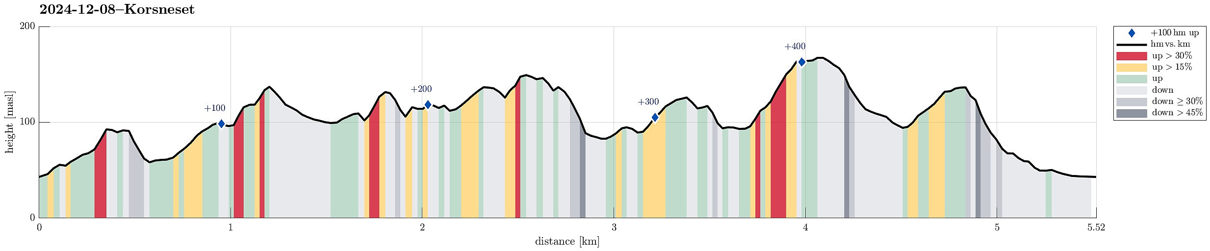 The weather was looking good for this Sunday and so we aimed at getting some fresh air around our heads. We headed via Fana to Korsneset and parked at the parking place right at the entry to the military area. Our first goal was Hendershaugen in the south of the road. To get there, we first walked the road back a few meters, before then heading towards the top of Hendershaugen along the outer rim of the military area. Even though Hendershaugen is not very high, it's still nice to get up there and enjoy some nice views. From Henderhaugen, we then headed northwards. More or less right where we stepped out of the forest and onto Korsnesvegen, we decided to continue northwards via the eastern heights of Korsneset (instead of walking back to the parking place). Within a few minutes, we were >>>
