Archive - Date
Archive - Activity
-
Bike trip (108)
- Bike trip - mixed (25)
- Bike trip - road (83)
-
Drive (9)
- Car drive (9)
-
Other trip (3)
- Kayaking (3)
-
Ski trip (109)
- Backcountry skiing (65)
- Cross-country skiing (44)
- Trip by foot (1782)
Collected lists
-
Voss ≥ 100m pf.
(96/98)
 97%
97% -
Opptur Hordaland
(143/159)
89%
-
Stasjoner på Bergensbanen
(31/40)
77%
-
Ulvik ≥ 100m pf.
(28/38)
73%
-
Hordaland ≥ 100m pf.
(613/863)
71%
-
Mjølfjell PF > 100m
(21/31)
67%
-
Jondal ≥ 100m pf.
(15/23)
65%
-
Sunnhordland PF >= 100m
(104/186)
55%
-
Dagsturhyttene i Vestland
(33/61)
54%
-
Hordaland: Hardanger PF>=100m
(186/359)
51%
-
Kvinnherad ≥ 100m pf.
(40/79)
50%
-
DNT-hytter i Hordaland
(22/45)
48%
-
Sogndal ≥ 100m pf.
(23/81)
28%
-
Vik i Sogn ≥ 100m pf.
(8/46)
17%
-
DNT-hytter i Sogn og Fjordane
(8/47)
17%
-
Eidfjord ≥ 100m pf.
(7/42)
16%
-
Etne ≥ 100m pf.
(7/51)
13%
-
Ullensvang ≥ 100m pf.
(21/153)
13%
-
Sogn - Sør for Sognefjorden PF>=100m
(17/159)
10%
-
Opptur i Sogn og Fjordane peaks
(17/177)
9%

Kviturhytten
- Date:
- 24.05.2020
- Characteristic:
- Hillwalk
- Duration:
- 2:17h
- Distance:
- 7.3km
 Warning: This hike includes off-trail scrambling in steep terrain. Consider the track with care!
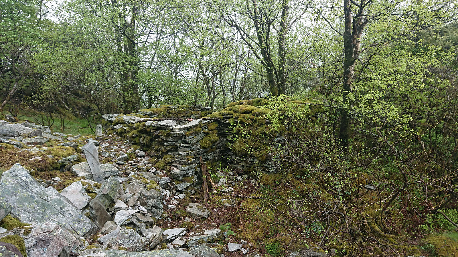
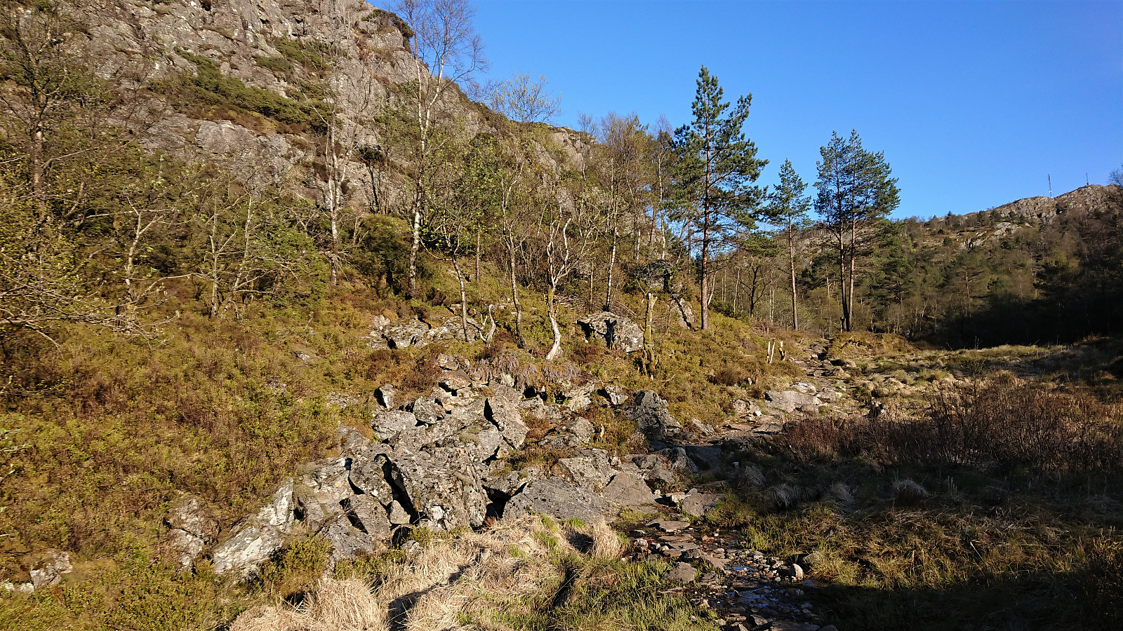
The last cabin ruin in Bergensernes Fjellverden II (BF II) in the area from Sandviksfjellet to Ulriken was what the book refers to as Kviturhytten . After finally locating it on the map, I set out from Årstadveien and followed the road along Svartediket until reaching Kviturbekken. Here I left the road on what almost looked like a trail, following the stream north.
Soon the trail however pretty much disappeared and I was left finding my own way up the steep ascent, with only some deer tracks for guidance. More scrambling than hiking, and with lots of loose small to medium size rocks. There was no real problem making progress though, as long as one was careful.
There was a lot more left of the cabin than expected, >>>
Warning: This hike includes off-trail scrambling in steep terrain. Consider the track with care!
The last cabin ruin in Bergensernes Fjellverden II (BF II) in the area from Sandviksfjellet to Ulriken was what the book refers to as Kviturhytten . After finally locating it on the map, I set out from Årstadveien and followed the road along Svartediket until reaching Kviturbekken. Here I left the road on what almost looked like a trail, following the stream north.
Soon the trail however pretty much disappeared and I was left finding my own way up the steep ascent, with only some deer tracks for guidance. More scrambling than hiking, and with lots of loose small to medium size rocks. There was no real problem making progress though, as long as one was careful.
There was a lot more left of the cabin than expected, >>>
Ørneberget, Rognåsen and Håmanen
- Date:
- 23.05.2020
- Characteristic:
- Hillwalk
- Duration:
- 1:53h
- Distance:
- 8.4km
 Local hike in strong winds.
Kannikenuten from Vevatne
- Date:
- 21.05.2020
- Characteristic:
- Hillwalk
- Duration:
- 1:19h
- Distance:
- 3.4km
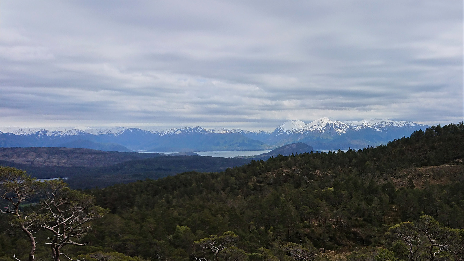
 Leaving my bike at the start of the steep tractor road up from Vevatne, I started my ascent to Kannikenuten on foot. Shortly before reaching the top of the valley, a marked trail headed northwest towards the summit. Or at least the first part was marked, but after that it was not really needed anyway. (Note that my GPS decided to take a break on the ascent. Please see the descent route for the actual trail.)
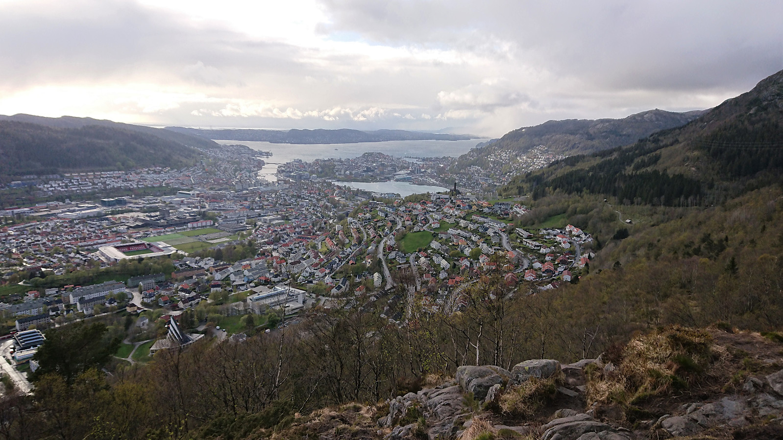
The summit provided spectacular views in almost all directions. Very unusual for a summit only 376 meters above sea level. After enjoying the views, I followed the same route back to my bike. In summary, a short nice hike that can be very highly recommended.
All that remained was now the long bike ride back home. For more on that please see: Cycling: Tuvefjellet and Kannikenuten .
Note that if arriving by car, there is no parking >>>
Leaving my bike at the start of the steep tractor road up from Vevatne, I started my ascent to Kannikenuten on foot. Shortly before reaching the top of the valley, a marked trail headed northwest towards the summit. Or at least the first part was marked, but after that it was not really needed anyway. (Note that my GPS decided to take a break on the ascent. Please see the descent route for the actual trail.)
The summit provided spectacular views in almost all directions. Very unusual for a summit only 376 meters above sea level. After enjoying the views, I followed the same route back to my bike. In summary, a short nice hike that can be very highly recommended.
All that remained was now the long bike ride back home. For more on that please see: Cycling: Tuvefjellet and Kannikenuten .
Note that if arriving by car, there is no parking >>>
Tuvefjellet via Kyrkjefjellet
- Date:
- 21.05.2020
- Characteristic:
- Hillwalk
- Duration:
- 1:40h
- Distance:
- 5.2km
 After finally arriving at the parking lot and the tractor road indicating the start of the unmarked trail towards Kyrkjefjellet , I quickly left my bike behind and continued on foot. When the tractor road ended, I easily followed the trail all the way to the viewpoint southwest of the summit of Kyrkjefjellet , referred to as "Benk 1" (i.e. "Bench 1"), which provided spectacular views towards the west. The views from the summit itself were more limited.
So far the trail had been unmarked, but when continuing east, lots of red trail markers suddenly started appearing, marking a trail that could be followed almost all the way to the viewpoint southwest of the summit of Tuvefjellet , referred to as "Benk 2". The red markers continued east from the bench, but did not pass by the summit itself. It was however straightforward to reach the summit from the trail.
The best views were not obtained from south of the >>>
After finally arriving at the parking lot and the tractor road indicating the start of the unmarked trail towards Kyrkjefjellet , I quickly left my bike behind and continued on foot. When the tractor road ended, I easily followed the trail all the way to the viewpoint southwest of the summit of Kyrkjefjellet , referred to as "Benk 1" (i.e. "Bench 1"), which provided spectacular views towards the west. The views from the summit itself were more limited.
So far the trail had been unmarked, but when continuing east, lots of red trail markers suddenly started appearing, marking a trail that could be followed almost all the way to the viewpoint southwest of the summit of Tuvefjellet , referred to as "Benk 2". The red markers continued east from the bench, but did not pass by the summit itself. It was however straightforward to reach the summit from the trail.
The best views were not obtained from south of the >>>
Cabin ruins: Løvstakken
- Date:
- 20.05.2020
- Characteristic:
- Hillwalk
- Duration:
- 3:40h
- Distance:
- 12.1km
 Yet another hike to search for old cabin ruins. This time in what was used to be called Hyttelien, an area south of Løvstakken were there once used to be numerous cabins, none of which are still standing. Once again I could benefit from knutsverre (Knut S. Andersen) 's excellent work for locating most of the ruins in the area. There were however two ruins that he had struggled to find: Helgheim and Gyldenprishytten/Akevitten . For the former, I was pretty sure I had found its location via in-depth inspection of old aerial photos, but for the latter I had not been able to find any additional information prior to the hike.
After first visiting Knut Sverre’s suggested locations for Gyldenprishytten and Helgheim (now renamed Tuft NV for Liafjellet, Løvstakken and Tuft V for Liafjellet, Løvstakken , I made a quick visit to the summit of the newly added Liafjellet , including a surprisingly steep descent, before heading towards the ruins of Fagerheim .
Upon >>>
Yet another hike to search for old cabin ruins. This time in what was used to be called Hyttelien, an area south of Løvstakken were there once used to be numerous cabins, none of which are still standing. Once again I could benefit from knutsverre (Knut S. Andersen) 's excellent work for locating most of the ruins in the area. There were however two ruins that he had struggled to find: Helgheim and Gyldenprishytten/Akevitten . For the former, I was pretty sure I had found its location via in-depth inspection of old aerial photos, but for the latter I had not been able to find any additional information prior to the hike.
After first visiting Knut Sverre’s suggested locations for Gyldenprishytten and Helgheim (now renamed Tuft NV for Liafjellet, Løvstakken and Tuft V for Liafjellet, Løvstakken , I made a quick visit to the summit of the newly added Liafjellet , including a surprisingly steep descent, before heading towards the ruins of Fagerheim .
Upon >>>
Across Hellen festning
- Date:
- 20.05.2020
- Characteristic:
- Hike
- Duration:
- 1:08h
- Distance:
- 4.9km
 Short local evening hike.
Fagerdalsfjellet, Ørneberget, Rognåsen and Håmanen
- Date:
- 17.05.2020
- Characteristic:
- Hillwalk
- Duration:
- 1:59h
- Distance:
- 8.4km
 Local afternoon hike.
Rognåsen and Ørneberget
- Date:
- 15.05.2020
- Characteristic:
- Hillwalk
- Duration:
- 1:22h
- Distance:
- 5.7km
 Short local afternoon hike.
Cabin ruins: Steinhytten
- Date:
- 14.05.2020
- Characteristic:
- Hillwalk
- Duration:
- 1:11h
- Distance:
- 4.5km
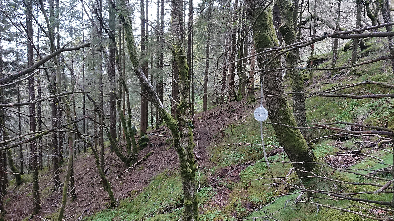 Short evening hike to visit the ruins of Steinhytten southwest of Ulriken. The cabin was easily located and only required a short detour from the trail. From the ruins I followed a weak trail north, marked with lots of small reflectors and apparently sponsored by NRK. Later I connected with the steep trail to/from Ulriken which I followed southwest down to the road.
Cabin ruins: Landåsfjellet - Part 2
- Date:
- 13.05.2020
- Characteristic:
- Hillwalk
- Duration:
- 2:26h
- Distance:
- 7.8km
 A return to Landåsfjellet to visit some of the ruins I had either skipped on my last visit or where I had been uncertain of the location. First up was Norheim , where I had an approximate location from Bergensernes Fjellverden II (BF II), which combined with the accompanying pictures enabled me to quickly locate a location that seemed to match. Only very weak traces left of the cabin itself.
Next, I moved on to Bryterhytten , again making good use of the information in BF II and easily locating the weak traces of the cabin. Limited traces here as well. The cold wind had now started to pick up, so I did not stay long, and even forgot to visit the summit of Orrehaugane , before moving on to Fjellro .
Fjellro was one of those location I was sure I had visited on my previous visit, but where I was not sure of the exact location. This time >>>
A return to Landåsfjellet to visit some of the ruins I had either skipped on my last visit or where I had been uncertain of the location. First up was Norheim , where I had an approximate location from Bergensernes Fjellverden II (BF II), which combined with the accompanying pictures enabled me to quickly locate a location that seemed to match. Only very weak traces left of the cabin itself.
Next, I moved on to Bryterhytten , again making good use of the information in BF II and easily locating the weak traces of the cabin. Limited traces here as well. The cold wind had now started to pick up, so I did not stay long, and even forgot to visit the summit of Orrehaugane , before moving on to Fjellro .
Fjellro was one of those location I was sure I had visited on my previous visit, but where I was not sure of the exact location. This time >>>
