Archive - Date
Archive - Activity
-
Climbing (43)
- Alpine climbing (31)
- Ice climbing (3)
- Mixed climbing (1)
- Sport climbing (3)
- Via ferrata (1)
-
Other trip (5)
- Expedition (5)
-
Other winter trip (5)
- Snowshoe trip (5)
-
Ski trip (449)
- Backcountry skiing (4)
- Cross-country skiing (2)
- Randonnée/Telemark (441)
-
Trip by foot (507)
- Alpine trip (47)
- Hike (196)
- Hillwalk (205)
- Jogging (4)
- Walk (55)
Peakbook-Friends


Ben Lui
- Date:
- 11.04.2010
- Characteristic:
- Hike
- Distance:
- 22.0km
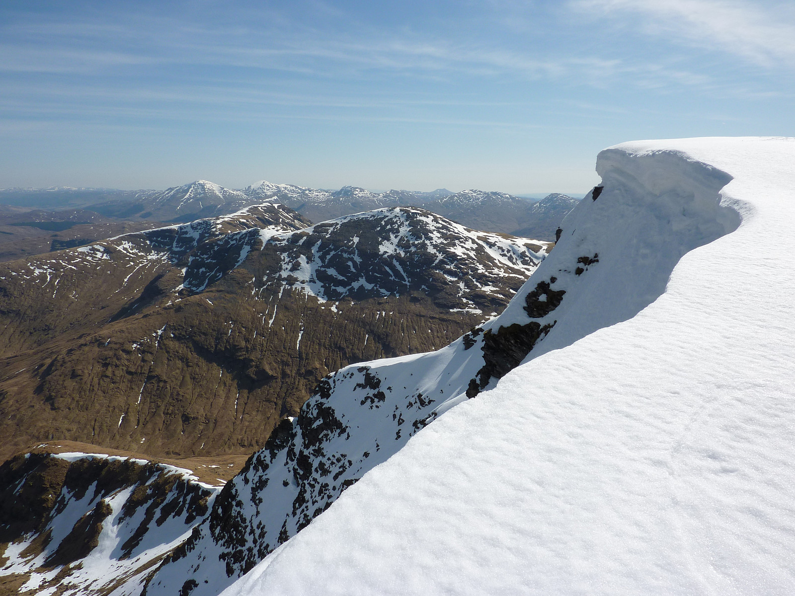 On recommendation from a climbing friend, I chose to take a hike up Ben Lui. I was staying at the youth hostel in Crianlarich so it made sense to find something close by. It was a bright and lovely spring morning in the central highlands, and I was very excited to get hiking after a short drive down the road to the car park at Dalrigh, between Crianlarich and Tyndrum. It was about 5 degrees when I left the car park and started on the slightly tedious track leading up beside the Cononish river. It's about 6 or 7km of flat stony track to walk along until you actually start an ascent, but with magnificent views of Ben Lui's eastern face overlooking the route, it wasn't all that bad really. I was overtaken on several occasions by bikers, some with skis fixed to their rucksacks and some without >>>
Ben Arthur
- Date:
- 10.04.2010
After sleeping at the very grand Loch Lomond youth hostel the previous night, I took a short drive a bit further north to Succoth where I could make an ascent of the Cobbler. It was warm, sunny and felt properly into summer; however I had neglected to bring a map with me and was kind of hoping that the route up would be obvious. Fortunately for me though my hopes were fulfilled and after getting out of the forests, I couldn't get too lost on the nice footpath which was currently filled by lots of other eager hillwalkers. Great views of Loch Long and of the jagged profile of the Cobbler itself pretty much defined the hike, and there was some nice opportunities for scrambling to get to the top as well. It was a bit hazy though - my only complaint about the very warm and sunny weather! After some >>>
Broken Fingers (III) and Red Gully (II)
- Date:
- 22.03.2010
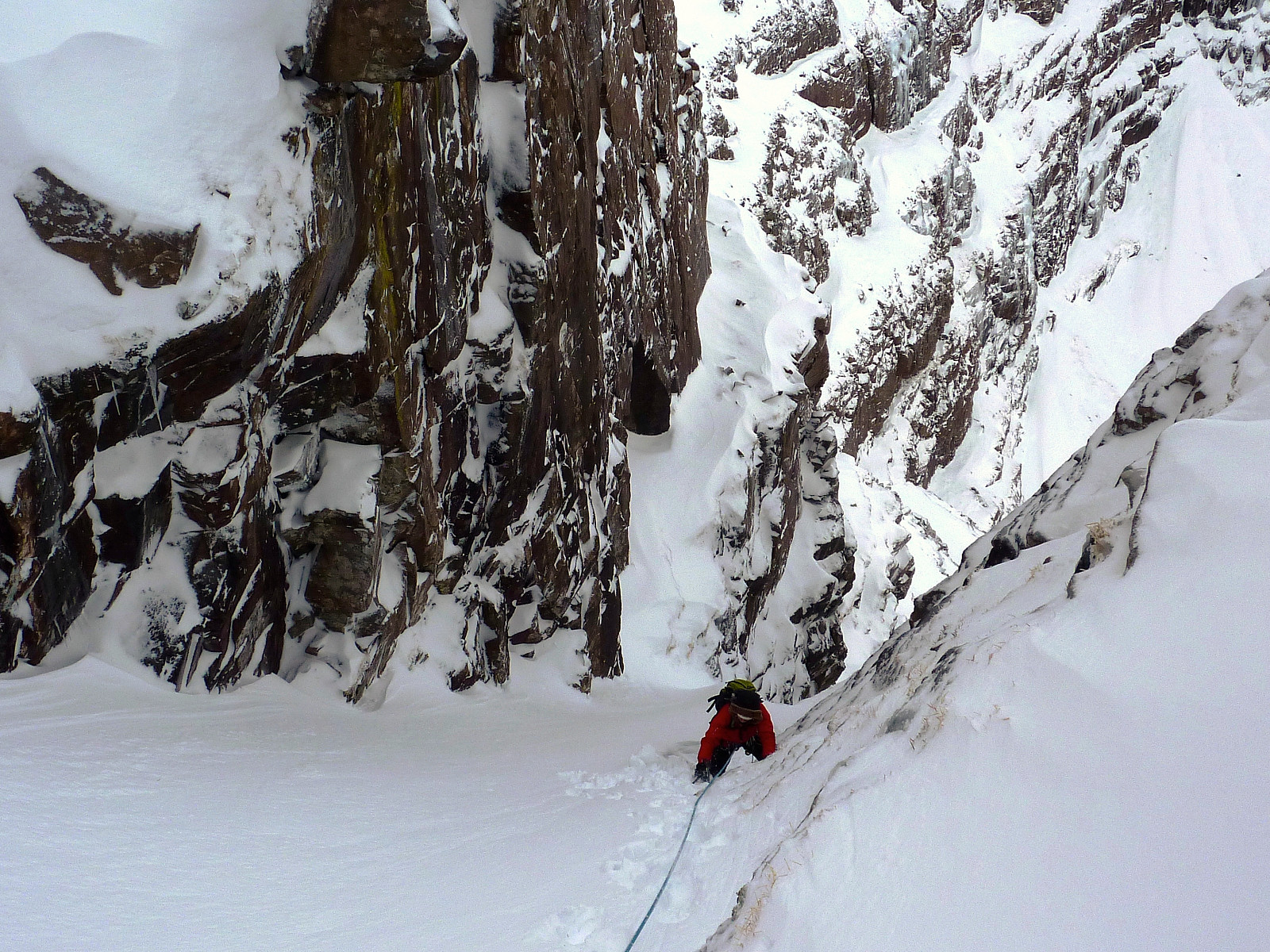
James' boss had quite kindly let him borrow the chalet just outside Aviemore for a few nights, and so we had only a short drive to get up to the ski car park where we took the short walk into Coire an t-Sneachda. It was a pretty quiet day, windy on the tops as always but not too many other climbers on the routes. Fortunate for us really! James had done Fingers Ridge (IV) not too long ago so we decided on a variation of Broken Gully and Fingers Ridge, otherwise known as Broken Fingers. Snow cover was a bit lean after leaving the gully, but it was a fantastic route nonetheless. Some nice delicate moves to work on and we found ourselves topping out in almost no time. After a descent back into the coire, we went up Red Gully. James lead the first pitch, I did the second and then we almost moved >>>
Skiddaw
- Date:
- 07.03.2010
After our previous day's hike in the Borrowdale valley, this time myself and Jay took a more local walk, and up Skiddaw. Fantastic weather and conditions underfoot were a guarantee for a great day out, and despite starting off in a winter jacket, I was down to my vest top by the time we reached the top of Skiddaw. The sun shone perfectly over the snow-covered fells and it was a superb hike all round. We joined lots of other happy hikers at the summit for some lunch, before taking the eastern slopes down toward Skiddaw House. Once we'd reached here, we followed the footpath skirting above Glenderaterra Beck to get back to Keswick.
Seathwaite circuit
- Date:
- 06.03.2010
With winter still in full swing in the Lakes, I was back up with a friend of mine from Loughborough. We had been staying at the Derwentwater youth hostel the previous night, so we had good access to the Borrowdale fells and beyond. In the end we decided on a route from Seatoller, which took in the ascent of Glaramara. It was a nice stony path to start off with, but by the time we neared the summit, shortly behind a party of lads, there was a good covering of snow. More traipsing through snow ensued to descend and walk along to Allen Crags, with great views over to Honister and the western fells. From Allen Crags we headed down in the direction of Esk Hause before bearing in a (north?)westerly direction towards Sprinkling tarn and Styhead tarn. From there we made one last ascent of the day to >>>
An Teallach, Constabulary Couloir
- Date:
- 20.02.2010
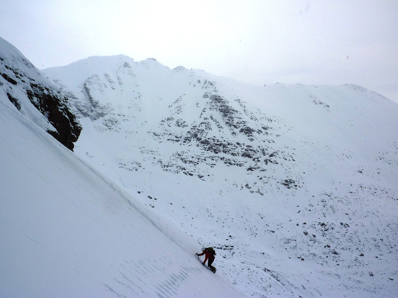 An attempted ascent of An Teallach via Constabulary Couloir with Lucy, Andy and Suzana. Initially the snow in the lower part seemed pretty unstable; soft and very deep. However, higher up in the gully we had excellent neve conditions and it was perfect for soloing up with crampons and an ice axe. Lucy was on good form, and made a bomber pace up the route, topping out much before myself and Suzana got there! The weather was lush too, crisp and cold - just how all winter days should be! But by the time we had reached the ridge before the traverse of An Teallach started properly it was already starting to get dark again. Suzana and I roped up thinking that the terrain was going to become infinitely more difficult from there, but we didn't actually tackle the main difficulties of the ridge because >>>
Hidden Gully (II)
- Date:
- 17.02.2010
- Characteristic:
- Alpine trip
 Alternated leads with Suzana while Rocio soloed up with us. Nice route, but the snow wasn't particularly neve-like, especially after the second pitch so it felt more like a steep walk rather than a proper climb. Still, we had some practice in moving together on a short rope on the descent off Stuc a'Choire Dhuibh Bhig with fantastic views into the wilderness north of the Liathach massif - the first day of the week (possibly) we'd had any decent views at all.
East Buttress (IV)
- Date:
- 15.02.2010
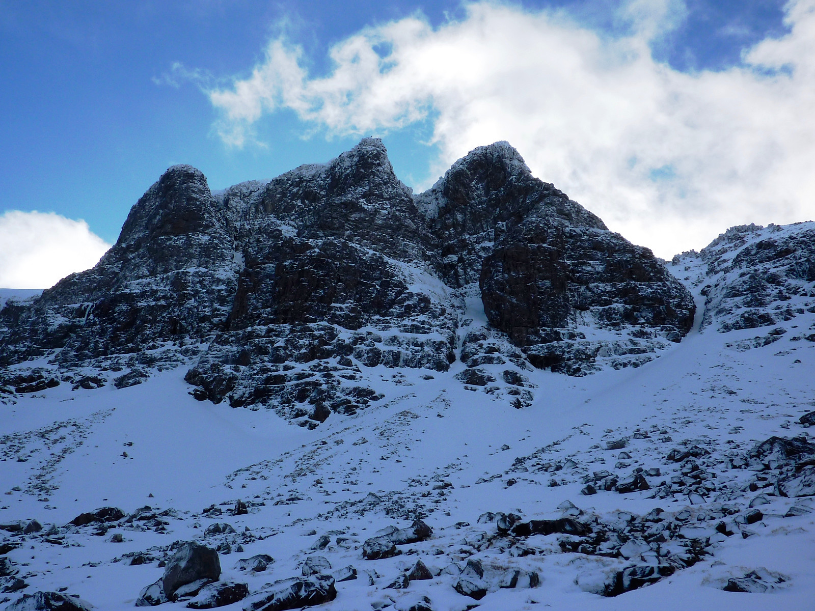 We started the day with an hour's drive from Lochcarron into Torridon, parking up at the foot of the valley between Beinn Eighe's western end and Liathach's eastern end. It was about 8am when we got out to begin the long walk in to the coire on the northern side of Coinneach Mor; in fact it was altogether dismal to start off with, rain being chucked down like you wouldn't believe. Nevertheless, after much dithering around we eventually set out in the soaking wet conditions anyway and about 3 hours later we were finally round and into the coire, looking in awe up at the Triple Buttresses. We were going to climb the grade IV route up the East Buttress, which was at that moment looking decidely thin and uninviting for me as someone who has a fear of mixed routes.
It turned out to be quite a long >>>
We started the day with an hour's drive from Lochcarron into Torridon, parking up at the foot of the valley between Beinn Eighe's western end and Liathach's eastern end. It was about 8am when we got out to begin the long walk in to the coire on the northern side of Coinneach Mor; in fact it was altogether dismal to start off with, rain being chucked down like you wouldn't believe. Nevertheless, after much dithering around we eventually set out in the soaking wet conditions anyway and about 3 hours later we were finally round and into the coire, looking in awe up at the Triple Buttresses. We were going to climb the grade IV route up the East Buttress, which was at that moment looking decidely thin and uninviting for me as someone who has a fear of mixed routes.
It turned out to be quite a long >>>

