Hukebu

Name Hukebu
Search name Hukebu
Type Shelter
Elevation 640 meter
Region Bygland
Parent regions Europe, Norway, Norway mainland, Aust-Agder
Adviser admin (Administrator)
Last modification 16.05.2016
Beds
Hosts
Season
Coordinates 32V 425600 6507139 (UTM)
Map Show object on map

Notice: Smarty error: html_image: unable to find 'gfx/pbes/fd/53/fd534ba27cc20651b56d18ee2317f2fd/3.jpg' in /var/www/test.peakbook.org/httpdocs/libs/smarty/libs/Smarty.class.php on line 1092
Content
Language
Adviser none
Statistics

Register visit of Hukebu.

One member has registered one visit of Hukebu.

Map

Pictures

Introduction

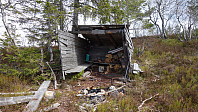
Dette uhøytidelige skuret ble satt opp i 2005 og ligger langs den merkede løypa som går mellom Otrahytta (som nå er i privat eie) og Sandsvatnet. Det er en postkasse inni skuret med bok oppi, hvor mange har skrevet seg inn fra 2005 og frem til nå.

Getting there

Winter

Tips and miscellaneous

Pictures

Starting points

External links

Literature and references

Other pictures

Trip Reports

User comments

Comment title:
Characters left: 1000
Comment text: