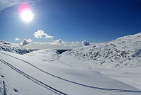
Skiing Livarden (28.02.2016)

Geschrieben von HHauser (Helwig Hauser)

| Startpunkt | Riple (290m) |
|---|---|
| Endpunkt | Riple (290m) |
| Tourcharakter | Tourenskilauf |
| Tourlänge | 3h 15min |
| Entfernung | 10,8km |
| Höhenmeter | 523m |
| GPS |
|
| Besteigungen | Livarden (683m) | 28.02.2016 |
|---|---|---|
| Besuche anderer PBE | Birkehaug (privat) (281m) | 28.02.2016 |
| Fanahytten (296m) | 28.02.2016 | |
| Mindehytten (ruin) (325m) | 28.02.2016 | |
| Totland p-plass (287m) | 28.02.2016 | |
| Ulvursfjellet (606m) | 28.02.2016 | |
| Ulvursvarden (677m) | 28.02.2016 | |
| Øvre Totland parkering (280m) | 28.02.2016 |

Trip Summary
We parked near Fanahytten, went a few steps, passing Fanahytten, before we crossed over to the other side (Totlandsfjellet), walking down the road for a few meters. Parallel to Totlandsvegen as well as Totlandsfjellet, we ascended in the direction of Livarden, following a track that others had used before us (not too many, but some). Instead of skiing on the top of Totlandsfjellet, we proceeded below it, somehow on middle-height between the valley and the mountain ridge. At the point, where we switched over from Totlandsfjellet to Livarden, basically, we ascended through a narrow, little valley, called Gråsmoget. From there, we followed the track, ascending step by step to the height of Livarden. Particularly this stretch, from Gråsmoget up to the top of Livarden, was especially nice---winter heaven, very near to Bergen! From the top of Livarden, we then followed the more traditional route, along the high ridge, back towards the parking place. All in all, this skiing trip was exceptionally nice---truly a wonderful memory for years to come! :-)
Photos
Selected photos are available as Google+ photo album.
Useful Resources
Web page WestCoastPeaks.com provides useful information about Livarden
and also Petter Bjørstad has a page about Livarden.
On Bergentopp 200 there is a page (in Norwegian) about Livarden.


Benutzerkommentare