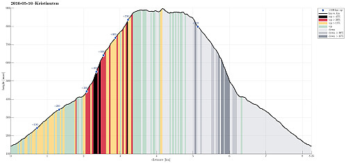
Kristinuten (16.05.2016)

Geschrieben von HHauser (Helwig Hauser)

| Startpunkt | Øydve (140m) |
|---|---|
| Endpunkt | Øydve (140m) |
| Tourcharakter | Bergtour |
| Tourlänge | 4h 00min |
| Entfernung | 8,3km |
| Höhenmeter | 802m |
| GPS |
|
| Besteigungen | Kristinuten (901m) | 16.05.2016 |
|---|---|---|
| Besuche anderer PBE | Jobykset (267m) | 16.05.2016 |
| Øydvekleppe (690m) | 16.05.2016 |

Trip Summary
We started from the road between Ulvik and Osa, driving basically to the top of the saddle (between Ulvikafjorden and Osafjorden). There, we continued a little bit further on a side road the passes by Øydve. When getting close to the forrest, we parked and started hiking. The first 300 height meters are convenient on a forrest road that winds back and forth towards Liastølane. Then, one needs to pay attention. A sign ("Kleppe", I think) tells to leave the forrest road and continue along a minor path. This trail is really hard to find---the best tip is to look out for small stones that mark the path. One first ascends further through the forrest before reaching the tree line very soon. From there, it is basically straight up to the top of Kristinuten. It is recommended to memorize well where the forrest path ends/starts in order to find the way back well. Since Kristinuten is "only" 900 meters high, one quickly reaches the top. The views are surprisingly amazing from up there, especially also towards Vassfjøro! We made a short break on the top and continued then (first a little around the more or less flat top, before then heading back). We started out hike back on the eastern edge of Kristinuten to also enjoy some fantastic views over Osafjorden. We then returned basically the same trail that we used for hiking up. Kristinuten seems to be a non-spectacular mountain, at the first sight, but once on the top, one really has some very nice views in all directions!
Photos
Selected photos are available as Google photo album.
Useful Resources
See also the related FB-page Hiking around Bergen, Norway.


Benutzerkommentare