Via Gråfjellet towards Sveningen (05.10.2014)

| Startsted | Løyningdalen (12moh) |
|---|---|
| Sluttsted | Løyningdalen (12moh) |
| Turtype | Fjelltur |
| Turlengde | 6t 30min |
| Distanse | 18,1km |
| Høydemeter | 1233m |
| GPS |
|
| Bestigninger | Gråfjellet (485moh) | 05.10.2014 |
|---|---|---|
| Midtfjellet (446moh) | 05.10.2014 | |
| Selsfjellet (362moh) | 05.10.2014 | |
| Utløfjellet (723moh) | 05.10.2014 | |
| Andre besøkte PBE'er | Øvredalen parkering (39moh) | 05.10.2014 |


Trip Summary
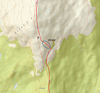
We parked the car in Løyningdalen, right next to the street into Øvredalen. We then crossed the river (bridge) and continued into Stordalen. Following Stordalen, we passed by Gråfjellet and climbed up to Midtfjellet first. From there, we changed over to Gråfjellet, going a bit back in direction. From Gråfjellet, we then descended to Leina and followed the ridge in direction Baggeskaret. Most of this is without any path and you better have a bit of an adventure-spirit to try this connection. From there we continued along the ridge, first via Selsfjellet and then to Utløfjellet, before we started a quite steep ascent towards Sveningen. Basically, most of this tour was along the border between Os and Samnanger. See the image for the part of the trip which was (too?) steep. Maybe, it's better to try an ascent a bit more west than this. After having almost reached the top of Sveningen, we descended into Øvredalen (on the trail which connects Øvredalen and Sveningen). All in all, this tour was quite long (> 6 hours) and quite a bit demanding (because most of the connection between Gråfjellet and Sveningen was without any trail).
Photos
Two selected photos are available as Google photo album.
Useful Resources
Web page WestCoastPeaks.com provides useful information about Gråfjellet as well as about Sveningen, Søtefjellet, Sauskolten, Rindafjellet, and Midtsæterfjellet
and also Petter Bjørstad has a useful page about Gråfjellet and another useful page about Sveningen.


Kommentarer