Archiv - Nach Datum
Archiv - Nach Aktivität
-
Andere Tour (1)
- Expedition (1)
-
Andere Wintertour (6)
- Schneeschuhtour (6)
- Fahrradtour (2)
- Fußtour (211)
-
Klettern (8)
- Alpinklettern (7)
- Mixed-Klettern (1)
-
Skitour (40)
- Randonnée/Telemark (40)


Gesammelte Listen
-
Romsdal ≥ 100m pf.
(131/301)
 43%
43% -
Sunnmøre ≥ 100m pf.
(75/531)
14%
-
Norges 1000 største fjell målt i primærfaktor
(50/1000)
5%

From Djuv to Storehornet on Godøy Island
- Datum:
- 04.07.2015
- Tourcharakter:
- Bergtour
- Tourlänge:
- 1:49h
- Entfernung:
- 3,3km
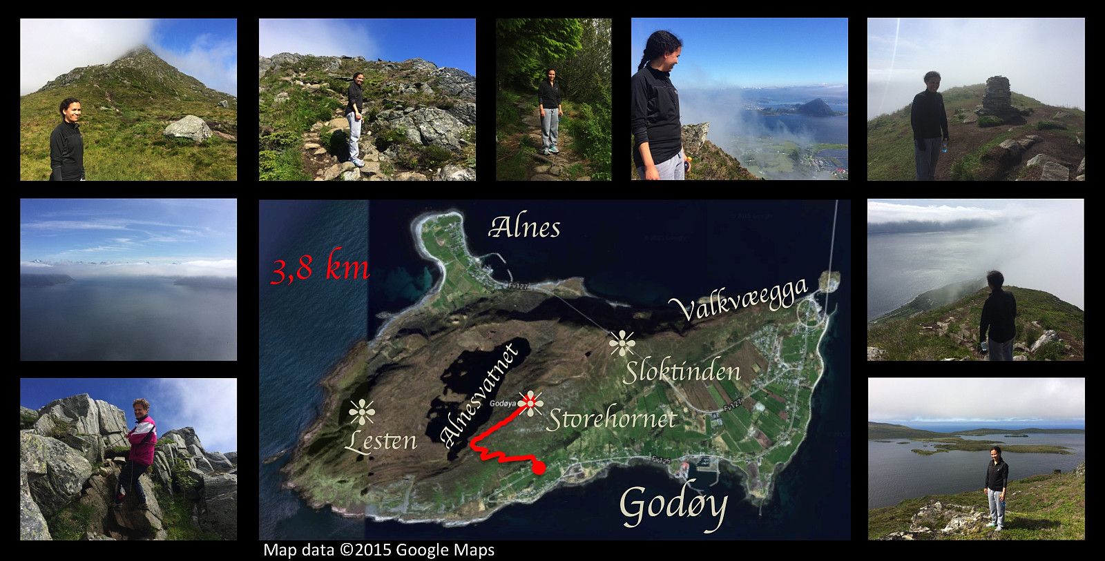 On this day I had a very nice trip to the summit of Storhornet on Godøy Island along with my older daughter. We went by car to a nice parking spot that has been made for mountain trekkers at Gjuv, and started our trek from there. The path up to about 270 m.a.m.s.l. is quite nice though a little bit wet in the upper part. Following this path you reach a mountain pass between Mount Storhornet on one side and Mount Lesten on the other side. From there the rather nice path goes down to the lake Alnesvatnet. Just there in the pass, however, you just take a track up to the right [i.e. eastwards], and this track will then lead you up to the summit of Storhornet. On this particular day, we noticed as we embarked on this last, rather steep climb, that the summit of the mountain was shrouded in clouds. >>>
Summiting Storhornet on Godøy Island twice in a day.
- Datum:
- 20.06.2015
- Tourcharakter:
- Bergtour
- Tourlänge:
- 5:48h
- Entfernung:
- 17,6km
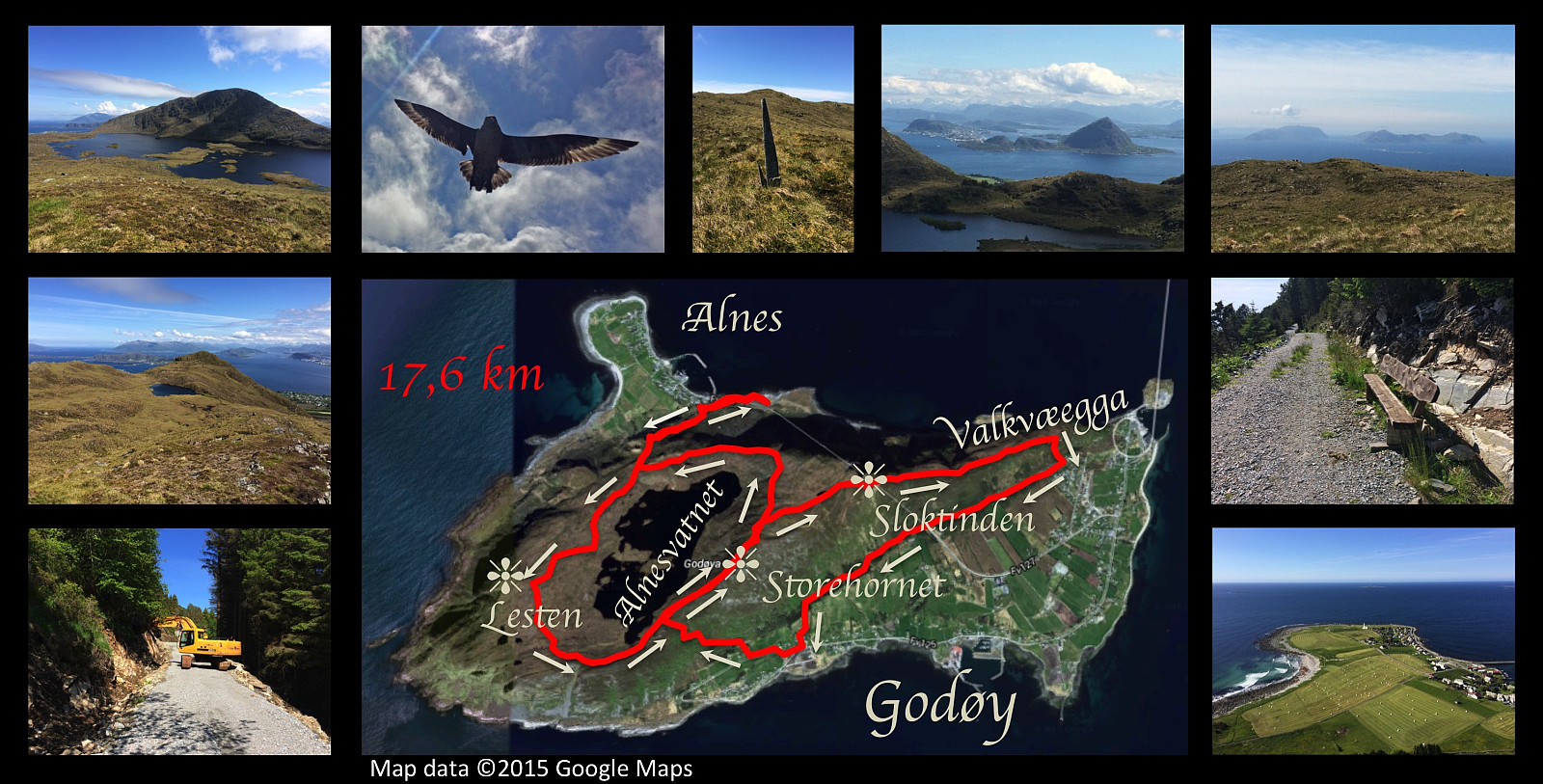 I had another nice hiking trip on the mountain of Godøy island this day. I started out from Alnes, and climbed up to the lake Alnesvatnet; then circumscribed the lake taking a track that I haven't used earlier. I had previously walked along the shore of the lake, and also over the mountain called Lesten, but this time I chose an in-between path about midway between the lake and the summit of Lesten, before ascending the final climb to the peak Storehornet, 497 meters above sea level. From Storehornet I went down the mountain ridge Valkvæegga to Valkvæ, and then westwards to Djuv on the south side of the mountain along a road under construction called Fjellfotveien (i.e. The Mountain Foot Road ). From Djuv I then climbed up to Storehornet a second time on this day, before finding my way down >>>
Round-trip on eastern part of the mountain of Godøy Island
- Datum:
- 13.06.2015
- Tourcharakter:
- Bergtour
- Tourlänge:
- 4:43h
- Entfernung:
- 14,8km
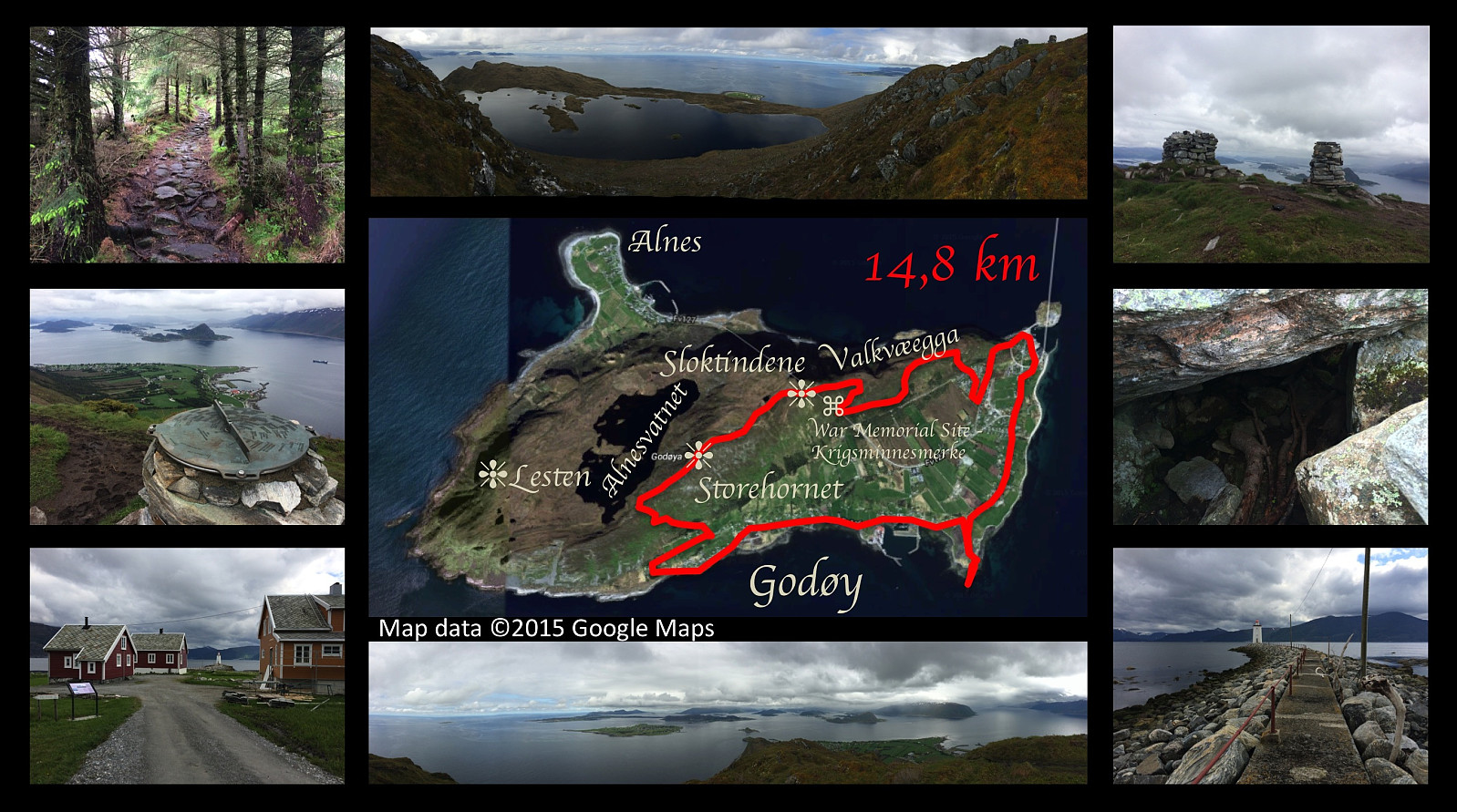 On this day I went for yet another hike on the mountain of the island Godøy, close to were we're living. This time I set out from a place called Djuv (or Juv) on the south side of the Island, and climbed towards the summit of the island, i.e. the peak called Storhornet. From Storhornet I took a somewhat peculiar way northeastwards, however, following first a little edge downwards to a viewpoint overlooking the southern and eastern parts of the island. From this spot I climbed back up to the pond called Lillevatnet, however, and then onto the peak called Sloktinden (there is actually about three peaks that are called Sloktindane [in plural form] by the locals, hence the singular form Sloktinden is something you're not likely to hear apart from here on Peakbook; anyway I climbed onto the easternmost >>>
Hiking Mount Sulafjellet with my cousin and my two sons.
- Datum:
- 06.06.2015
- Tourcharakter:
- Bergtour
- Tourlänge:
- 6:27h
- Entfernung:
- 11,6km
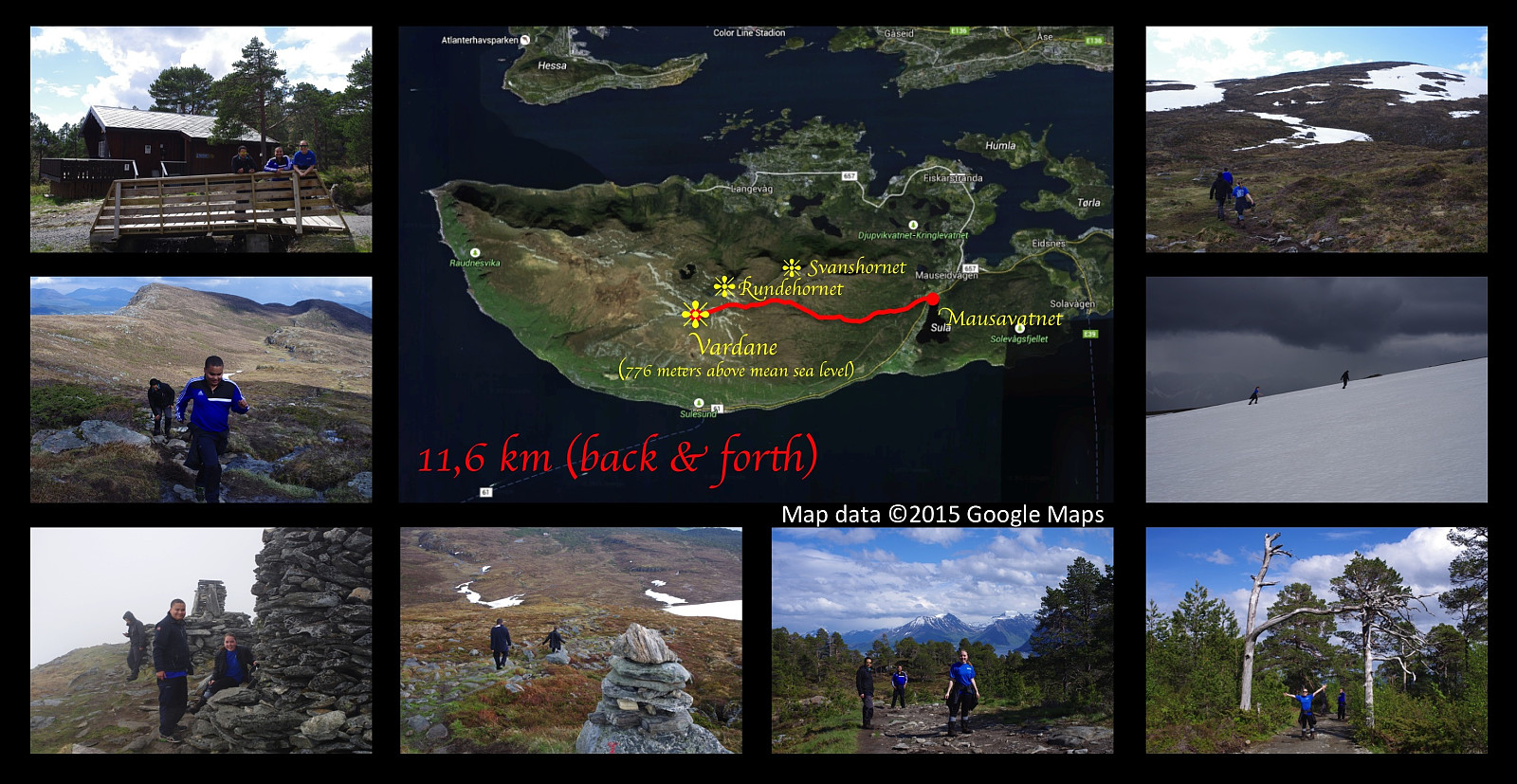 I went hiking on a very nice mountain trip on this day with my two sons Bror and Dag and my cousin Savanna . We set out from lake Mausavatnet, and climbed the mountain of the island Sula, located just south of Ålesund, up to its highest peak commonly called Vardane , 776 meters above mean sea level. The weather was nice with sunshine for most of our trip, but as we were approaching the summit, it changed within minutes to foggy, cold, rainy, and very windy; hence we were robbed of the nice view that we were anticipating to have at the peak of the mountain. I had planned to shoot a picture of Savanna and my boys with our home island of Vigra in the background, but that didn't work out... Being completly soaked by the rain, we couln't risk getting cold by waiting for the weather to improve, and >>>
A figure-of-8 hike on Godøy Island.
- Datum:
- 16.05.2015
- Tourcharakter:
- Bergtour
- Tourlänge:
- 3:34h
- Entfernung:
- 11,1km
 On this nice day, I went once again hiking on the mountain of the island Godøy, taking a different route from what I had done before. As on previous trips I parked our car at Alnes, climbed up to lake Alnesvatnet, and crossed the island close to the shore of the lake; though I also took time to visit a little peninsula and a little island in the lake, before I started climbing up to the peak Storehornet. From the mountaintop, I descended along the mountainridge Valkvæegga for a distance, then took a track down to Godøy Primary School, and finally returned to my car at Alnes jogging through the tunnel. The tunnel runs from Støbakk on one side of the island, to Alnes on the other; and it runs just beneath the mountain peak called Sloktinden. It opened in December 2006, is about 1,5 km long; >>>
A larger round trip of the mountains of the Island Godøy.
- Datum:
- 09.05.2015
- Tourcharakter:
- Bergtour
- Tourlänge:
- 3:55h
- Entfernung:
- 12,9km
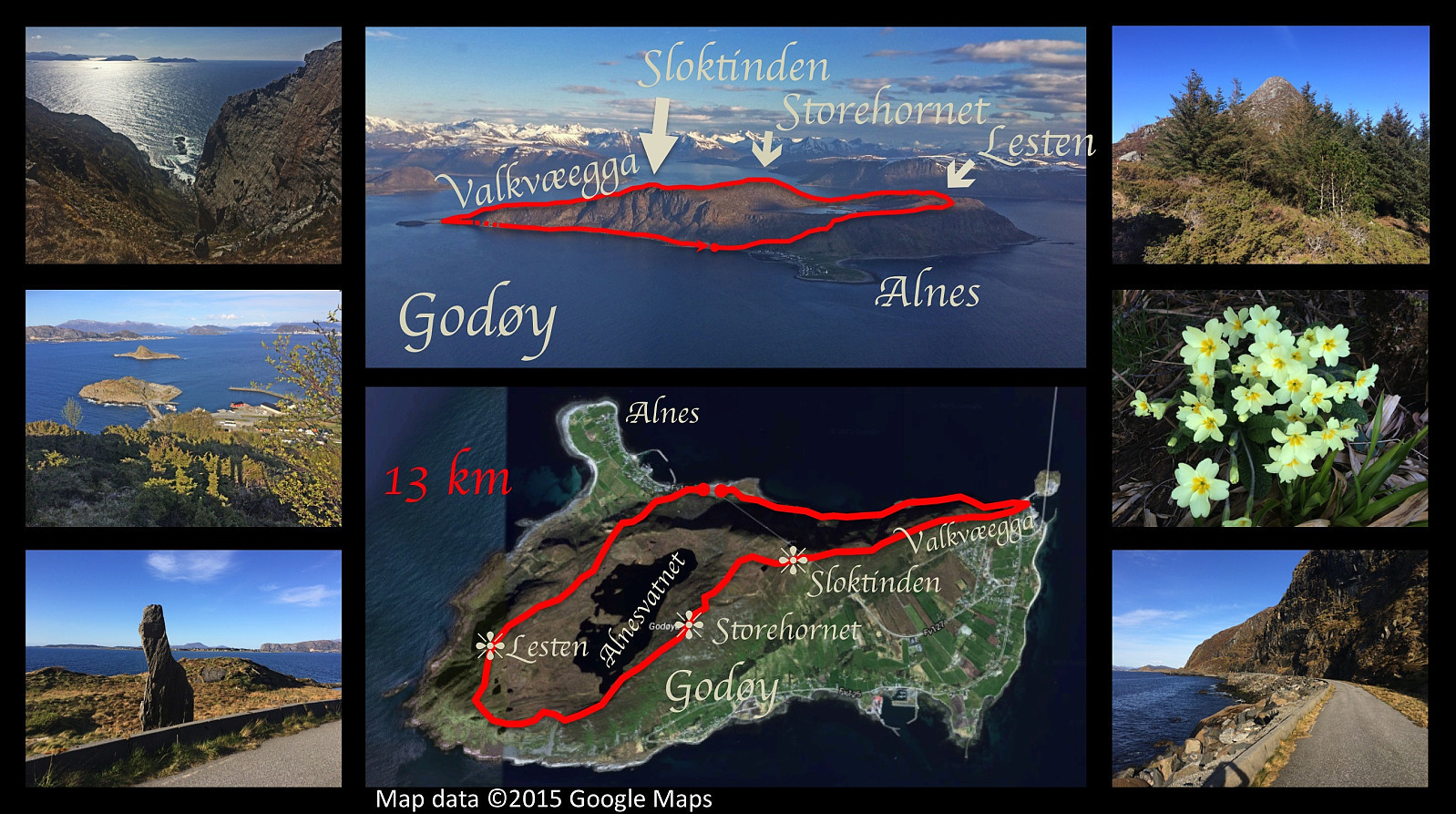 On this day we had extremely nice weather in the area, and so I had another really nice trip on the mountain of the island Godøy. I first climbed the rather steep climb from the headland/ness called Alnes up to Lake Alnesvatnet, located on a platau about 250 meters above mean sea level. Then a not-so-steep walk to the peak of mount Lesten (altitude 357 meters), from there almost down to the other end of Alnesvatnet, and directly onto a very steep climb up to the peak of Storehornet (497 meters), next onto the peak of Sloktinden (436 meters), and then all the way down to sea level again along the mountain ridge called Valkvæegga. I finally walked the old Alnes road back to Alnes where I had my car parked.
A round trip on the mountain of the Island Godøy.
- Datum:
- 02.05.2015
- Tourcharakter:
- Bergtour
- Tourlänge:
- 3:32h
- Entfernung:
- 10,3km
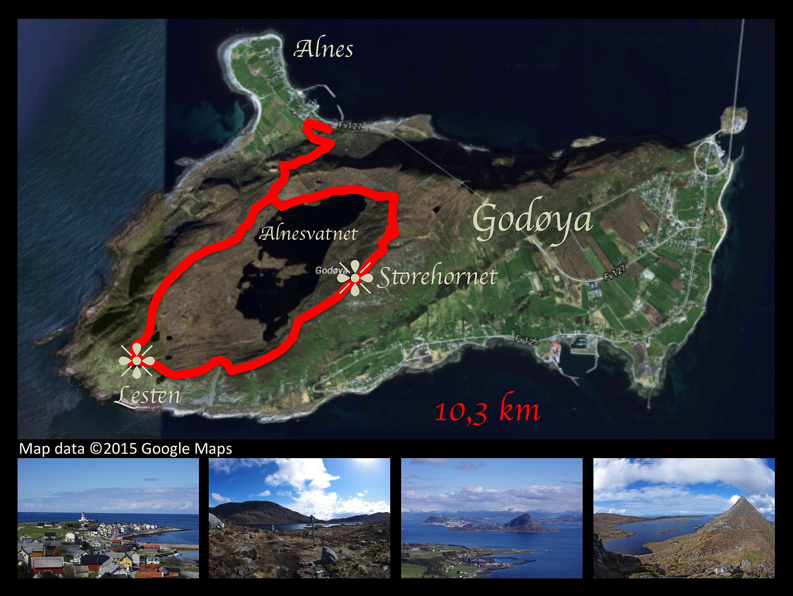 On this day I had a nice trip walking the mountains of Godøy Island. Weather was nice, and the scenenery was picturesque. The climb from the promontory of Alnes is rather steep to begin with, but you then reach a plateau at about 250 meters above mean sea level, on which is located a lake called Alnesvatnet. This lake is ideally located as a drinking water reservoir for the entire municipality of Giske, which is constituted of four inhabited islands along with a number of uninhabited islets. The lake is located substantially higher than any of the inhabited areas of the municipality, hence there's sufficient water pressure to reach all the houses in need of water. Once on the plateau, you walk along Alnesvatnet to its eastern end, and then you follow the track up a rather stony mountain edge >>>
A short trek to Mount Myklebusthornet on Ellingsøy Island
- Datum:
- 25.04.2015
- Tourcharakter:
- Bergtour
- Tourlänge:
- 1:40h
- Entfernung:
- 5,2km
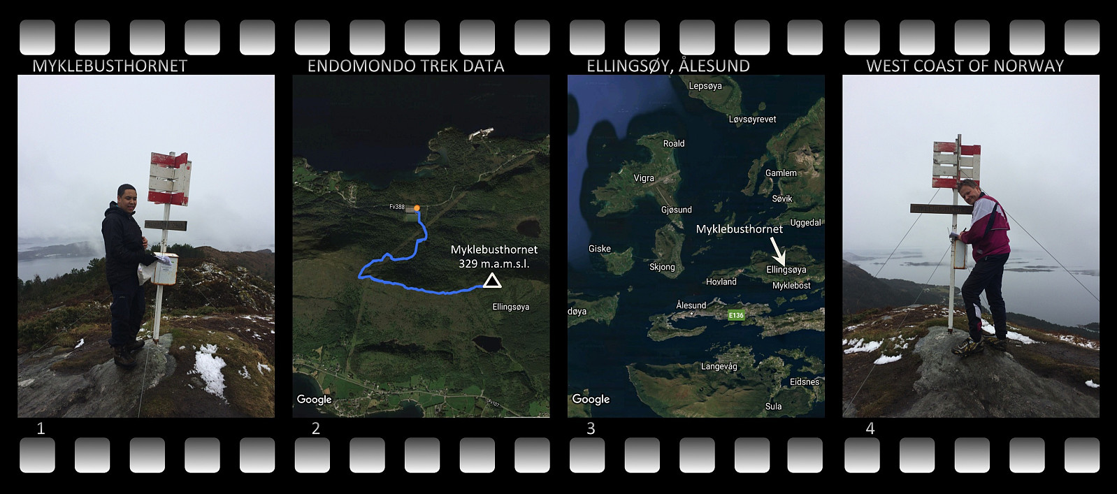 I went for a mountain trek with my oldest son this day to the island called Ellingsøya . The island has a mountain ridge in east-west direction, which stretches along most of the island. The ridge is usually just reffered to as Ellingsøyfjellet [i.e. "the Ellingsøy mountain"], but it has several peaks along its course, called Vikenakken, Sperrenakken and Myklebusthornet, among which Myklebusthornet is the highest. We parked at the parking spot of a local football field on the north side of the island (Nes Stadion). The climb to Myklebusthornet from this spot is about 2,6 km, making the trip 5,2 km including the decent back to the parking spot. The peak is 329 meters above mean sea level, about 300 meters above the altitude at which we parked the car.
The peak is located just above >>>
I went for a mountain trek with my oldest son this day to the island called Ellingsøya . The island has a mountain ridge in east-west direction, which stretches along most of the island. The ridge is usually just reffered to as Ellingsøyfjellet [i.e. "the Ellingsøy mountain"], but it has several peaks along its course, called Vikenakken, Sperrenakken and Myklebusthornet, among which Myklebusthornet is the highest. We parked at the parking spot of a local football field on the north side of the island (Nes Stadion). The climb to Myklebusthornet from this spot is about 2,6 km, making the trip 5,2 km including the decent back to the parking spot. The peak is 329 meters above mean sea level, about 300 meters above the altitude at which we parked the car.
The peak is located just above >>>
Hiking to Mount Ulriken in Bergen
- Datum:
- 20.04.2015
- Tourcharakter:
- Bergtour
- Tourlänge:
- 2:15h
- Entfernung:
- 6,2km
 This afternoon I had a nice trip on mount Ulriken in Bergen in wonderful sunshine. The nature's just beautiful at spring time, and as its getting gradually warmer at this time of the year, I actually had a haircut before I started hiking. For the mountain climb I used a trail that runs more or less along the cable car (or actually beneath it). To have some variation, however, I chose a different, and somewhat longer route for the descent. The descent path kind of encircles part of the mountain plateau which Ulriken is a part of, and then you descend from the plateau at a spot where the altitude is a bit lower. This longer path takes you to a number of small mountain lakes or ponds, in some of which you're allowed to have a bath i you so desire. It was still just April, however, and therefore >>>
Kveldstur til Ulriken
- Datum:
- 29.10.2014
- Tourcharakter:
- Bergtour
- Entfernung:
- 5,0km
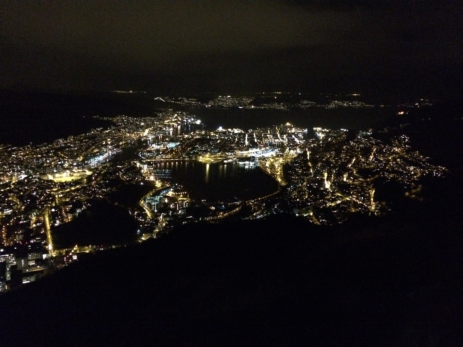 Jeg arbeider i Bergen, og leier en pendlerbolig i Haukelandsbakken, så jeg går ofte tur opp på Ulriken og ned igjen. Som oftest har jeg valgt traséen gjennom skogen under Ulriksbanen på vei opp, så også denne dagen. Halvveis oppe tok jeg Bergen-by-night-bildet ovenfor. Jeg fortsatte opp til toppen (med toppen mener jeg her vest-toppen på 607 m.o.h.).
