Archiv - Nach Datum
Archiv - Nach Aktivität
-
Andere Tour (3)
- Kayaking (3)
-
Fahrradtour (108)
- Fahrradtour Straße (83)
- Fahrradtour gemischt (25)
-
Fahrzeugtour (9)
- Autotour (9)
-
Fußtour (1782)
- Bergtour (1054)
- Jogging (1)
- Spaziergang (54)
- Wanderung (673)
-
Skitour (109)
- Langlauf (44)
- Tourenskilauf (65)
Gesammelte Listen
-
Voss ≥ 100m pf.
(96/98)
 97%
97% -
Opptur Hordaland
(143/159)
89%
-
Stasjoner på Bergensbanen
(31/40)
77%
-
Ulvik ≥ 100m pf.
(28/38)
73%
-
Hordaland ≥ 100m pf.
(613/863)
71%
-
Mjølfjell PF > 100m
(21/31)
67%
-
Jondal ≥ 100m pf.
(15/23)
65%
-
Sunnhordland PF >= 100m
(104/186)
55%
-
Dagsturhyttene i Vestland
(33/61)
54%
-
Hordaland: Hardanger PF>=100m
(186/359)
51%
-
Kvinnherad ≥ 100m pf.
(40/79)
50%
-
DNT-hytter i Hordaland
(22/45)
48%
-
Sogndal ≥ 100m pf.
(23/81)
28%
-
Vik i Sogn ≥ 100m pf.
(8/46)
17%
-
DNT-hytter i Sogn og Fjordane
(8/47)
17%
-
Eidfjord ≥ 100m pf.
(7/42)
16%
-
Etne ≥ 100m pf.
(7/51)
13%
-
Ullensvang ≥ 100m pf.
(21/153)
13%
-
Sogn - Sør for Sognefjorden PF>=100m
(17/159)
10%
-
Opptur i Sogn og Fjordane peaks
(17/177)
9%

Ospåsen and Silkesåta
- Datum:
- 21.01.2017
- Tourcharakter:
- Bergtour
- Tourlänge:
- 2:28h
- Entfernung:
- 7,3km
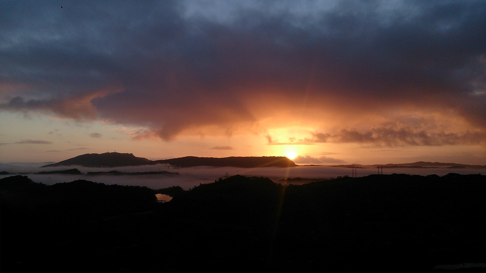
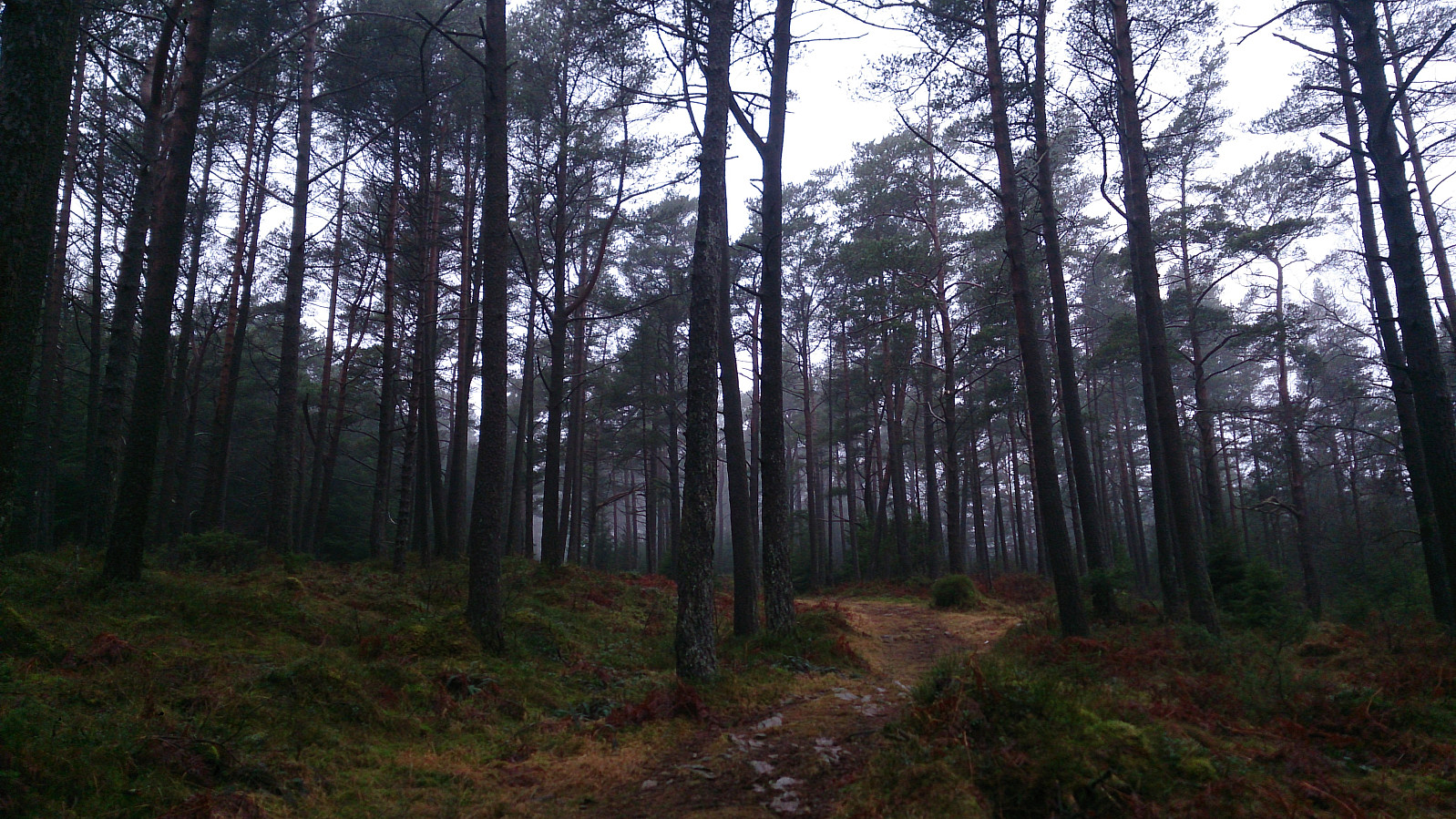 Another trip to Askøy to complete the "Askøy ≥ 100m pf." list. Today the goal was Ospåsen , and I started by taking the bus to Åsebø and from there easily followed the road, and later forest road, to the summit of Ospåsen. The weather was not my friend today though, with quite dense fog, ruining all potential views from the summit.
From Ospåsen I continued south towards Lonevatnet, all the time following trails in a quite dense forest, but as there were so many trails to choose from, picking the right/best one was not always straightforward.
However, in the end I arrived at Lonevatnet and Rv. 562, and crossed the highway to start looking for a path to Silkesåta . I found some trails to follow to what is indicated as Silkesåta on the map. Nothing to see from the summit but trees, and I quickly >>>
Another trip to Askøy to complete the "Askøy ≥ 100m pf." list. Today the goal was Ospåsen , and I started by taking the bus to Åsebø and from there easily followed the road, and later forest road, to the summit of Ospåsen. The weather was not my friend today though, with quite dense fog, ruining all potential views from the summit.
From Ospåsen I continued south towards Lonevatnet, all the time following trails in a quite dense forest, but as there were so many trails to choose from, picking the right/best one was not always straightforward.
However, in the end I arrived at Lonevatnet and Rv. 562, and crossed the highway to start looking for a path to Silkesåta . I found some trails to follow to what is indicated as Silkesåta on the map. Nothing to see from the summit but trees, and I quickly >>>
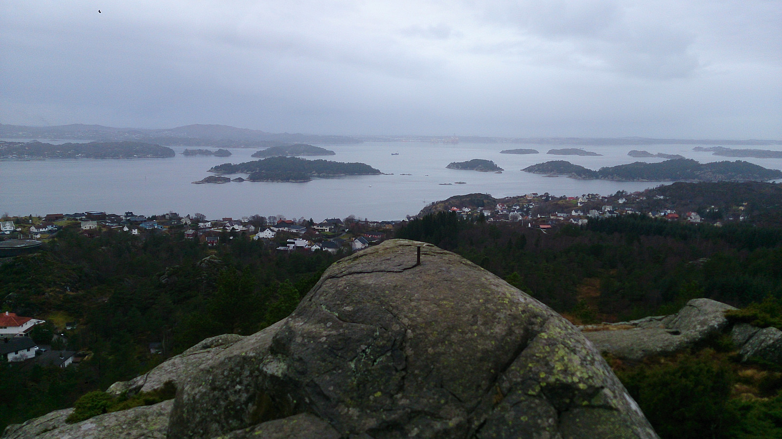
Dronninga
- Datum:
- 15.01.2017
- Tourcharakter:
- Bergtour
- Tourlänge:
- 3:08h
- Entfernung:
- 10,5km
 Started by taking the bus to Ravnanger and from there following the road, and later gravel road, towards Dronninga . Next, I followed a marked trail to the summit, with short detours south and north of the summit for better views. From Dronninga I followed a trail east and then south, heading towards Fjellvassbotnen. When getting there I decided to head back up for a potential viewpoint to the west, only to realize that I could easily have covered this location if I had continued south along the ridge instead of heading directly down to Fjellvassbotnen (see map for details).
I then continued descending towards Haugland, but soon figured out that I had lots of time kill before the planned bus back to Bergen. I therefore decided to take a detour to the peak called Varden på Askøy . Getting to the summit was not difficult, >>>
Started by taking the bus to Ravnanger and from there following the road, and later gravel road, towards Dronninga . Next, I followed a marked trail to the summit, with short detours south and north of the summit for better views. From Dronninga I followed a trail east and then south, heading towards Fjellvassbotnen. When getting there I decided to head back up for a potential viewpoint to the west, only to realize that I could easily have covered this location if I had continued south along the ridge instead of heading directly down to Fjellvassbotnen (see map for details).
I then continued descending towards Haugland, but soon figured out that I had lots of time kill before the planned bus back to Bergen. I therefore decided to take a detour to the peak called Varden på Askøy . Getting to the summit was not difficult, >>>
Hirschenkogel
- Datum:
- 12.01.2017
- Tourcharakter:
- Bergtour
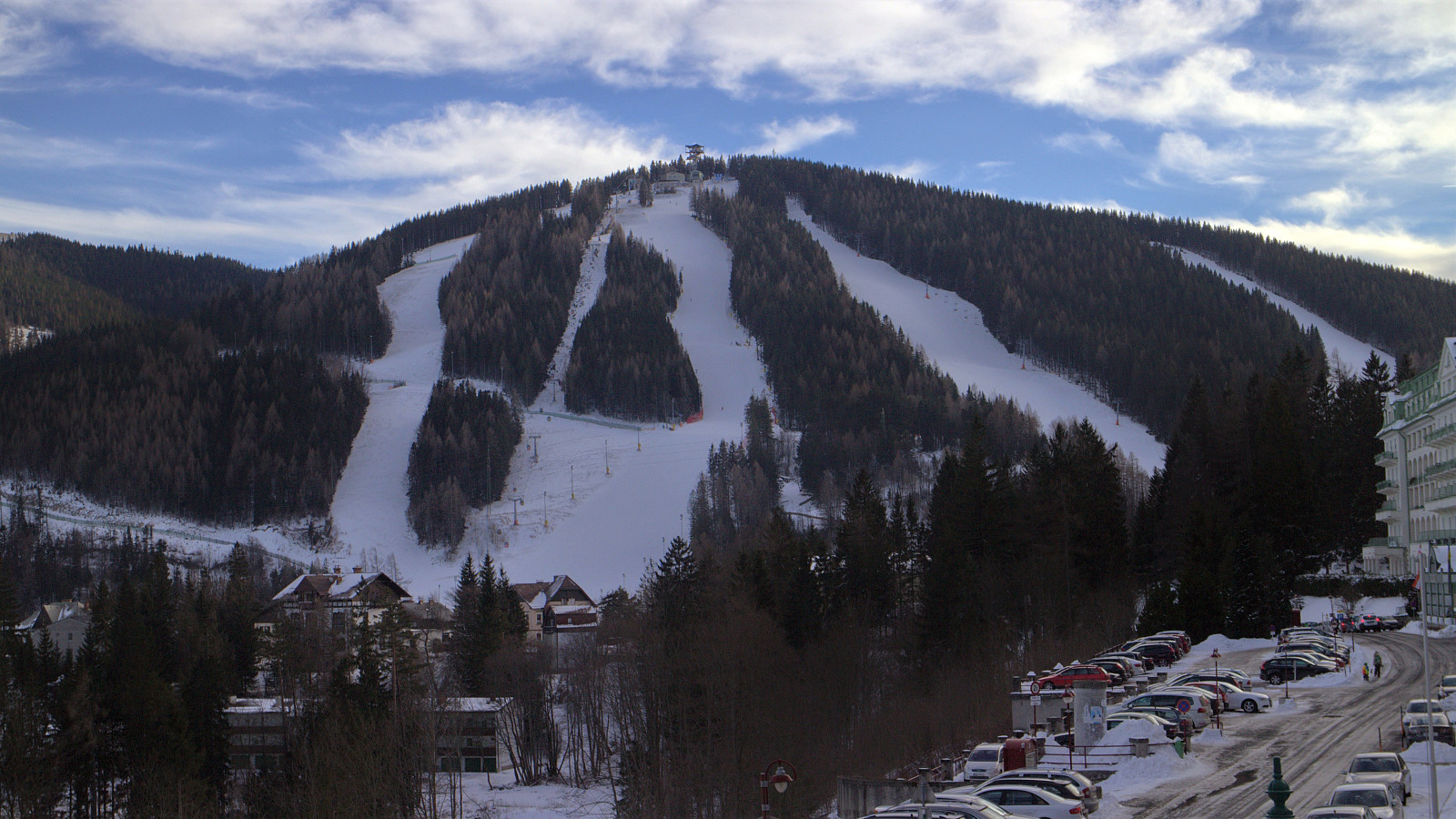 Short hike to reach the summit of Hirschenkogel, starting from the endpoint of the ski lift. At the summit there is a tall wooden lookout tower, which we also climbed. This should normally provide a nice 360 degrees view. However, as we were there after dark the views were rather limited.
Folleseåsen
- Datum:
- 07.01.2017
- Tourcharakter:
- Bergtour
- Tourlänge:
- 1:51h
- Entfernung:
- 6,8km
 Took the bus to Storeklubben and walked along Skarholmvegen and later Strusshamnvegen up to Follesevegen for the start of the real hike. The original plan was to follow a trail north to Follesevatnet, then turn west before finally heading south again to Folleseåsen . However, I think I lost the weak trail early on in this very wet terrain. I therefore decided to instead double back and follow the trail going west directly towards Folleseåsen. This trail was much easier to follow, although lots of ice made it a bit tricky at times, and I quickly arrived at the summit. Same route back to Storeklubben.
Storevarden, Kolbeinsvarden and Brikafjellet
- Datum:
- 01.01.2017
- Tourcharakter:
- Bergtour
- Tourlänge:
- 4:02h
- Entfernung:
- 11,3km
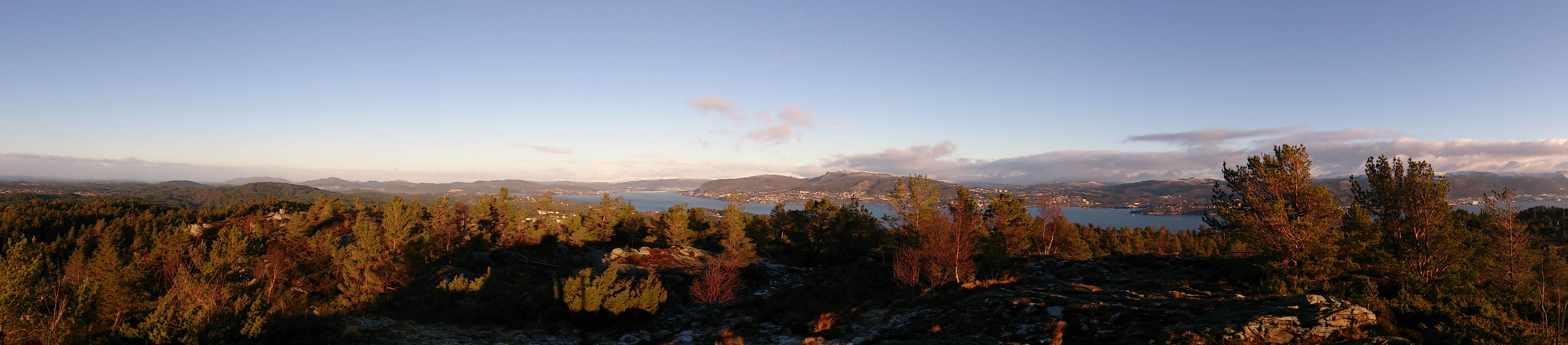 Started by taking the bus to Florvågskiftet and walking east and then north along Bergheimsvegen for the start of the hike towards Storevarden . The trail was not marked, but easy to follow. Storevarden provided excellent views towards the mainland and the city center. Definitely worth a visit. I continued north over Langafjellet and crossed west in-between the two small lakes via a very muddy trail, and then followed the same trail all the way to Kolbeinsvarden . Nice views here as well, in all directions.
From the summit of Kolbeinsvarden I made the mistake of following the same trail back, for some reason missing the main trail going directly south from the summit. I noticed the mistake quickly though, and decided to try a shortcut to get back on track. This was harder than expected, and in the end I'm pretty sure >>>
Started by taking the bus to Florvågskiftet and walking east and then north along Bergheimsvegen for the start of the hike towards Storevarden . The trail was not marked, but easy to follow. Storevarden provided excellent views towards the mainland and the city center. Definitely worth a visit. I continued north over Langafjellet and crossed west in-between the two small lakes via a very muddy trail, and then followed the same trail all the way to Kolbeinsvarden . Nice views here as well, in all directions.
From the summit of Kolbeinsvarden I made the mistake of following the same trail back, for some reason missing the main trail going directly south from the summit. I noticed the mistake quickly though, and decided to try a shortcut to get back on track. This was harder than expected, and in the end I'm pretty sure >>>
Nattlandsfjellet to Haukeland Sykehus
- Datum:
- 18.12.2016
- Tourcharakter:
- Bergtour
- Tourlänge:
- 2:10h
- Entfernung:
- 7,4km
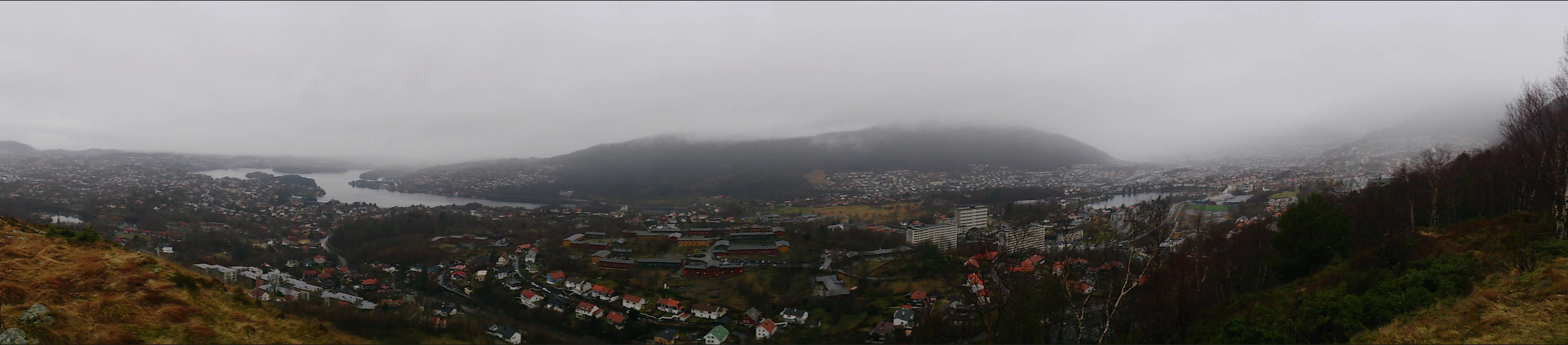 Took the bus to Kolstibotn and walked along the road up to Nattlandsfjellet for a quick trip to the trig marker indicated on the map for a better view than from the summit itself. I then continued along the road to Nordre Nattlandsfjellet for the start of the hike towards Ulriken, along the ridge passing by Orrehaugane before ending up at Haukeland Sykehus for the bus back to the city center. Overall, a nice hike, but in poor weather conditions with lots of rain and dense fog. Perhaps something to repeat in better weather.
Burdalsfjellet and Botlenipa
- Datum:
- 11.12.2016
- Tourcharakter:
- Bergtour
- Tourlänge:
- 2:16h
- Entfernung:
- 6,8km
 Started by taking the bus to Knarrevik and trying to locate the trail on the north side of Rv. 555 for the start of the hike. However, this turned out to be more difficult than expected, as I quickly found myself on the wrong side of a busy road with no zebra crossings to be found. I therefore ended up walking along the road towards Sotra, but in the end I gave up looking for a crossing and managed to find a short break in the traffic and finally managed to safely reach the other side of the road.
Next, I located a trail taking me to Storavatnet and then onwards to Burdalsfjellet . Even in quite dense fog, the trail was easy to follow and I quickly arrived at the summit for some nice atmospheric pictures. I continued along the trail towards the small piece of land connecting the two lakes of Storavatnet and >>>
Started by taking the bus to Knarrevik and trying to locate the trail on the north side of Rv. 555 for the start of the hike. However, this turned out to be more difficult than expected, as I quickly found myself on the wrong side of a busy road with no zebra crossings to be found. I therefore ended up walking along the road towards Sotra, but in the end I gave up looking for a crossing and managed to find a short break in the traffic and finally managed to safely reach the other side of the road.
Next, I located a trail taking me to Storavatnet and then onwards to Burdalsfjellet . Even in quite dense fog, the trail was easy to follow and I quickly arrived at the summit for some nice atmospheric pictures. I continued along the trail towards the small piece of land connecting the two lakes of Storavatnet and >>>
Håøytoppen
- Datum:
- 10.12.2016
- Tourcharakter:
- Bergtour
- Tourlänge:
- 3:07h
- Entfernung:
- 11,3km
 Started by talking the bus to Flatøy and walking along the main road (on a nice wide sidewalk) to a parking lot next to E39 where I found the hiking signs to Håøytoppen . I then followed a varied and easy to follow trail to the southern end of Håøyna, where the trail turned into a gravel road that lead me all the way to the summit of Håøytoppen.
I spent some time at the top exploring the different views before taking (more or less) the same route back to the starting point of the hike. There I figured out that I had to wait quite a while for the bus, so I decided to rather extend the hike by also crossing Nordhordlandsbroen and take the bus from there.
Started by talking the bus to Flatøy and walking along the main road (on a nice wide sidewalk) to a parking lot next to E39 where I found the hiking signs to Håøytoppen . I then followed a varied and easy to follow trail to the southern end of Håøyna, where the trail turned into a gravel road that lead me all the way to the summit of Håøytoppen.
I spent some time at the top exploring the different views before taking (more or less) the same route back to the starting point of the hike. There I figured out that I had to wait quite a while for the bus, so I decided to rather extend the hike by also crossing Nordhordlandsbroen and take the bus from there.
Håmanen and Sandviksfjellet
- Datum:
- 03.12.2016
- Tourcharakter:
- Bergtour
- Tourlänge:
- 3:32h
- Entfernung:
- 12,8km
 Started from Lønborg and used the new gravel road (Hellemyrstien) on the eastern side of Eidsvågsfjellet to get to Langevatnet and then Munkebotsvatnet. Here we took a short detour to Håmanen . No views from the summit itself, but there are nice views to the southwest if moving west of the the summit.
After descending from Håmanen we continued up the gravel road to Storevatnet, where we took another short detour, this time to reach the top of Sandviksfjellet , where the views were very limited due to fog. Same route back to Lønborg.
Started from Lønborg and used the new gravel road (Hellemyrstien) on the eastern side of Eidsvågsfjellet to get to Langevatnet and then Munkebotsvatnet. Here we took a short detour to Håmanen . No views from the summit itself, but there are nice views to the southwest if moving west of the the summit.
After descending from Håmanen we continued up the gravel road to Storevatnet, where we took another short detour, this time to reach the top of Sandviksfjellet , where the views were very limited due to fog. Same route back to Lønborg.
Sjurstonipa and Lydarnipa
- Datum:
- 27.11.2016
- Tourcharakter:
- Bergtour
- Tourlänge:
- 3:40h
- Entfernung:
- 11,4km
 Another hike in Ytre Arna. This time the main goal being Ulvaberget . I started by taking the bus to Gamsevegen and following the gravel road that leads towards Sjurstonipa . After getting to the summit of Sjurstonipa I continued south to the old discontinued shooting range at the southern end of Stemmevatnet, and from there followed the trail towards Ulvaberget. The views from the summit were very nice, with steep cliffs down to Spåkevatnet, which was a bit surprising as the climb to the top was not particularly long or steep.
From the summit of Ulvaberget I decided to try walking along the western side of Spåkevatnet to get back to the road to the north of Gaupåsvatnet. I was therefore encouraged when seeing signs indicating that this was indeed an option. However, after following the trail along the lake for >>>
Another hike in Ytre Arna. This time the main goal being Ulvaberget . I started by taking the bus to Gamsevegen and following the gravel road that leads towards Sjurstonipa . After getting to the summit of Sjurstonipa I continued south to the old discontinued shooting range at the southern end of Stemmevatnet, and from there followed the trail towards Ulvaberget. The views from the summit were very nice, with steep cliffs down to Spåkevatnet, which was a bit surprising as the climb to the top was not particularly long or steep.
From the summit of Ulvaberget I decided to try walking along the western side of Spåkevatnet to get back to the road to the north of Gaupåsvatnet. I was therefore encouraged when seeing signs indicating that this was indeed an option. However, after following the trail along the lake for >>>
