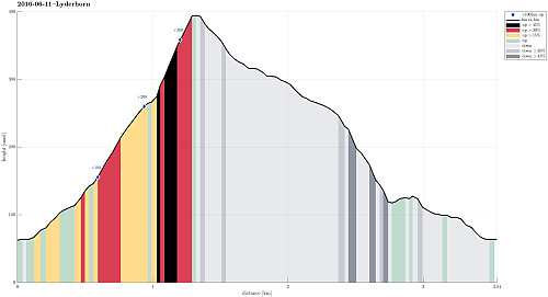
Lyderhorn from Kjøkkelvik (11.06.2016)

Geschrieben von HHauser (Helwig Hauser)

| Startpunkt | Kjøkkelvik school (60m) |
|---|---|
| Endpunkt | Kjøkkelvik school (60m) |
| Tourcharakter | Bergtour |
| Tourlänge | 1h 30min |
| Entfernung | 3,5km |
| Höhenmeter | 349m |
| GPS |
|
| Besteigungen | Lyderhorn (396m) | 11.06.2016 |
|---|---|---|
| Besuche anderer PBE | Lyderhornhytten (lokalitet) (396m) | 11.06.2016 |

Trip Summary
We started from nearby Kjøkkelvik school, ascending via Lyderhornslien into Olderdalen. The path follows a nice ridge up (first into southeastern direction, towards Små-Lyderhorn), before turning (steeply) left, right after reaching the saddle point. From there, it's then directly up to Lyderhorn (in northern direction). From the top of Lyderhorn, we continued northwards (and down). We first thought to step down a path to the upper end of Lyderhornslien, which is somehow parallel to the one we took up (a little further north). After having passed by the entry point to this path (which always is a little tricky to find!), we continued and decided to take the next path down (forking off to the left, west, right before getting to Høgenuten). This path leads to the upper end of Nedbergelien. Instead of walking down Nedbergelien, we went left, south, and connected to Krabbedalen on a small path that continues from Nedbergelien. From there, it is then straight-forward to connect to Lyderhornlien (one right-turn of Kjøkkelvikbrekkene) is connected with a left-turn of Lyderhornlien for those, who walk. The last meters down, then, were similar to what we started with. Good to know different routes up and down Lyderhorn! :-)
Photos
Selected photos are available as Google photo album.
Useful Resources
See also the related FB-page Hiking around Bergen, Norway.
Web page WestCoastPeaks.com provides useful information about Lyderhorn and Ørnafjellet
and also Petter Bjørstad has a page about Lyderhorn.
On Bergentopp 200 there is a page (in Norwegian) about Lyderhorn.


Benutzerkommentare