Boeses Weibl from Lucknerhaus (15.07.2016)

| Start point | Lucknerhaus (1,918m) |
|---|---|
| Endpoint | Lucknerhaus (1,918m) |
| Characteristic | Hillwalk |
| Duration | 7h 00min |
| Distance | 15.4km |
| Vertical meters | 1,413m |
| GPS |
|
| Ascents | Böses Weibl (3,119m) | 15.07.2016 |
|---|---|---|
| Visits of other PBEs | Lucknerhaus (1,918m) | 15.07.2016 |

Trip Summary
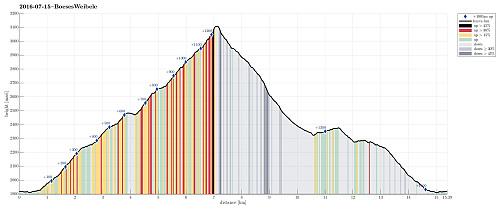
We started from Lucknerhaus and went first via Nigglalm to Oberfigeralm. From there, we continued into the valley of the Peischlachbach, heading for Peischlachtörl at 2484m. There, we turned right (into southern direction) and started the actual ascent to the Boeses Weibl. The ridge leads up to the Tschadinsattel, from which it only is several minutes to the top of the Boeses Weibl. Unfortunately, we could not reach the top, while the weather was still OK---so we had to imagine the great views from the top of this mountain. We then descended along the same route until we came to a place (on the ridge), where a path to the west, towards Tschadinalm, separates (at about 2760m sea-level). We then continued towards Tschadinalm (at about 2325m sea-level), before turning right again and connecting to Matoitzalm in Peischlachbachtal, where we met the path, again, which we had taken up from Lucknerhaus. From there, we returned as we came up there, earlier. All in all, this hike up Boeses Weibl is quite doable, even though one get into high apline regions (Boeses Weibl is 3119m above the sea). Better weather would have increased the pleasure to do this hike even more! :-)
Photos
Selected photos are available as Google photo album.
Useful Resources
See also the related FB-page Hiking around Bergen, Norway.
The German Wikipedia has a page about the Boeses Weibl.
Web page Hikr.org describes a similar hike up to the Boeses Weibl and also web page Glocknerspur.at describes a similar hike up to the Boeses Weibl.
Web page Almenrausch.at describes a similar tour up to the Boeses Weibl and also web page Tourenfex.at describes a similar tour.
Web page Bergfex.at describes a tour up to the Boeses Weibl from the other side.


User comments