Archive - Date
Archive - Activity
-
Bike trip (110)
- Bike trip - mixed (35)
- Bike trip - road (5)
-
Other trip (1)
- Kayaking (1)
-
Other winter trip (4)
- Snowshoe trip (4)
- Ski trip (3)
- Trip by foot (703)
Archive - Geography
Peakbook-Friends


Collected lists
-
Bergen ≥ 50m pf. og ≥ 100 m.o.h.
(87/89)
 97%
97% -
Most dominating tops of the Bergen peninsula
(68/75)
90%
-
Utvalgte topper og turmål i Bergen
(299/339)
88%
-
Alle topper i Bergen
(344/392)
87%
-
Opptur Bergen
(99/113)
87%
-
De syv fjell rundt Bergen
(6/7)
85%
-
Sund ≥ 50m pf.
(14/18)
77%
-
Os ≥ 50m pf.
(25/34)
73%
-
Søyler (fastmerker) i Bergen
(66/100)
66%
-
Fjell ≥ 50m pf.
(21/32)
65%

From Weissenbach to the Haleswiessee and back
- Date:
- 04.07.2005
- Characteristic:
- Hike
- Duration:
- 4:00h
- Distance:
- 6.2km
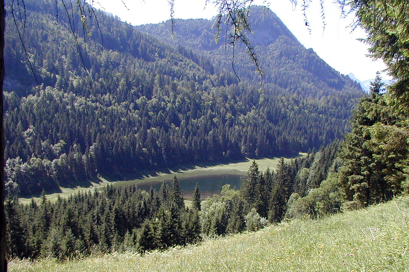 We started from the Waldsiedlung in Weissenbach am Attersee and ascended on the southern side of the valley until we came to an intermediate height, almost meeting Loidlbach, which nearby takes a turn to the left and towards the Burgaubach further down (west of Weissenbach). Instead of continuing further up to one of the nearby mountains, we instead crossed a saddle to get further towards Haleswiessee, a nice little lake, surrounded by the mountains around it. We enjoyed some time up there, before we returned, basically along the same path that we had taken up first.
See also the related FB-page Hiking around Bergen, Norway .
We started from the Waldsiedlung in Weissenbach am Attersee and ascended on the southern side of the valley until we came to an intermediate height, almost meeting Loidlbach, which nearby takes a turn to the left and towards the Burgaubach further down (west of Weissenbach). Instead of continuing further up to one of the nearby mountains, we instead crossed a saddle to get further towards Haleswiessee, a nice little lake, surrounded by the mountains around it. We enjoyed some time up there, before we returned, basically along the same path that we had taken up first.
See also the related FB-page Hiking around Bergen, Norway .
Kleiner Schoberstein from Weissenbach
- Date:
- 02.07.2005
- Characteristic:
- Hillwalk
- Duration:
- 3:00h
- Distance:
- 4.4km
 We started from Weissenbach am Attersee and ascended via the western ridge of the Höllengebirge up to Schober (Kleiner Schoberstein). Clearly, this is a nice (and not so long) hill-walk for those, who are enjoying some good time at lake Attersee!
See also the related FB-page Hiking around Bergen, Norway .
We started from Weissenbach am Attersee and ascended via the western ridge of the Höllengebirge up to Schober (Kleiner Schoberstein). Clearly, this is a nice (and not so long) hill-walk for those, who are enjoying some good time at lake Attersee!
See also the related FB-page Hiking around Bergen, Norway .
Höllengebirge with Alberfeldkogel
- Date:
- 27.06.2005
- Characteristic:
- Hike
- Duration:
- 5:00h
- Distance:
- 5.1km
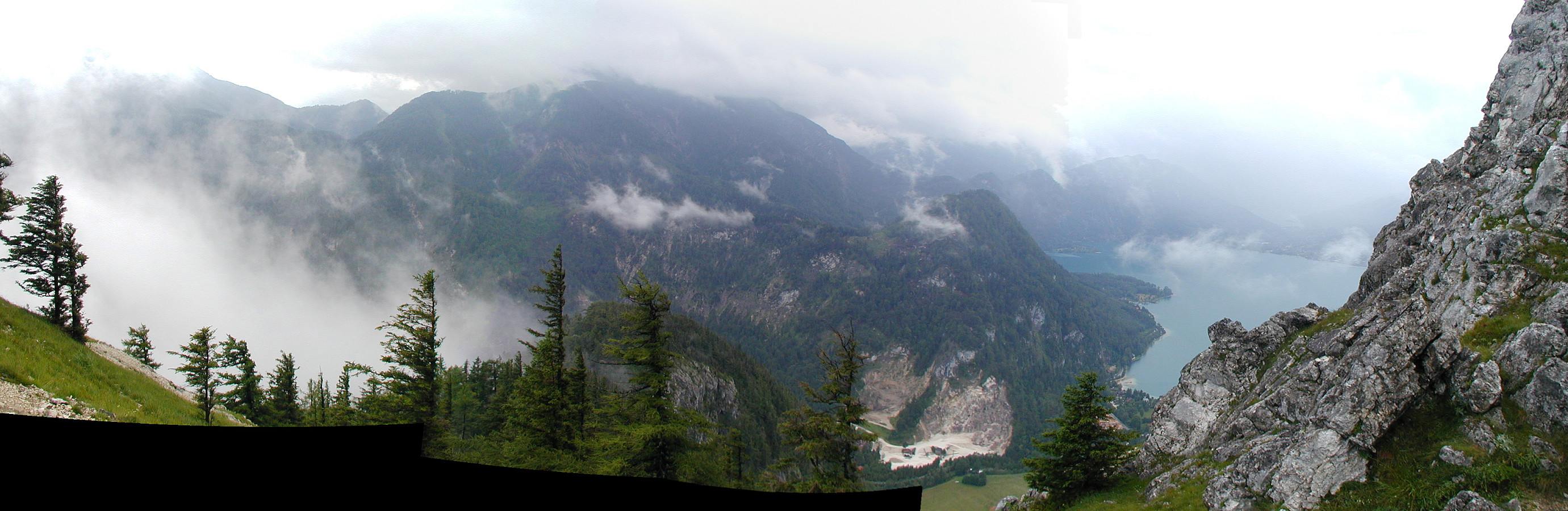
 We took the car to Ebensee at the lake Traunsee and then the cable car, which swiftly lifted us up to Feuerkogel 1575mosl! From there, we first walked "along the edge" (Höllengebirge falls off quite steeply in northern direction there, offering amazing views of the beautiful Salzkammergut, in particular with Traunsee etc.). This way, we made it to Alberfeldkogel, from which we enjoyed a wonderful view (mostly in northern direction). The weather was just so and so and due to the height it clearly was not very warm. We then made a round back to the cable car, hiking a little more "inlands". It was fun to also explore the still remaining patches of old snow (in end of June!).
More about related information on the web page of the cable car to Feuerkogel .
See also the related FB-page Hiking around Bergen, Norway .
We took the car to Ebensee at the lake Traunsee and then the cable car, which swiftly lifted us up to Feuerkogel 1575mosl! From there, we first walked "along the edge" (Höllengebirge falls off quite steeply in northern direction there, offering amazing views of the beautiful Salzkammergut, in particular with Traunsee etc.). This way, we made it to Alberfeldkogel, from which we enjoyed a wonderful view (mostly in northern direction). The weather was just so and so and due to the height it clearly was not very warm. We then made a round back to the cable car, hiking a little more "inlands". It was fun to also explore the still remaining patches of old snow (in end of June!).
More about related information on the web page of the cable car to Feuerkogel .
See also the related FB-page Hiking around Bergen, Norway .
Steinwandklamm and Rudolf Decker Steig
- Date:
- 15.05.2005
- Characteristic:
- Hike
- Duration:
- 4:00h
- Distance:
- 2.6km
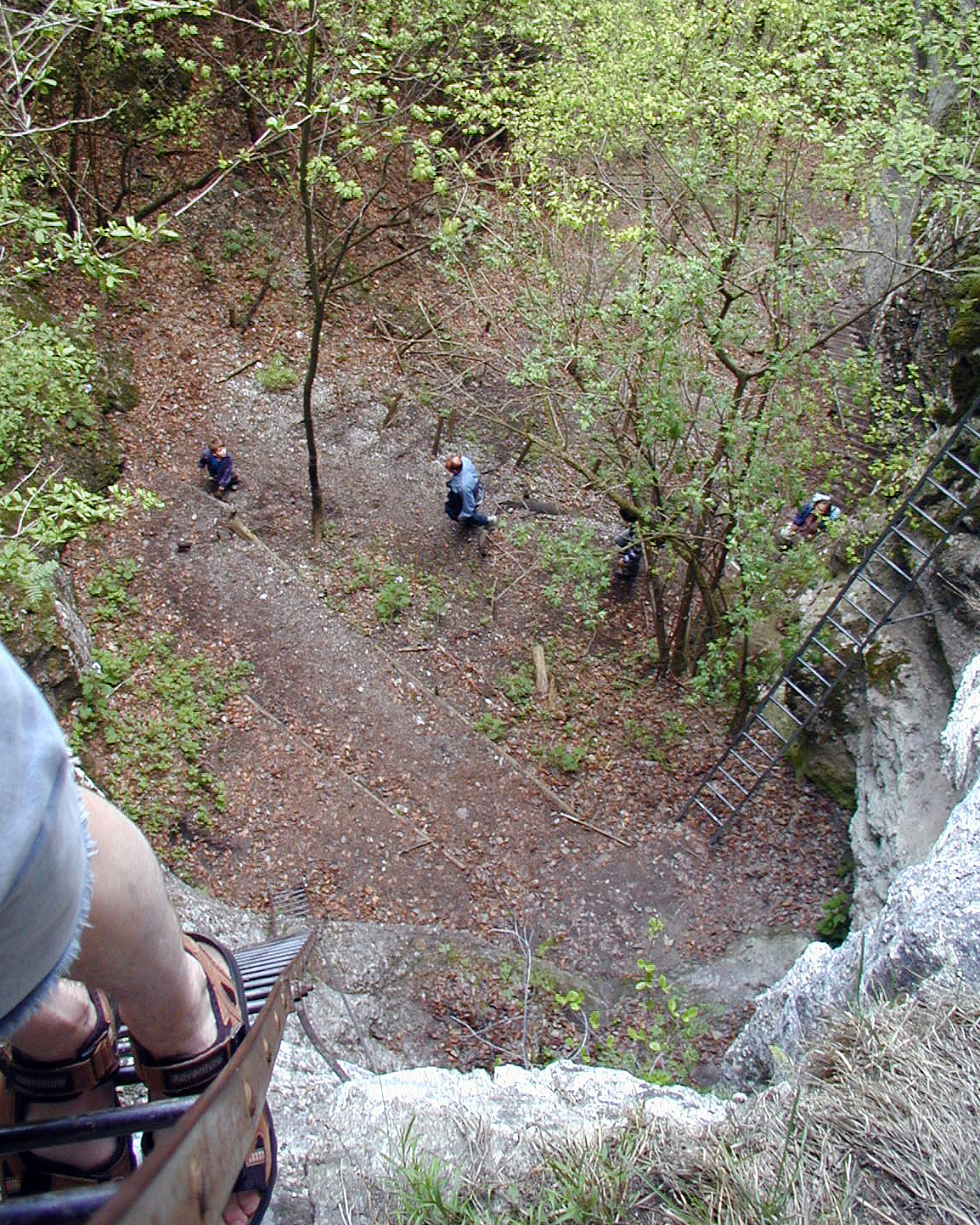 We took the car via Weissenbach an der Triesting and Schromenau into the Ruschhofbach-valley and in there to the very end of the road, where one can enter the impressive Steinwandklamm at its lowest point. We then stepped through the wild gorge until we came to the point, where the Rudolf Decker Steig leaves to the left. In order to follow this quite wild track, one needs to choose between to ladders to start with. If you are afraid of heights, then likely it is better to continue through the gorge and ascend to the top from further behind. The higher of these two ladders brings on up to a point in the cliff wall, where one enters a cave in the rock, through which the track continues. Following more ladders, stairs, and caves (among them the Türkenloch), one eventually gets out of the gorge and to >>>
Visiting Die Wüste Mannersdorf
- Date:
- 03.04.2005
- Characteristic:
- Hike
- Duration:
- 4:00h
- Distance:
- 4.4km
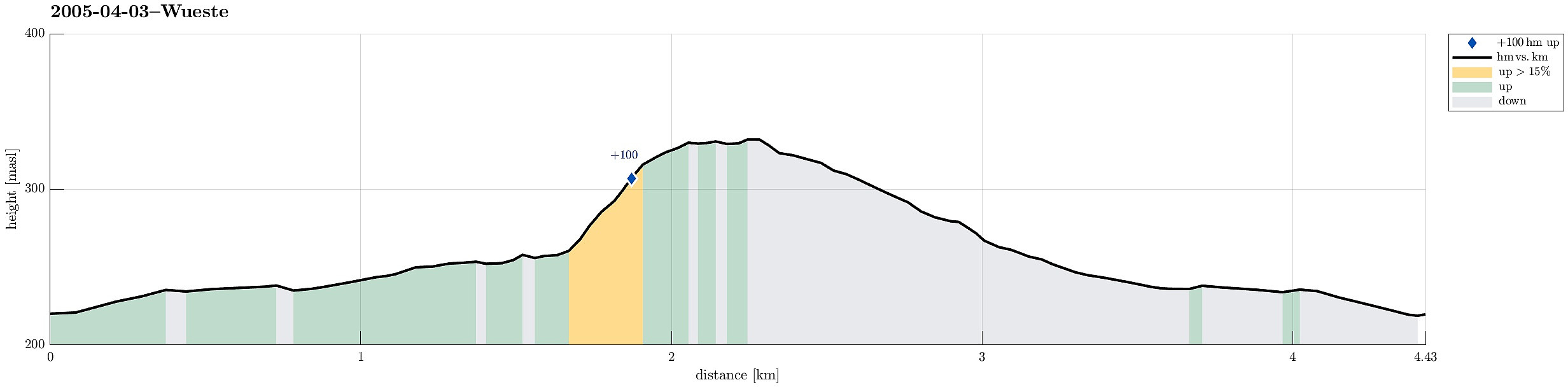 We took the car to the northwestern edge of Leithagebirge, between Mannersdorf and Hof am Leithaberge, where one find the entry point for the Wüste , a nice place to visit, in particular also with kids. We first walked into the area along the Arbach, finding the alley, which leads up to St. Anna in der Wüste, previously a monestary. After some good time there, we continued (again along the Arbach) to a point, from which we then ascended to Schlossberg with its impressive Ruine Scharfeneck on top. After exploring these ruins, we continued along the height in southern direction, before we turned right (back towards St. Anna). On the way back, we also came by the Joachim Eremitage. Eventually, we returned to the car, passing by St. Anna in der Wüste once again. This place, Die Wüste Mannersdorf , really is recommended >>>
Biking through the Alps 6: Pens-Innsbruck
- Date:
- 30.08.1998
- Characteristic:
- Bike trip
- Duration:
- 7:30h
- Distance:
- 81.7km
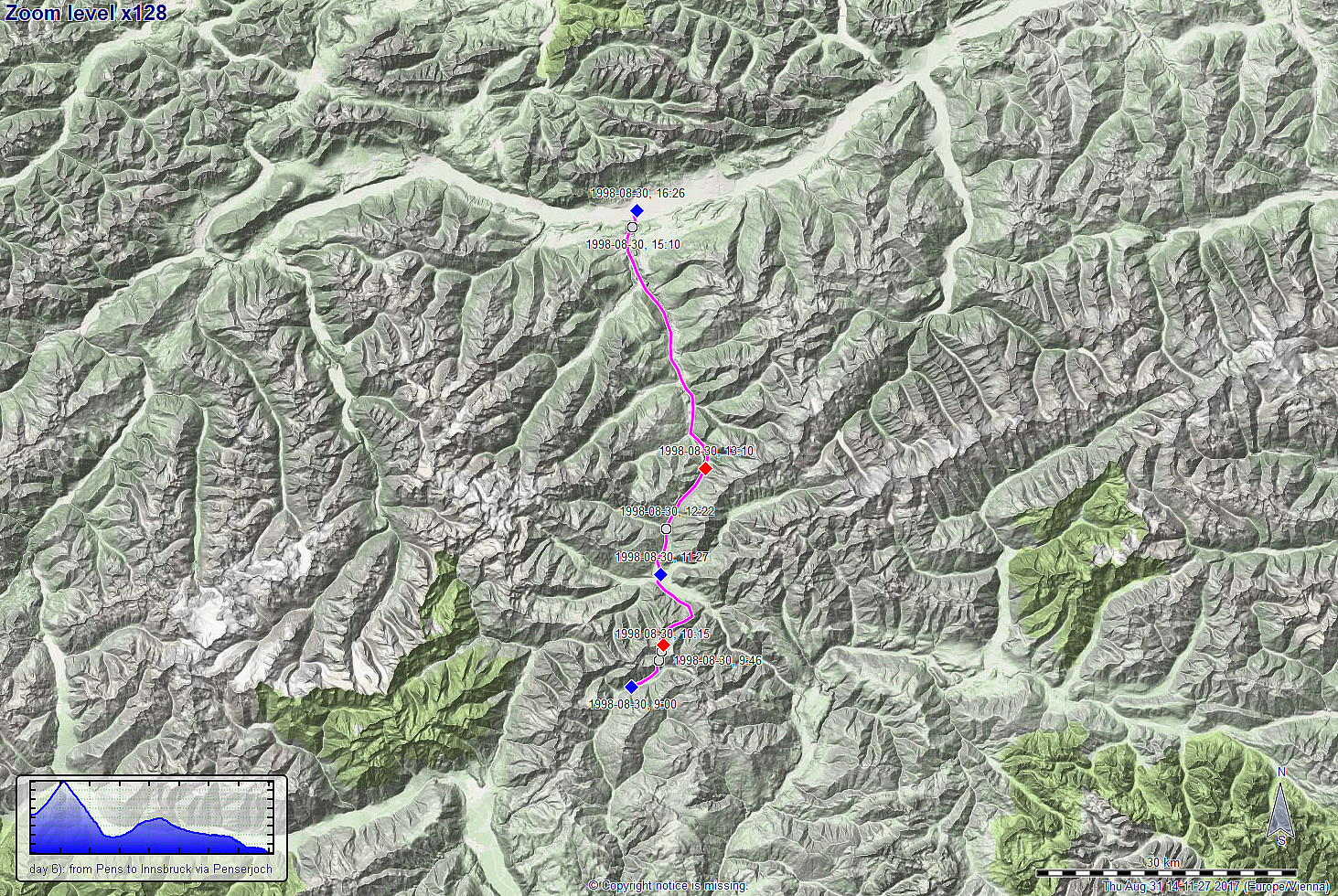 The last, sixth day of this one-week bike-trip through the Alps in Südtirol should bring us over the impressive Penserjoch (at 2200mosl) and then, via Sterzing and the Brenner, to Innsbruck, where we had planned to conclude our trip. We first cycled the roughly 800 height-meters up to Penserjoch in a little less than two hours, enjoying our last pass over 2000mosl, before continuing further northwards. What followed, was a long and fast descent down to Sterzing (at about 930mosl), from where we headed further towards the Brenner (minor pass at about 1365mosl). This brought us also back to Austria. From there, we basically "just" did a long descent towards Innsbruck (about 40km), where we arrived at about 4pm in the afternoon. All in all, this six days long bike trip through >>>
Biking through the Alps 5: Kastelruth-Pens
- Date:
- 28.08.1998
- Characteristic:
- Bike trip
- Duration:
- 8:15h
- Distance:
- 68.4km
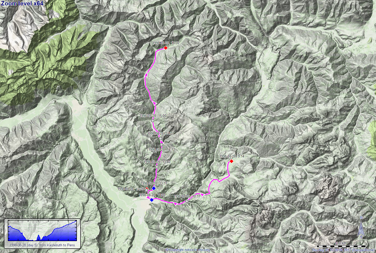 Day 5 of this multi-day bike-trip through the Alps in Südtirol should bring us first to Bozen and then, from there, northwards into the vicinity of the Penserjoch, another big goal on this trip. Cycling mostly downwards, we rapidly approached Bozen from Kastelruth and found ourselves as low as 275mosl there! :-) Clearly, we had no plans to stay in the low-lands for long, so we continued towards the north after a short break. Due to a little mishap, reading the map, we first took a road, however, which did not really bring us into the right valley! In fact, we really had to get down (almost all the way), again, before we could change to the right route, "dropping" about one hour for this detour. Then, however, everything was clear and we started a long ascent (not so very steep, >>>
Biking through the Alps 4: Caprile-Kastelruth
- Date:
- 27.08.1998
- Characteristic:
- Bike trip
- Duration:
- 11:30h
- Distance:
- 66.5km
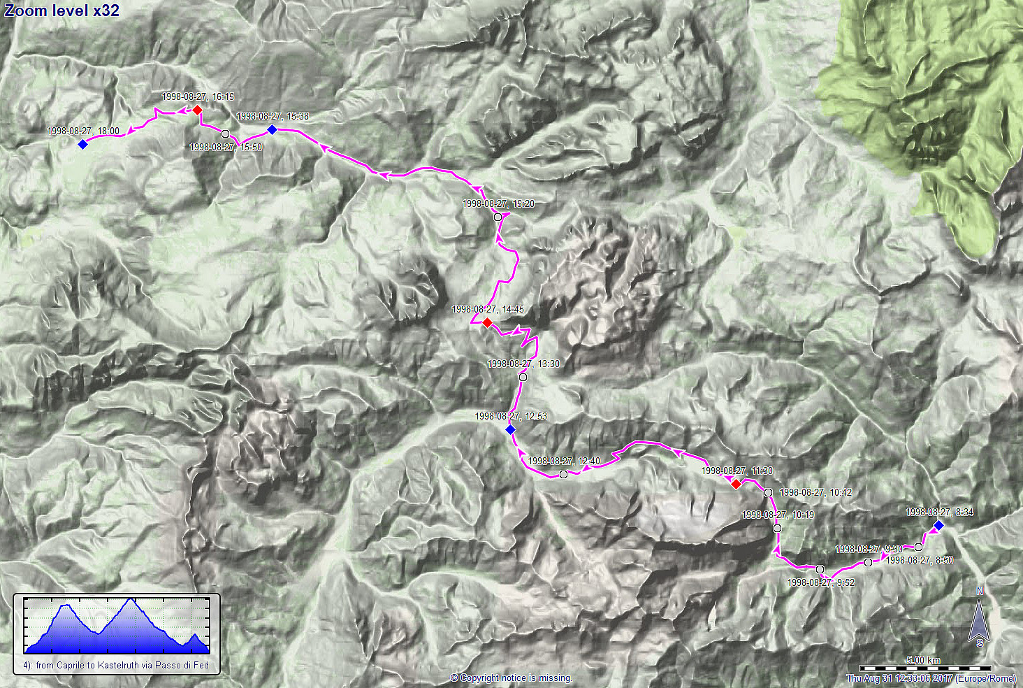 Day 4 of this multi-day bike-trip through the Alps in Südtirol should include two major passes, i.e., Passo di Fedaia (2060mosl) and Sellajoch (2245mosl), with a significant dip in between! We started from Caprile at about 8:30 in the morning, heading straight towards Passo di Fedaia in the west. About three hours later, we arrived at the saddle, right next to the majestic Marmolada in the south. On the other side, towards west, we then descended very quickly to Canazei (at about 1500mosl), reaching top-speed of over 60km/h (lots of fun, but also risky). From there, we started our biggest ascent on this day (to Sellajoch) and about two hours later, we actually arrived on this high saddle in amazingly beautiful mountain landscape! What followed was mostly a long descent, first into the >>>
Biking through the Alps 3: Misurina-Caprile
- Date:
- 26.08.1998
- Characteristic:
- Bike trip
- Duration:
- 10:30h
- Distance:
- 51.8km
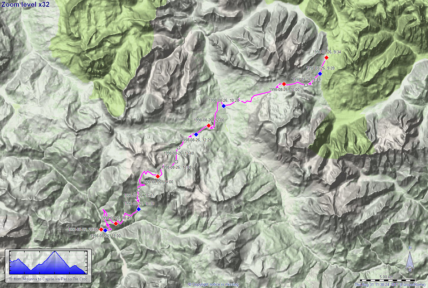 Day 3 of this multi-day bike-trip through the Alps in Südtirol should bring us to Cortina d'Ampezzo and then up to a major saddle (Passo Giau at 2220mosl). In order to get to Cortina, we first needed to traverse another (smaller) saddle, i.e., Passo Tre Croci (at 1795mosl). The ride down to Cortina was then fast and exciting with top-speeds over 60km/h! From there, we started our big ascent on this day (about 1000hm up!) to reach Passo Giau about 3.5 hours later. Getting up to high altitudes in this terrific mountain landscape of the Alps was exactly what we were heading for, so we really enjoyed this (even though is certainly is strenuous to cycle many height-meters up, in particular, when you are also carrying all your luggage for several days). After a long and fast descent from Passo >>>
Biking through the Alps 2: Defereggen-Misurina
- Date:
- 25.08.1998
- Characteristic:
- Bike trip
- Duration:
- 9:00h
- Distance:
- 81.6km
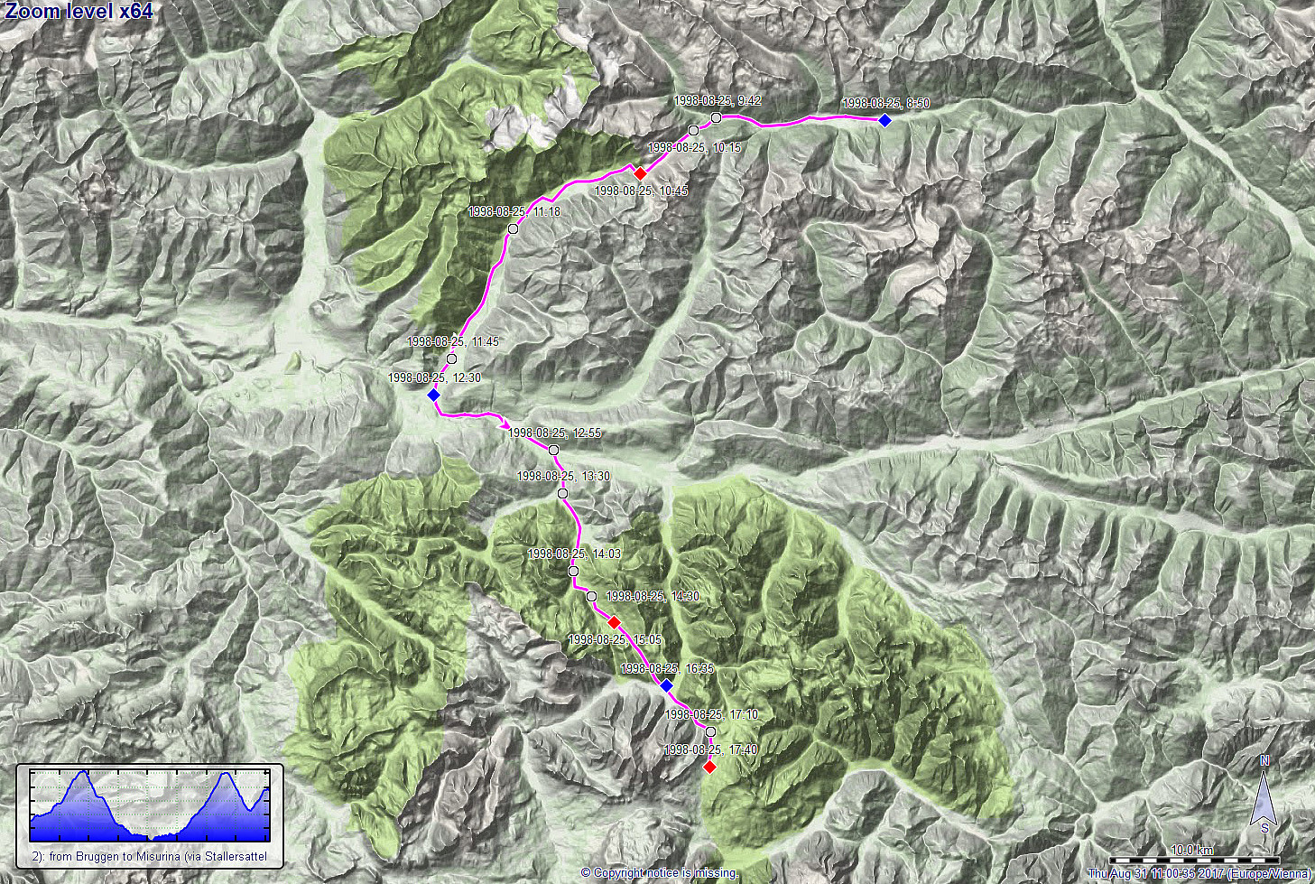 Day 2 of this multi-day bike-trip through the Alps should bring us from Austria to Südtirol, Italy. To do so, we had the plan to cross the 2040m high Stallersattel, coming from Defereggen. About two hours after having started in Bruggen (at about 1315mosl), we arrived at Stallersattel and enjoyed the beautiful mountain landscape there with satisfaction. :-) What followed, was a fast and long descent into the Antholzer valley (southwest of Stallersattel and already in Südtirol, Italy). At about noon-time, we were down at about 1000mosl, again, and turned left into the Pustertal (basically towards the east!). After a relatively short stretch in this comparably busy valley, we turned right, again (into southern direction), entering the Pragser valley with the plan to cycle up to Plätzwiesen >>>
