Archive - Date
Archive - Activity
-
Bike trip (110)
- Bike trip - mixed (35)
- Bike trip - road (5)
-
Other trip (1)
- Kayaking (1)
-
Other winter trip (4)
- Snowshoe trip (4)
- Ski trip (3)
- Trip by foot (703)
Archive - Geography
Peakbook-Friends


Collected lists
-
Bergen ≥ 50m pf. og ≥ 100 m.o.h.
(87/89)
 97%
97% -
Most dominating tops of the Bergen peninsula
(68/75)
90%
-
Utvalgte topper og turmål i Bergen
(299/339)
88%
-
Alle topper i Bergen
(344/392)
87%
-
Opptur Bergen
(99/113)
87%
-
De syv fjell rundt Bergen
(6/7)
85%
-
Sund ≥ 50m pf.
(14/18)
77%
-
Os ≥ 50m pf.
(25/34)
73%
-
Søyler (fastmerker) i Bergen
(66/100)
66%
-
Fjell ≥ 50m pf.
(21/32)
65%

Lyshornet
- Date:
- 26.09.2015
- Characteristic:
- Hillwalk
- Duration:
- 2:00h
- Distance:
- 8.9km
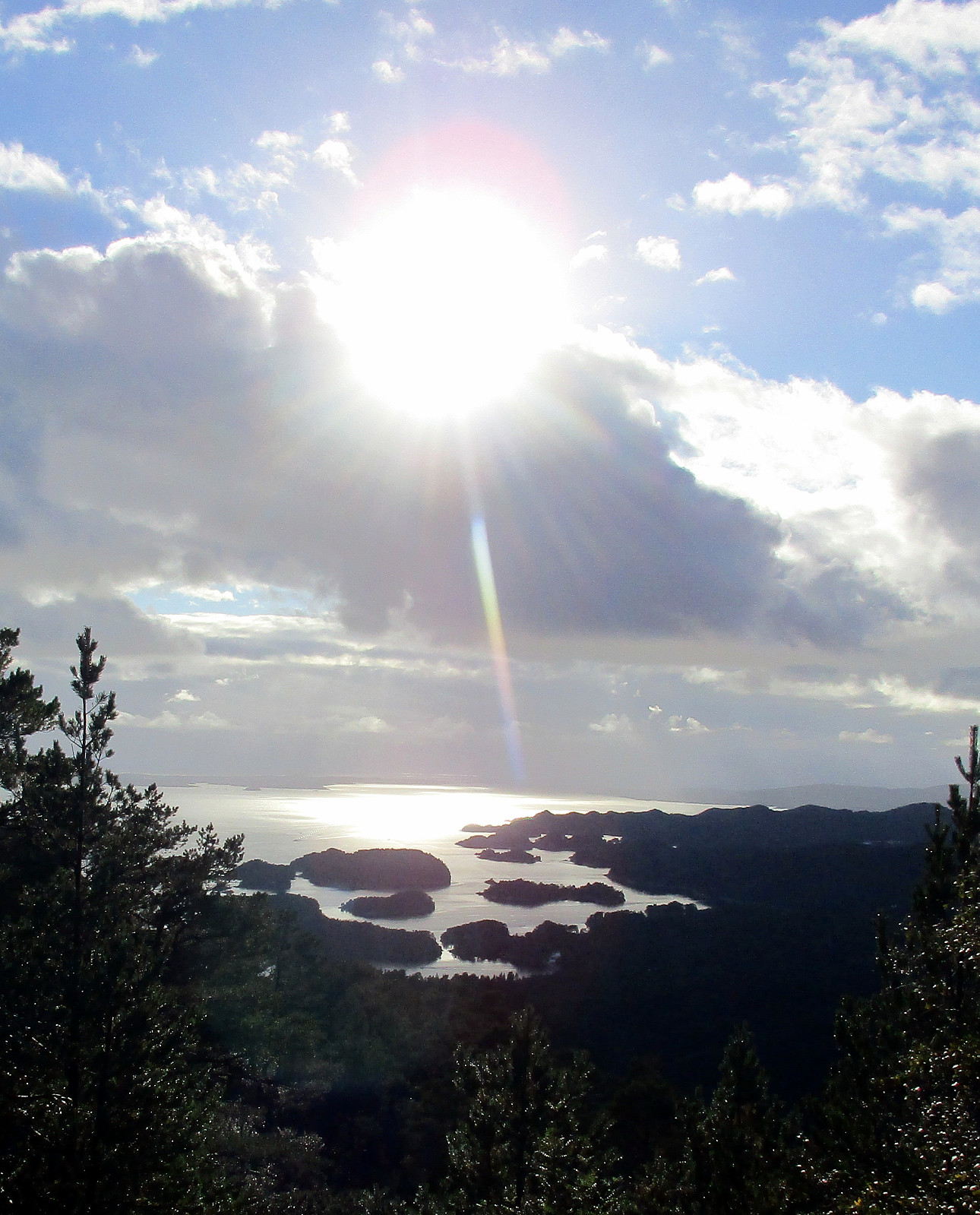 We parked right next to Pøyla/Kalvatræ and followed the gravel road that leads up to Svartavatnet/Ulvvatnet, first. That's an easy walk and one passes a point, maybe 200m before getting to the dam, where one can enjoy a really nice view over Lysefjorden! Once at the dam, one could continue on a smaller path (on the western side of Svartavatnet/Ulvvatnet), but we turned around and followed the gravel road that we had walked up, first. About half way back, right underneath Geithaugen in the west, and at about 145mosl, a nice path towards Lysehornet leaves (to the east). We followed this path (via Grønhovda) to Lysehornet and enjoyed the great views that one has from there. From Lysehornet, we descended via the other path, which leads (via Lyshornskaret) to the ruins of Lyseklosteret. >>>
Birje
- Date:
- 19.09.2015
- Characteristic:
- Walk
- Duration:
- 3:00h
- Distance:
- 12.9km
 Starting from a place near Øydvenstod, I first followed Osavegen up to the saddle towards Ulvik. There, I turned left, westwards, and ascended the few meters up to Håheim. From there, I followed the marked path -- in southwestern direction -- in order to get up to Åsen. It's not so clear, where the top actually is -- Åsen is well-covered with a forest and there are a number of ups and downs. I found my way to the antenna that is also seen from Ulvik and from there, via a simple path, down to Vattatveit. From there, I first followed the forest road, but when it turned left -- in eastwards directions -- I left it (to the right) and crossed Trånemyrhaugen (basically without any path). I crossed another forest road and continued (without path), this time up Vetlefurehaugen. On the other >>>
Lyderhorn
- Date:
- 17.09.2015
- Characteristic:
- Bike trip - mixed
- Duration:
- 2:00h
- Distance:
- 13.0km
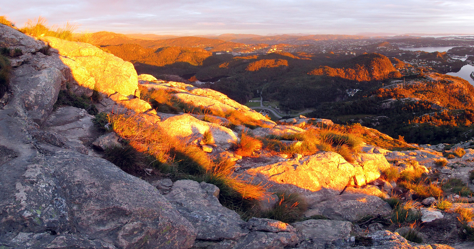 Quick excursion to Lyderhorn: First with the bike along Bjørgeveien and up to the new highway crossing near Liavatnet; then from there, walking, westwards and up in the direction of Grøvledalen (between Skarpafjellet and Lyderhorn). From the saddle, basically right underneath the power lines, then northwards and towards Lyderhorn. After a bit of up and down, the actual ascent to Lyderhorn is steep and nice. Down from Lyderhorn, I first followed the path that connects to Kjøkkelvikveien, further down, in the west of Lyderhorn, but before actually turning right in order to descend towards the west, I turned left (and towards the east), searching a connection to the path that I had taken up. I found my way, but mostly without a path, though. I followed that path I had take up (from Skarpafjellet) >>>
Store Kongshaugen & Harafjellet -- another bicycle round
- Date:
- 05.09.2015
- Characteristic:
- Bike trip - mixed
- Duration:
- 2:00h
- Distance:
- 24.7km
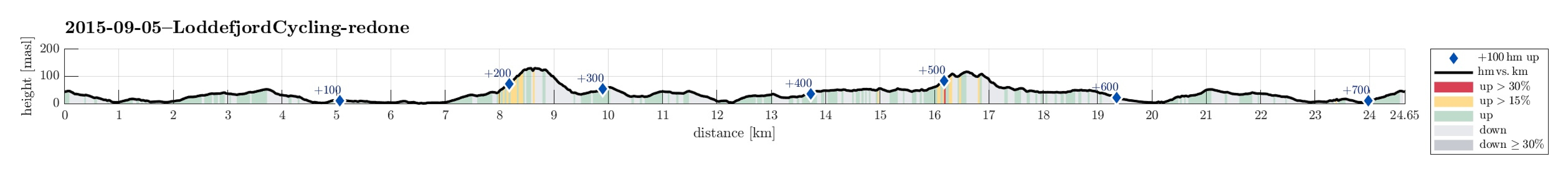 Let's get some fresh air in the nice weather -- even if there isn't much time! :-) On my bicycle and off towards the west! :-) In Loddefjord, I turned left (and southwards) and passed by Håkonsvern. Right afterwards and shortly before Mathopen, I turned right and started my short but (very) steep ascent to Store Kongshaugen -- what a name for a comparably small hill! :-) Even though not very high, one still can enjoy great views in all directions from its top. I returned down on the same steep and old road, before then continuing via Mathopen and Hilleren towards Alvøpollen. I followed the road around Småvatnet to the sports arena of Alvøen. There I found the connection to the path that stretches along Storavatnet. From this path, I made a short detour up Harafjellet (also a rather >>>
Feråsen, Sørås, and Skeisåsen -- an evening cycling round
- Date:
- 02.09.2015
- Characteristic:
- Bike trip - mixed
- Duration:
- 2:30h
- Distance:
- 28.3km
 After work, I needed some fresh air. After only few minutes of decision making, I got on my bicycle and started a quick round south of Fyllingsdalen. My first goal was Feråsen -- an easy-to-overlook small hill between Søreide, Steinsvik and Sandsli. I approached Feråsen from the east and ended up in a small street called Feråslia. I left my bicycle there and continued without. I found a simple trail that looked as if it would surround Feråsen. After having followed it somewhat half around Feråsen, I decided to simply ascend to the top -- with or without a path. While steep on this side, this worked easily and quickly, but I ended up on the neighboring small hill, right next to Feråsen. I changed over -- just to find out that the highest point is mostly part of a (private) garden. >>>
Fusafjellet
- Date:
- 30.08.2015
- Characteristic:
- Hillwalk
- Duration:
- 6:30h
- Distance:
- 17.4km
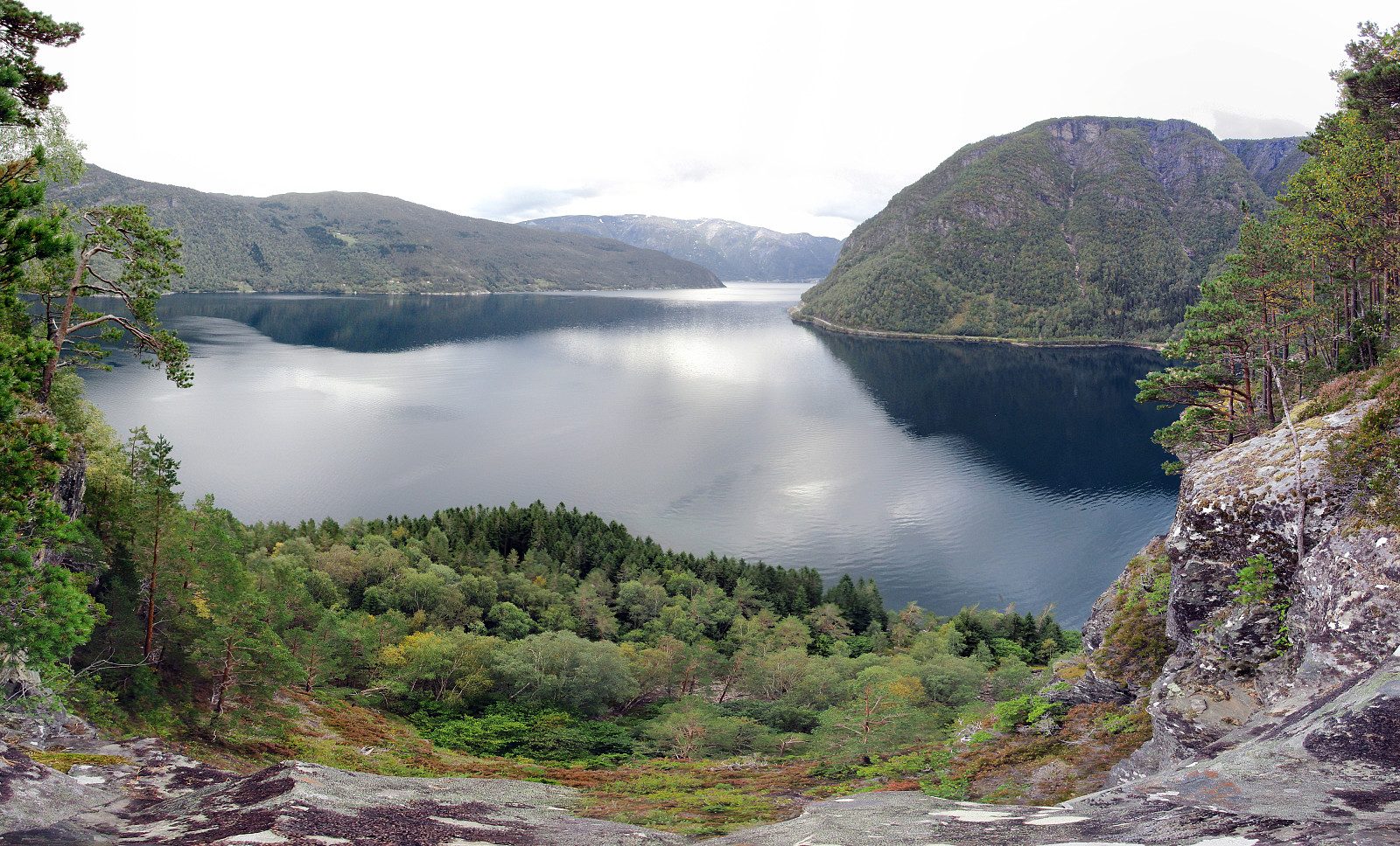
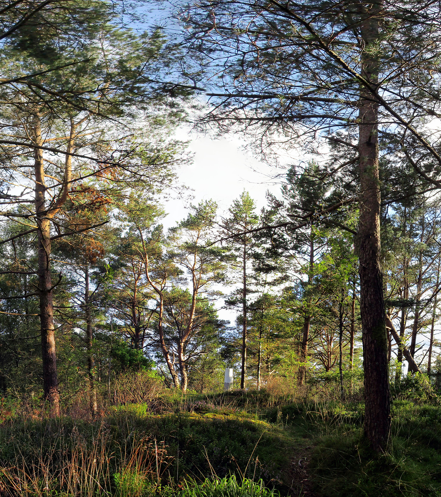
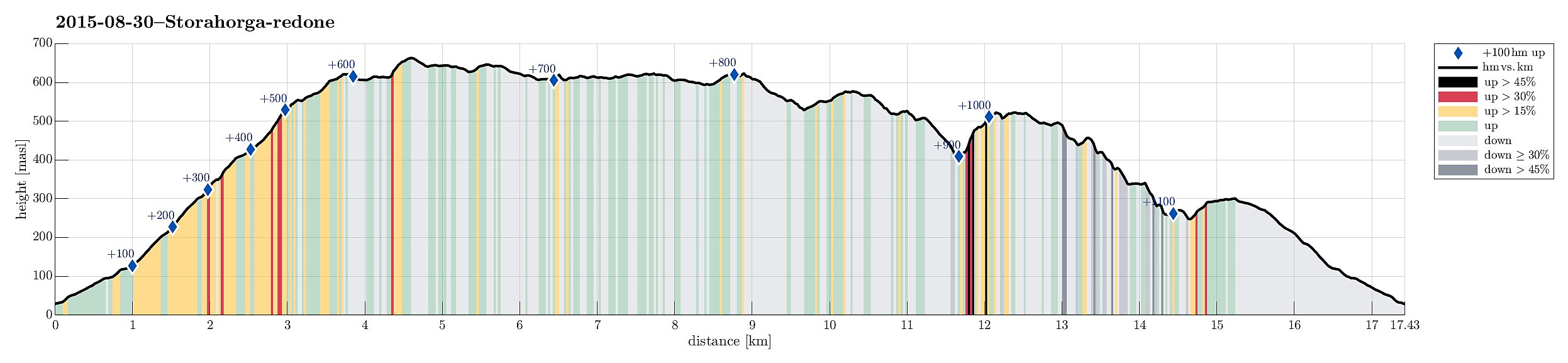 We took the ferry from Hattvik to Venjaneset and continued -- only a little less than 3km -- to Fusa. We parked the car right next to the street, where it crosses Sagelva and where a sign points towards the old postal path (gamle postveien) -- not at the least as also recommended by the page about Storehorga and Langenuen on WestCoastPeaks.com . We first went up a simple street called Øpstad (on the eastern side of Sagelva), which connects directly to a useful forest road, leading up the valley. At about 125mosl, we came to a road fork, continuing on the left, further up. At about 300mosl, another trail fork opens up for different alternatives -- we turned left, again, following the most direct route up to Fusafjellet (from there). Ascending a little further from there, we left the tree line below us and started to enjoy the many nice views that >>>
Kvigedalsegga
- Date:
- 23.08.2015
- Characteristic:
- Hillwalk
- Duration:
- 4:30h
- Distance:
- 8.3km
 Taking E16 from Bergen into the direction of Voss, we passed by Dale and turned left in Dalseid, shortly after. We then came through five very short tunnels along the fjord, before parking next to the road, right before Tretteneset. From there, we first walked up a forest road, which quickly ascends through Dalseidmarkåna. At about 260 masl, the forest road turns left and connects to Sæterdalen, while we continued in Dalseidmarkåna, right underneath the steep and high northern cliffs of Stølsberget (while it is easy to see, where to leave the forest road, it isn't 100% easy to then find the path further upwards -- keeping as close to the cliffs and as high above the stream as possible, on the southern side of it, seems to be a good rule to find the simple path, though). At about 400 >>>
Raudlifjellet
- Date:
- 22.08.2015
- Characteristic:
- Hillwalk
- Duration:
- 1:30h
- Distance:
- 4.6km
 A few hundred meters south of the gas station in Søfteland (along the E39), a narrow bridge leads over to Tømmernes. Behind there, right before crossing the little stream, which comes down there to enter Røkenesvatnet, we parked the car and walked into Botnabekken. We first tried to find a forest road on the northern side of the stream, but this was mostly forest terrain -- very wet, actually! About 100 height meters up in Tømmernesdalen, we crossed the stream, again, and continued -- steeply! -- towards the east (and up Raudlifjellet). This ascent was mostly without any path (at least not any visible path) -- still, this worked pretty nicely and we quickly arrived on a nice long ridge that would bring us to the top. Up on Raudlifjellet, we connected to the path that we had walked before (in 2014) and returned on it back to >>>
Storafjellet and the western end of Fanafjellet
- Date:
- 16.08.2015
- Characteristic:
- Hillwalk
- Duration:
- 3:00h
- Distance:
- 8.3km
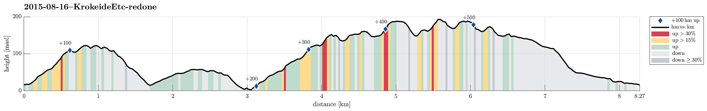 After having read Petter Bjørstad's page about Storafjellet , I was well prepared to get started. The day was very wet, but it was not cold -- so I enjoyed myself! :-) I found the path as described and ascended quickly to Storafjellet (funny name -- means "the big mountain" -- for a quite insignificant hill!). I continued further, descending towards Krokeide, coming down to a road called Svartefjorden. I did not follow this street, however, but descended all the way down to Eidet, where connected to the main road (Krokeidevegen) -- very near to the ferry pier! From there, I went back up (the main road) until I turned right into Austrevågen (quite on top of the small saddle over which the main road leads). I first did not find my way down to the bay Austrevågen, but after a short forth and back, I found it nonetheless >>>
Barmaneset on Algrøyna
- Date:
- 14.08.2015
- Characteristic:
- Hike
- Duration:
- 2:30h
- Distance:
- 7.0km
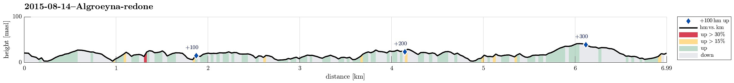 We parked on Nordre Øyavegen, right before getting close to the few houses on northern Algrøyna. From there, we first followed the road further (and down and upwards, again), before continuing on Kongvikvegen (to the west). After maybe 200m, a barn is on the left side with some signs that hiking tracks are leaving the road from there (down between the road and the barn through a narrow passage). Once this entry point is found, the rest of the tour is quite straight forward (or more in a round, actually). We walked out Barmaneset to the west, approaching Rognkallen and Langtrotten at the end of this peninsula (and Kungvika on our right). Once we came close to Krabbakeila, right between Rognkallen and Langtrotten, where the ocean waters get wild, even on a very calm day, we first approached >>>
