Archive - Date
Archive - Activity
-
Bike trip (110)
- Bike trip - mixed (35)
- Bike trip - road (5)
-
Other trip (1)
- Kayaking (1)
-
Other winter trip (4)
- Snowshoe trip (4)
- Ski trip (3)
- Trip by foot (703)
Archive - Geography
Peakbook-Friends


Collected lists
-
Bergen ≥ 50m pf. og ≥ 100 m.o.h.
(87/89)
 97%
97% -
Most dominating tops of the Bergen peninsula
(68/75)
90%
-
Utvalgte topper og turmål i Bergen
(299/339)
88%
-
Alle topper i Bergen
(344/392)
87%
-
Opptur Bergen
(99/113)
87%
-
De syv fjell rundt Bergen
(6/7)
85%
-
Sund ≥ 50m pf.
(14/18)
77%
-
Os ≥ 50m pf.
(25/34)
73%
-
Søyler (fastmerker) i Bergen
(66/100)
66%
-
Fjell ≥ 50m pf.
(21/32)
65%

Veten on Korsneset
- Date:
- 08.08.2015
- Characteristic:
- Hillwalk
- Duration:
- 1:45h
- Distance:
- 4.8km
 We parked on the parking place at Korsnesvegen (where the forest road norwards into Hagadalen departs). From there, we first followed the forest road northwards (for about 800m), before we found a well-marked path on the left. We followed this path, first westwards, before we then ascended to Veten in a larger turn (first northwards, then northeast). Right before reaching the top, it pays off to go a few steps to the left, westwards -- from there, one enjoyes a great view over Korsfjorden! From the top of Veten, the view over Fanafjorden is really great! We continued on the path that we had taken upwards, then downwards and back to the forest road (this part of this path is less clear, but still relatively easy to find). Back on the forest road, we continued northwards on it, down to >>>
Sveåsen from Kismul
- Date:
- 05.08.2015
- Characteristic:
- Hillwalk
- Duration:
- 2:00h
- Distance:
- 7.5km
 We parked at Kismul, right next to the small street, which leads around Kalandsvatnet, and right next to a partially legible note that informed (more than informs) that earlier the train would also stop there at Kismul (this explains, also, why there is a quite nice cycling path, in extended stretches parallel to the street), and walked up Kismulvegen first. Shortly after passing the last (of very few) houses, a forest road branches to the right and gently upwards. Following this road, one gets up to Svartevatnet with a very easy and relaxed walk. The vegetation next to the path is very varied and it is very enjoyable to walk this forest road! After first walking all the (not very long) way straight ahead towards Svartevatnet (at the lake, we clearly had the impression that the water level >>>
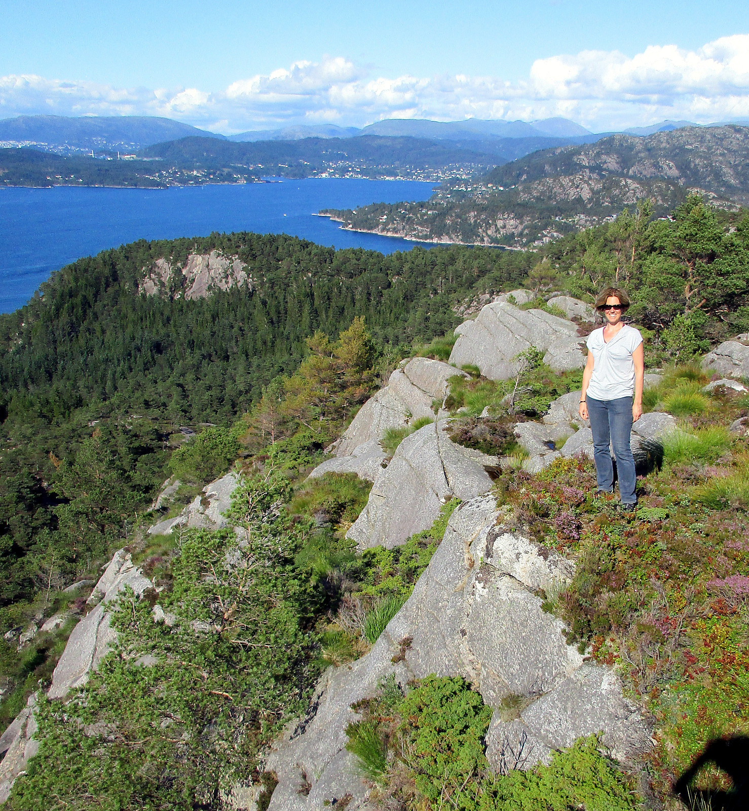
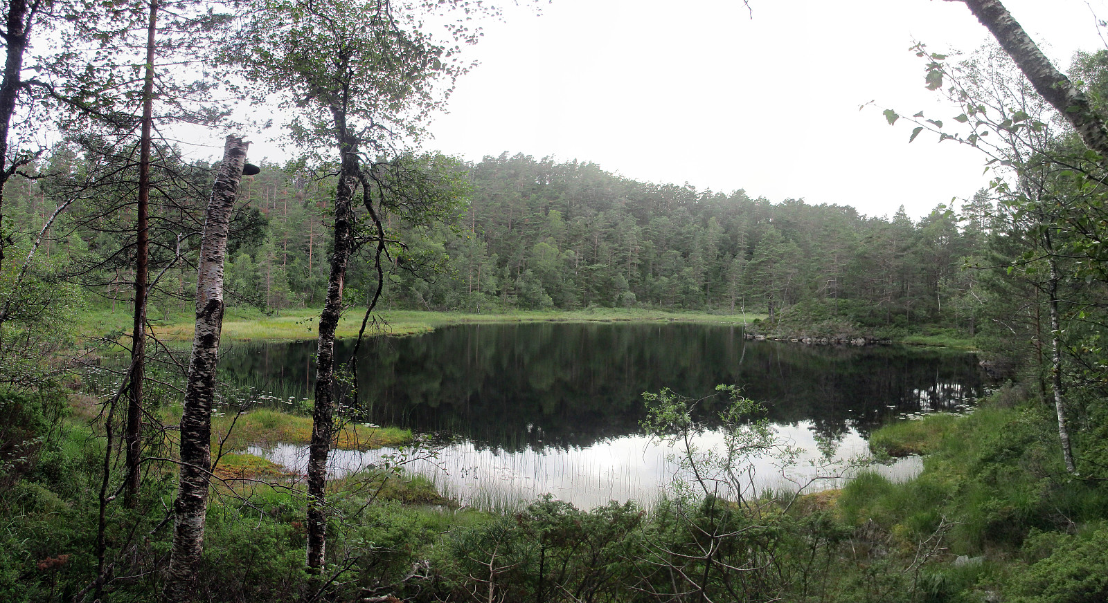
Sveningen from Midseterfjellet
- Date:
- 02.08.2015
- Characteristic:
- Hillwalk
- Duration:
- 6:15h
- Distance:
- 20.1km
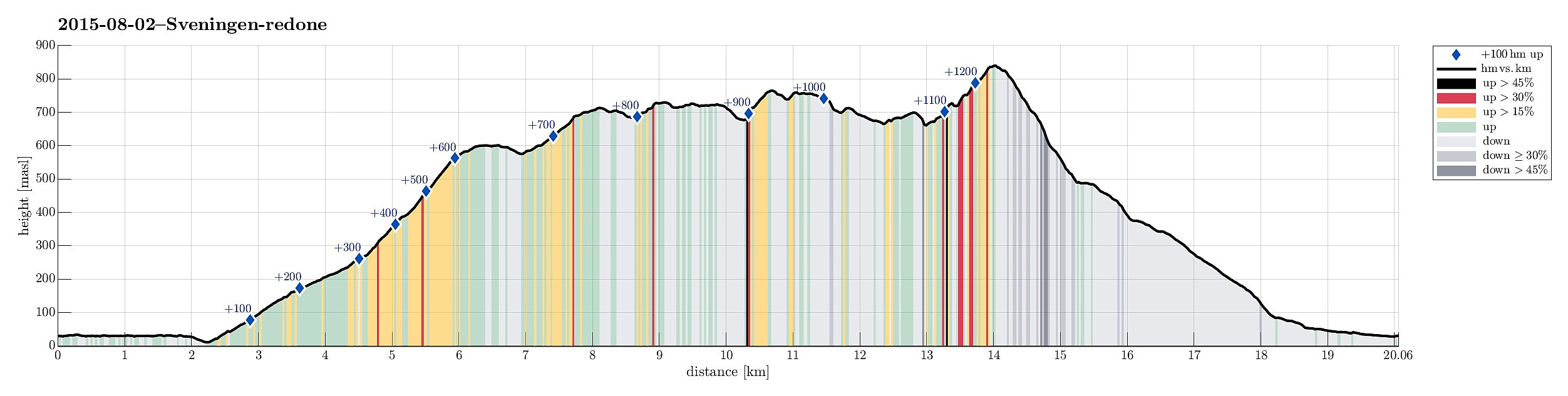 We parked our car at the end of Øvredalsvatnet (in Øvredalen) and walked back (southwards) along the lake to get to our starting point for the hike over the ridge (in Løyningdalen, right south of where Øvredalesvatnet "ends"). We then walked up the narrow road, which leads up to Midsætret, where a small number of houses assemble. From there, we first followed (for a short stretch, only) a forrest road, which leads mostly westwards, before then taking the hiking path that leads up to Midseterfjellet. First, we hiked in the forrest, but as soon as we left the trees behind, nice views opened, first mostly in western direction. The approximately 15 degrees Celsius were comfortable hiking weather -- in the beginning, however, it rained freshly melted snow, which brought the thought >>>
From Flaktveit to Fløyen
- Date:
- 28.06.2015
- Characteristic:
- Hillwalk
- Duration:
- 3:30h
- Distance:
- 14.1km
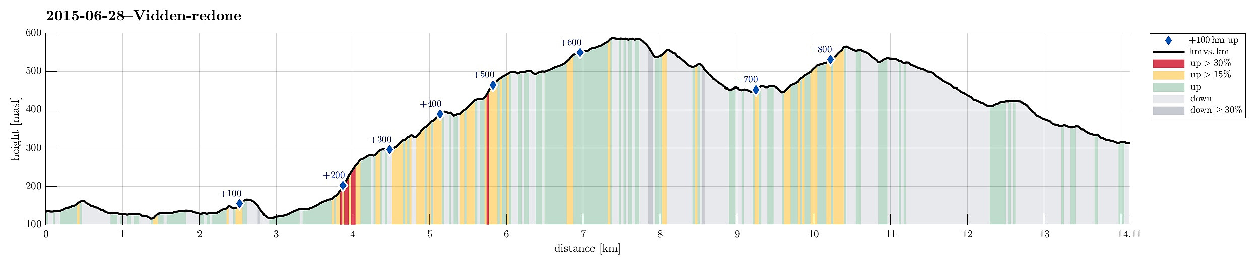 We took bus #4 to Flaktveit and left shortly before the last bus stop. First, we headed in the wrong direction (towards Ulsberglia), probably confused by the many swings, which the bus took, before approaching it final bus stop -- quite embarrassing! :-) But soon we found out, realigning our hike (now in southern direction!), heading towards Hjortland, first. Right after Søre Hjortland and shortly before Grønstølen, we found the path that leads up to the ridge high above Vinddalen. Once up there, one enjoys magnificent views, both towards west via Vinddalen and towards east! From there, heading mostly south, one gets up via Ørnafjellet to a longer ridge that leads to Vikinghytten -- a really nice part of this hike! From Vikinghytten, we headed towards Rundemannen, mostly in western >>>
Hetlebakksåta and Birkelandsnipa
- Date:
- 27.06.2015
- Characteristic:
- Hillwalk
- Duration:
- 2:19h
- Distance:
- 10.1km
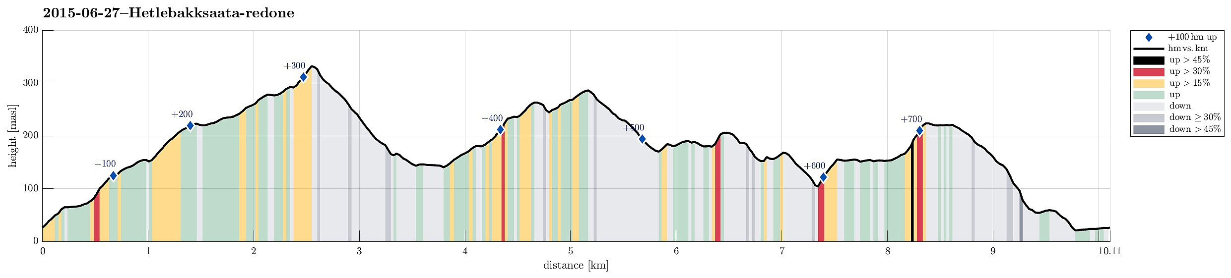 I parked in Breistein, near the place, where the ferry leaves to Osterøy. Right from there, I found a simple path through the forest up to a paved forest path, which lead me first in northwestern direction. After a turn to the left, I found the path towards Hetlebakksåta -- easily visible -- leaving to the left. I followed this (nice!) path upwards, first via Nuken, then Fjellbruna, towards Fjellsteinen, where a beautiful small lake is formed by a dam. Easily and quickly, I continued upwards to Hetlebakksåta, from where I enjoyed nice views in all directions (mostly towards south, west, and north, though). From there, I descended, first in southern direction, then turning right and continuing in northwestern direction, towards Hetlebakka. I followed a narrow street to the other side, >>>
Hetta from Fyre
- Date:
- 21.06.2015
- Characteristic:
- Hillwalk
- Duration:
- 4:00h
- Distance:
- 8.3km
 We left our car at the E16, right next to the bridge, which leads to Fyre. There is also a pointer towards Grindaflethytta (along a marked hiking path). Around Fyre, we first walked on a farming road, before we followed the sign that lead us to the left and up (primarily following the main path towards Grindflethytta). After a short distance, the path turns left, before it then, at about 400masl, turns right again. Exactly in this other turn, we continued northwards on what previously was a forest road (we basically walked the whole forest road in between numerous young and small trees that had started to grow on this road -- seemingly not used to often! :-)). We followed this road until it ends right next to a stream that comes down Trolladalen, separating Stalheimsnipa (on the other, >>>
Bont from Jordalen
- Date:
- 20.06.2015
- Characteristic:
- Hillwalk
- Duration:
- 2:00h
- Distance:
- 3.4km
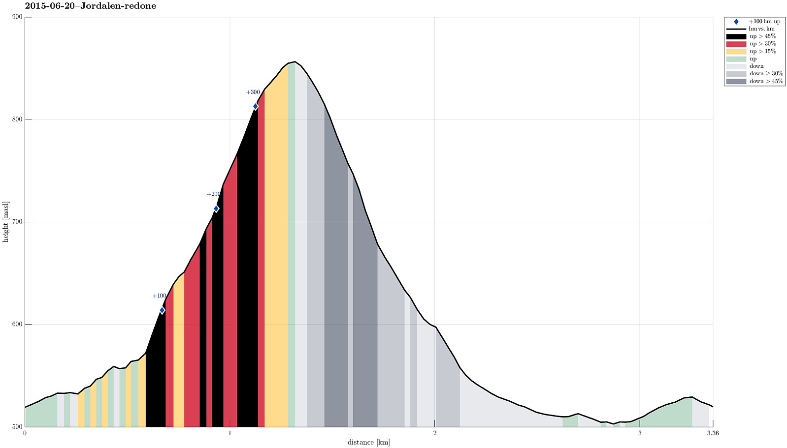 Leaving Nærøydalen (just underneath Stalheim) to the north, we entered Jordalen through the steep, narrow and slippery tunnels that lead from about 130m above sealevel (in Nærøydalen) up to Jordalen (on about 420masl) -- quite impressive to start with! :-)
We then drove up to the first farm on the eastern side of the valley (at about 520masl).
From there, we first followed a forest path, leading gently upwards in a northeastern direction. We crossed a fence and then ascended (more or less following the steepest possible path) towards the east, later more towards SE. We passed a place that is called Bont (almost flat), before we continued towards Fossaholena. All in all, we did not get up to significant heights -- instead, we met an increasing amount of snow and since we did not have >>>
Leaving Nærøydalen (just underneath Stalheim) to the north, we entered Jordalen through the steep, narrow and slippery tunnels that lead from about 130m above sealevel (in Nærøydalen) up to Jordalen (on about 420masl) -- quite impressive to start with! :-)
We then drove up to the first farm on the eastern side of the valley (at about 520masl).
From there, we first followed a forest path, leading gently upwards in a northeastern direction. We crossed a fence and then ascended (more or less following the steepest possible path) towards the east, later more towards SE. We passed a place that is called Bont (almost flat), before we continued towards Fossaholena. All in all, we did not get up to significant heights -- instead, we met an increasing amount of snow and since we did not have >>>
Storrinden
- Date:
- 19.06.2015
- Characteristic:
- Hillwalk
- Duration:
- 0:45h
- Distance:
- 3.1km
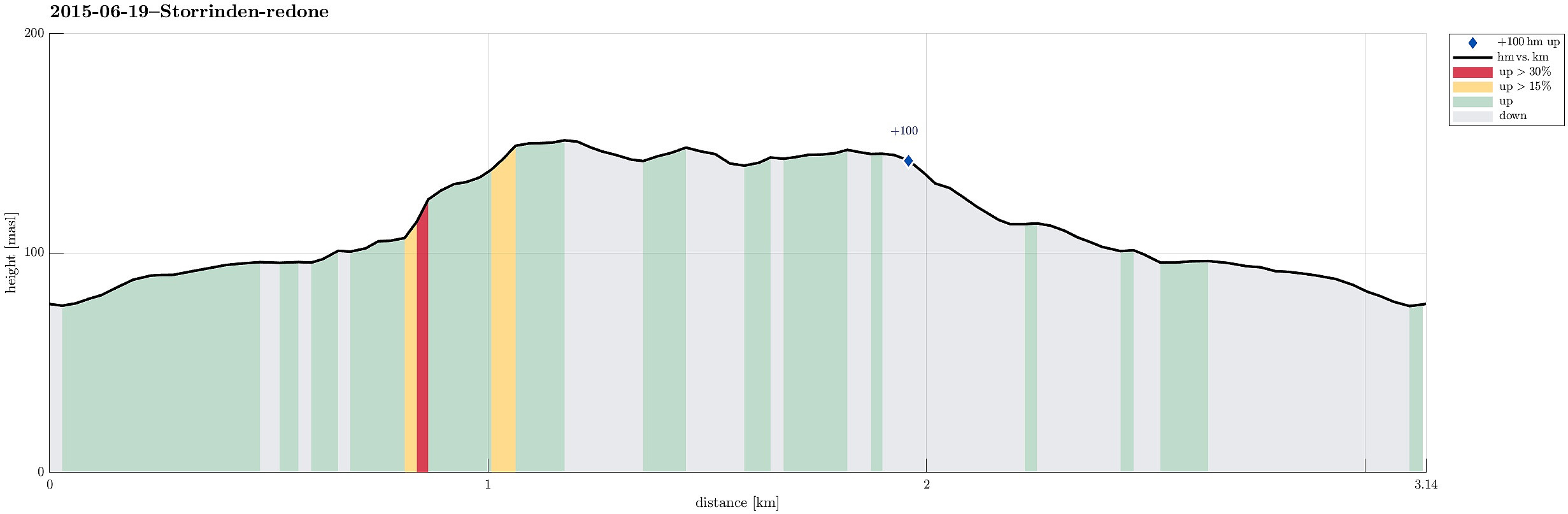 Leaving Kokstadvegen to Storrinden, a parking place was found after about 100m. From there, it's just following a gravel road up to the "top" (at times, one can follow a trail, which is easy to find and follow). On the top, one sees (a bit) towards the east and north (even though the trees are too high to really have a good view). On the other side, one can look down onto Flesland airport, which is a worthwhile experience! :-) All in all, this really is an easy and quick tour (45mins., or so).
Herlandsfjellet via Skåldalsnipa and Skåldalsfjellet
- Date:
- 14.06.2015
- Characteristic:
- Hillwalk
- Duration:
- 3:00h
- Distance:
- 9.7km
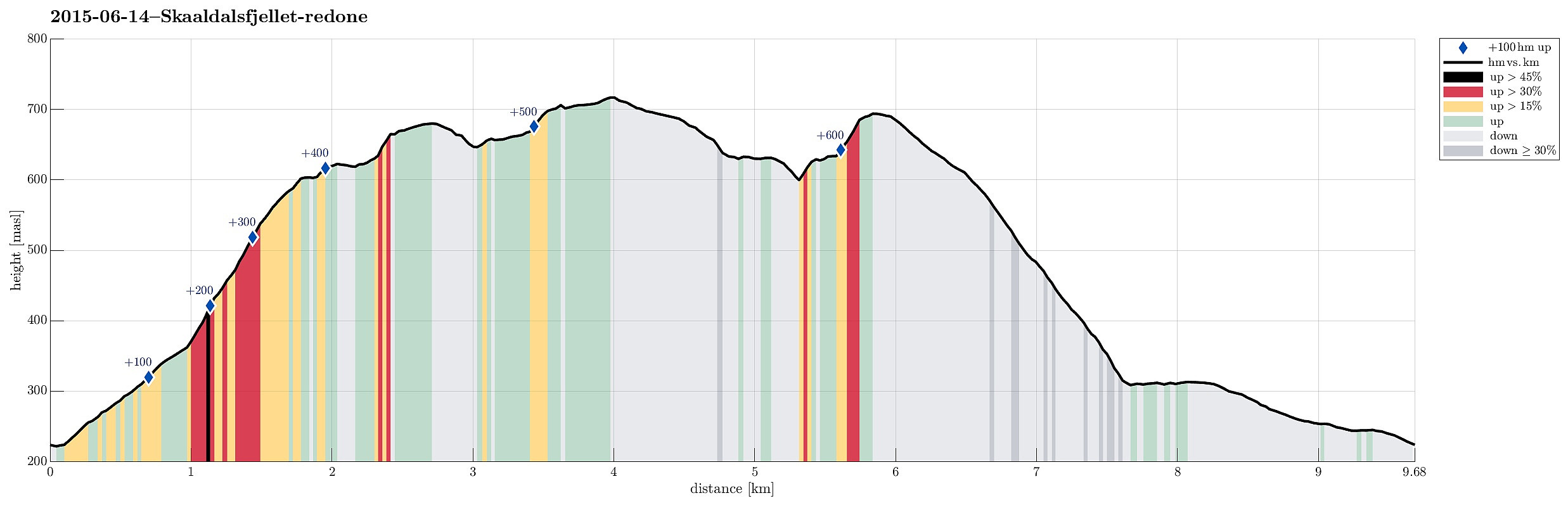 Driving up Gullfjellsvegen, which leads to the parking place right next to Osavatnet, we parked already early, where a small street leaves to the left, up Skålsdalen. We first followed this small street, which steeply winds towards a few houses. Before the very end of the asphalt road, we left towards the left, first along a simple tracktor track, then across the steep medow up towards the ridge, which then leads up to Skåldalsnipa. On the ridge, we connected to a simple path, which nicely lead us up to Skåldalsnipa -- the last meters underneath a material lift, which extends there from Skålsdalen. From Skåldalsnipa, we continued via the heights, mostly in a northeasterly direction and quite a bit into the direction of Arna / Reppadalen. Then we crossed Larsmyren -- quite wet indeed! >>>
Ørnafjellet
- Date:
- 07.06.2015
- Characteristic:
- Hillwalk
- Duration:
- 1:06h
- Distance:
- 4.6km
 Starting from NUTEC, we first connected (via some stairs in the back of Hesteviken and through the forest along a simple path) to the path (called Mørderbakken!), which leads up to Ørnafjellet from the east (quite steep, but not as bad as the name would suggest). Once on the ridge, we turned left to quickly ascend to Ørnafjellet, where we turned. Back, we took the path that connects to the road, which we then descended back to NUTEC.
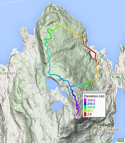
Web page WestCoastPeaks.com provides useful information about Lyderhorn and Ørnafjellet .
Web page SpillBy.com describes Ørnafjellet and
web page FotTurer.com describes a tour up Ørnafjellet .
Starting from NUTEC, we first connected (via some stairs in the back of Hesteviken and through the forest along a simple path) to the path (called Mørderbakken!), which leads up to Ørnafjellet from the east (quite steep, but not as bad as the name would suggest). Once on the ridge, we turned left to quickly ascend to Ørnafjellet, where we turned. Back, we took the path that connects to the road, which we then descended back to NUTEC.
Web page WestCoastPeaks.com provides useful information about Lyderhorn and Ørnafjellet .
Web page SpillBy.com describes Ørnafjellet and
web page FotTurer.com describes a tour up Ørnafjellet .
