Archive - Date
Archive - Activity
-
Climbing (43)
- Alpine climbing (31)
- Ice climbing (3)
- Mixed climbing (1)
- Sport climbing (3)
- Via ferrata (1)
-
Other trip (5)
- Expedition (5)
-
Other winter trip (5)
- Snowshoe trip (5)
-
Ski trip (449)
- Backcountry skiing (4)
- Cross-country skiing (2)
- Randonnée/Telemark (441)
-
Trip by foot (507)
- Alpine trip (47)
- Hike (196)
- Hillwalk (205)
- Jogging (4)
- Walk (55)
Peakbook-Friends


Mont Buet
- Date:
- 10.07.2009
- Characteristic:
- Hike
 Thursday, 9th July 2009
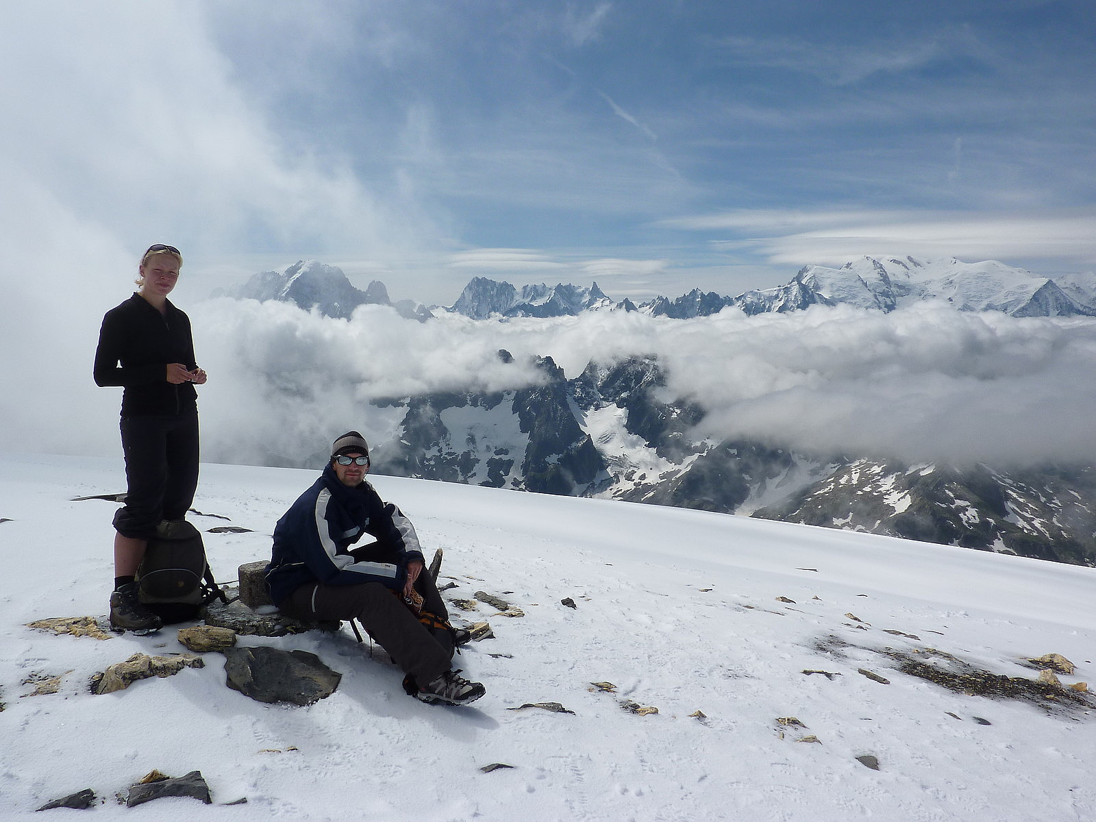
It was a beautiful morning to wake up to. Blue skies, minimal cloud on the mountain tops and fresh air. Hanna and I had the room with the view too, which meant we could step out onto the balcony and look straight up to the Aiguille du Midi – what more could you ask for? We met up with Dan and Tobbe at 8.30am for breakfast, so there was plenty of time for us both to shower before that. Unfortunately the 7.50 Euros breakfast proved a little disappointing. Apart from the fresh bread, croissants and coffee, there wasn’t much else on offer to satisfy our hungry hiker’s stomachs! Nevertheless, after we’d finished up in the dining room, we left a bit of kit behind in the hotel and set off for the train station, via the supermarket, to stock up on some food for lunch >>>
Thursday, 9th July 2009
It was a beautiful morning to wake up to. Blue skies, minimal cloud on the mountain tops and fresh air. Hanna and I had the room with the view too, which meant we could step out onto the balcony and look straight up to the Aiguille du Midi – what more could you ask for? We met up with Dan and Tobbe at 8.30am for breakfast, so there was plenty of time for us both to shower before that. Unfortunately the 7.50 Euros breakfast proved a little disappointing. Apart from the fresh bread, croissants and coffee, there wasn’t much else on offer to satisfy our hungry hiker’s stomachs! Nevertheless, after we’d finished up in the dining room, we left a bit of kit behind in the hotel and set off for the train station, via the supermarket, to stock up on some food for lunch >>>
Langdale Pikes to Grasmere
- Date:
- 25.05.2009
A very steady and pleasant ascent of High Raise, apparently the most scenic viewpoint in the whole of Lakeland. The route took me up in warm sunshine from Landale youth hostel over the undulating plateau of Dow Bank-Lang How-Castle How up towards Sergeant Man, a nice little top shortly before the rather more dull shoulder that leads onto High Raise. Its not an interesting mountain itself to climb, but you do indeed get very good views all around; west towards Great Gable and Scafell and more closeby the drop down into the Langstrath valley, then north to Keswick, Skiddaw and Blencathra and the Drewent fells ot to the northwest. And east gets you the views of the Helvellyn ridge stretched out from Clough Head all the way down towards Fairfield and Rydal Fell near Ambleside. Great stuff. From >>>
Wastwater to Langdale
- Date:
- 24.05.2009
I love this route to bits! Despite having had a rather miserable hike the previous day, this one was amazing. Great weather, and great views and greater company - which was more of an unintentional thing. Started off from the Wastwater YHA, made my way back up the tedious tarmac road to the northern end of Wastwater, and from there began the steady but popular route of ascent up Scafell Pike which runs along Lingmell Gill. Its pretty OK, nothing amazing though and it starts to flatten out after Hollow Stones. From there though its a somewhat loose climb up a gully to reach the col bewteen Scafell and Scafell Pike, but you're virtually at the top by the tim you get here. A nice gently slope up to the summit and here I was joined, as I expected by a lot of other hikers. All of us were happy faced >>>
Ennerdale to Wasdale
- Date:
- 23.05.2009
There's not a lot to say about the weather on this day except that it started off in heavy rain with an unpleasant hike up rain-soaked grass to Steeple, where I got a bit lost so I have no idea how I got to Pillar. Somehow I had some luck in passing some other hikers who pointed me in the direction of Pillar so I followed their vague directions and found myself reassuringly up on its summit in yet more rain and with absolutely no views to speak of whatsoever. Nevertheless I carried on in the direction of the descent I thought I should be taking. Turns out it took me down the wrong side of the fell and back on to the Ennerdale side of Pillar, but at least when I got to this point it had stopped raining, the cloud had lifted and I could actually figure out where I was and where I needed to get >>>
Buttermere to Ennerdale
- Date:
- 22.05.2009
The weather on this day was a bit overcast, so it wasn't the most amazing day ever. Nevertheless, I did the usual hike up through the forest to get above Buttermere and onto the ridge to the top of Red Pike. Continued along the obvious line passing over the rock-strewn tops of High Crag and High Stile, then descended the somewhat steep and stony path to Scarth Gap before getting up onto Haystacks. Went as far as Blackbeck tarn and then descended in a southwest direction along a stream into Ennerdale, coming out quite close to Black Sail youth hostel. Very long and boring walk along Ennerdle in the rain to get t the youth hostel. The only consolation was that I had a whole 6-bed dormitory to myself :-) And had a good nights sleep.
Patterdale to Windermere
- Date:
- 18.04.2009
- Duration:
- 5:00h
A really splendid day in perfect weather - started off early-ish from Patterdale youth hostel, walking along the road past Brotherswater to Hartsop. It was bang in the middle of the lambing season too so I got to see some cute little lambs and their mums along the way :-) From Hartsop it was a plod up the track toward Hayeswater, from where I then ascended up to The Knott. Great views across the Brotherswater valley to the central fells of Fairfield, Dove Crag and Middle Fell etc. Continued along at a speedy pace along the nice high ridge toward High Street. Took a short break as I reached Thornthwaite Crag and then cracked on towards Froswick, Ill Bell and Yoke. I was making such good time I was practically down in Troutbeck by lunchtime, having caught the sun a little on my arms. It had been >>>
Grasmere to Patterdale
- Date:
- 17.04.2009
A nice spring's day which started off sunny from Grasmere, with the view to ascending over Great Rigg, Fairfield and St. Sunday Crag on my way to Patterdale. Unfortunately this didn't quite work out so well because it got so windy after getting out onto Great Rigg that I decided not to go further and headed back down toward Grasmere. After getting back down to the road, I re-planned my day and decided to head up towards Grisedale Tarn via Tongue Gill. Either way I had to get to the Patterdale youth hostel where I was booked to stay overnight, so this was my alternative and more low level route. Quite fortunately, even though it had clouded over a bit by the time I reached the tarn, the wind had died down quite massively since the morning, and I ended up continuing back up and over St. Sunday >>>
Skiddaw - winter
- Date:
- 24.01.2009
A walk up to the summit of Skiddaw from Bassenthwaite with Syam, Dave and Bev Smith. The route went up from the north side over Long Side edge, the weather was pretty unpleasant for most of the day and the wind was very strong after we had passed Carl Side and started the final pull up onto Skiddaw. I didn't have crampons with me and had a couple of awkward and delicate steps on the icy rocks. Trouble was that there wasn't a lot of snow cover, so what was there was quite hard and frozen. We descended soon after passing the summit trig point and down the northeastern side down to Whitewater dash. Had some lunch here before the rain got heavier and then continued on our way down to Bassenthwaite again following the Cumbria Way. Coffee with Syam, Bev and Dave again in Keswick before I got on a >>>
Island Peak
- Date:
- 19.11.2008
- Characteristic:
- Hike
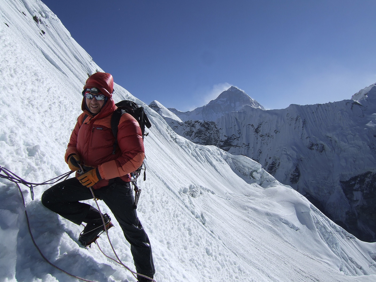 After the exceptionally fantastic ascent of Lobuche East on my birthday, we had just one more peak to complete the 4-week trip around the Khumbu region of Nepal: Island Peak.
Wednesday, 19th November 2008: Chukung to Island Peak BC
After sleeping like a log for a decent 10 (or maybe even 11) hours, we began our journey to Island Peak Base Camp from the tea house in Chukhung under increasingly overcast skies, so it didn’t feel as warm as the previous day. It was a short 3-hour walk, which was immensely busy with climbing groups in comparison to the BC for Lobuche East . Once we arrived there was a luxurious mess tent waiting for us to dive into for hot drinks and lunch! It was kitted out with big, roomy chairs and a table laden with a huge selection of instant hot drinks :-) Amongst the selection of hot drinks were >>>
After the exceptionally fantastic ascent of Lobuche East on my birthday, we had just one more peak to complete the 4-week trip around the Khumbu region of Nepal: Island Peak.
Wednesday, 19th November 2008: Chukung to Island Peak BC
After sleeping like a log for a decent 10 (or maybe even 11) hours, we began our journey to Island Peak Base Camp from the tea house in Chukhung under increasingly overcast skies, so it didn’t feel as warm as the previous day. It was a short 3-hour walk, which was immensely busy with climbing groups in comparison to the BC for Lobuche East . Once we arrived there was a luxurious mess tent waiting for us to dive into for hot drinks and lunch! It was kitted out with big, roomy chairs and a table laden with a huge selection of instant hot drinks :-) Amongst the selection of hot drinks were >>>
Lobuche East
- Date:
- 17.11.2008
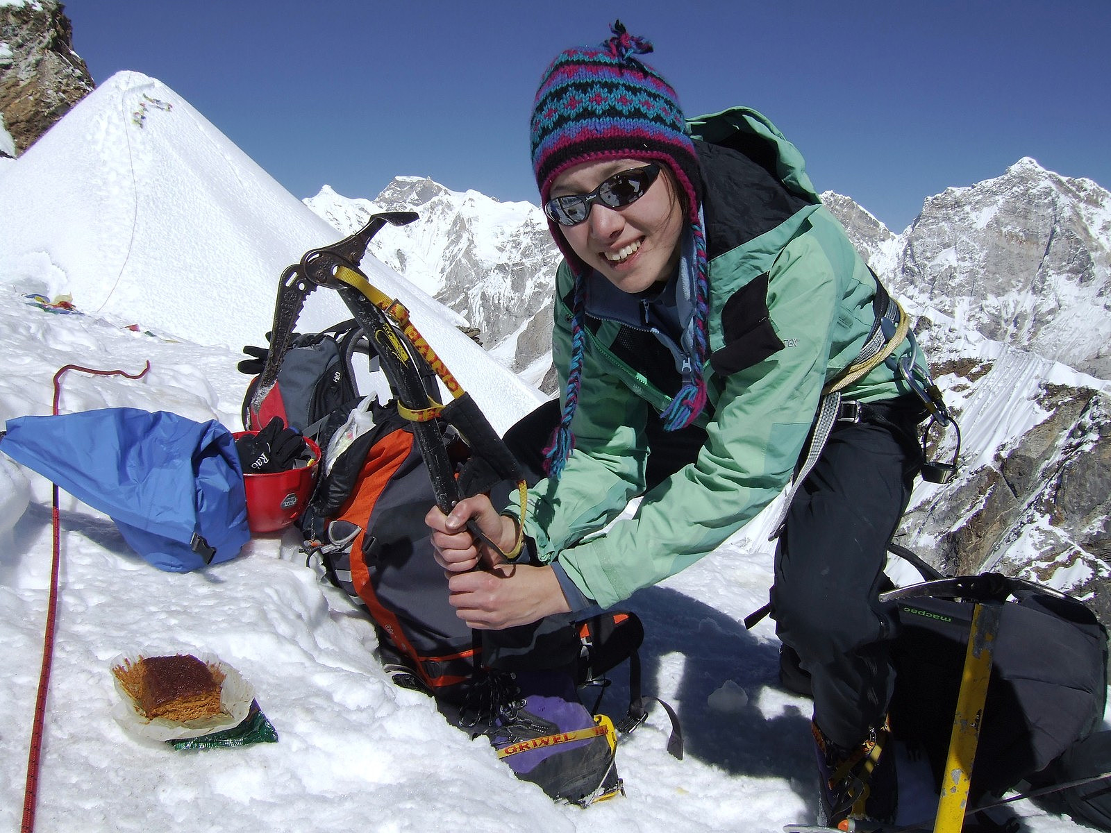 Lobuche East was a memorable summit of a 4-week trip in Nepal. I joined a trip organised by a UK-based company (Adventure Peaks), it involved a lots of ups and downs (both physical and in the psychological sense!), much laughing and of course, spectacular views. But for me Lobuche East was the highlight of the trip because the ascent coincided with my 25th birthday .-)
Sunday, 16th November 2008
Our approach walk to Lobuche East base camp was from Lobuche village, which was on the other side of the mountain. We had spent 2 days at Lobuche village after walking from Dzonghla, which was where we had stayed after our descent from the Cho La Pass. So to get back to the base camp, we were effectively retracing our steps from 2 days earlier, but not going as far back as Dzonghla. The base camp was >>>
Lobuche East was a memorable summit of a 4-week trip in Nepal. I joined a trip organised by a UK-based company (Adventure Peaks), it involved a lots of ups and downs (both physical and in the psychological sense!), much laughing and of course, spectacular views. But for me Lobuche East was the highlight of the trip because the ascent coincided with my 25th birthday .-)
Sunday, 16th November 2008
Our approach walk to Lobuche East base camp was from Lobuche village, which was on the other side of the mountain. We had spent 2 days at Lobuche village after walking from Dzonghla, which was where we had stayed after our descent from the Cho La Pass. So to get back to the base camp, we were effectively retracing our steps from 2 days earlier, but not going as far back as Dzonghla. The base camp was >>>

