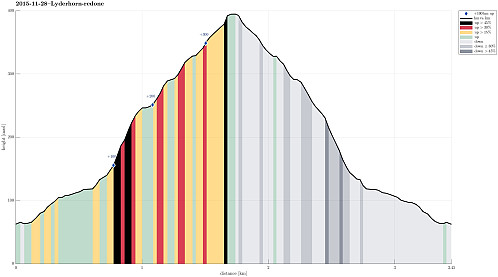
Lyderhorn (28.11.2015)

Written by HHauser (Helwig Hauser)

| Start point | Kjøkkelvik school (60m) |
|---|---|
| Endpoint | Kjøkkelvik school (60m) |
| Characteristic | Hillwalk |
| Duration | 1h 15min |
| Distance | 3.5km |
| Vertical meters | 354m |
| GPS |
|
| Ascents | Lyderhorn (396m) | 28.11.2015 |
|---|---|---|
| Visits of other PBEs | Lyderhornhytten (lokalitet) (396m) | 28.11.2015 |

Trip Summary
We parked near Kjøkkelvik school and started our ascent of Lyderhorn via Lyderhornslien. While the main path up Lyderhorn (from there) departs from the road already in one of the lower turns, we aimed for a less used, small path that departs from Lyderhornslien at this road's very end---right next to the building blocks on top (pass by the larger building blocks, heading north, for a few meters until you see wooden stairs leading up right behind one of the blocks). From there, it's straight-forward to follow the path upwards. Before getting to the top of Lyderhorn, one meets a more frequented path that leads to the top from the northern side. In half an hour, we reached the top and enjoyed some strong November weather impressions there. We basically returned on the same path down, avoiding the more popular path southwards from the top, assuming that it would be slippery. All in all, a quick and nice hike into some refreshing November air. :-)
Photos
Selected photos are available as Google+ photo album.
Useful Resources
Web page WestCoastPeaks.com provides useful information about Lyderhorn and Ørnafjellet
and also Petter Bjørstad has a page about Lyderhorn.
On Bergentopp 200 there is a page (in Norwegian) about Lyderhorn.


User comments