Kossdalen (02.01.2016)

| Startsted | Hosanger (15moh) |
|---|---|
| Sluttsted | Hosanger (15moh) |
| Turtype | Spasertur |
| Turlengde | 2t 30min |
| Distanse | 7,7km |
| Høydemeter | 447m |
| GPS |
|
| Andre besøkte PBE'er | Kossdalssvingane (125moh) | 02.01.2016 |
|---|---|---|
| Mjøs Metallvarefabrikk p-plass (12moh) | 02.01.2016 |

Trip Summary
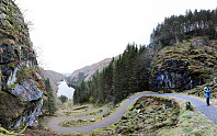
We drove to Osterøy and then on Osterøy first to Lonevåg. From there, we continued to Hosanger at Osterfjorden, on the northwestern side of Osterøy. In Hosanger, we took a sharp turn to the right, where a sign leads to the Waldorf school in Holanger. Before getting to the school, we parked right next to the graveyard. From there we walked along a simple road, first on the western side of the little stream that comes down from Holevatnet, that leads directly into Kossdalen. In Kossdalen, the path switches sides and continues further in on the eastern side of the valley, passing by Kossdalsvatnet. At the very end of Kossdalen, one finds a place called Gråura, where certainly some have enjoyed camping already---it's just a very nice place! :-) Behind Gråura, Kossdalssvingane start---an impressive path, very steep, that leads up to Svenheim in about ten narrow S-curves. Up there, we enjoyed the look to the other side, before returning (mostly the same path back). Before getting to Holevatnet, however, we turned right and followed another forrest road, passing by Holevatnet on the other (eastern) side. This path lead us to the road that passes by the school and back down to the graveyard. All in all, Kossdalssvingane really are a very impressive construction from more than 100 years ago with a number of sweet spots for great views! :-)
Photos
Selected photos are available as Google+ photo album.


Kommentarer