Arkiv - dato
Arkiv - aktivitet
-
Annen tur (1)
- Kajakkpadling (1)
-
Annen vintertur (4)
- Trugetur (4)
- Fottur (703)
-
Skitur (3)
- Fjellskitur (3)
-
Sykkeltur (110)
- Blandet sykling (35)
- Gatesykling (5)
Arkiv - Etter geografi
"Peakbookvenner"
Lister jeg samler etter
Nonhøyen etc.
- Dato:
- 23.08.2025
- Turtype:
- Blandet sykling
- Turlengde:
- 10:00t
- Distanse:
- 94,7km
 It looked like a promising Saturday and I wished to do another bike-hiking excursion to see a few places that I had not seen so far. I started by cycling via Straume to Søreide and then further into the direction of Lagunen. After cycling around Apeltunvatnet in its south, I connected to Tranevatnet and from there, after passing under E39, along Birkelandsvatnet to Dyngelandsvegen. This road brought me then to Helldal, where I eventually joined Hardangervegen to pass by Grimevatnet and then Søylevatnet. Cycling along this rather much used (and rather narrow) road is not exactly fun for the cyclist and one should only do it, when prepared for a bit of stress. Leaving Hardangervegen, I then continued along Unnelandsvegen, south of Haukelandsvatnet. At Storeklubben, I made my first short >>>
Mixed excursion to Frotveit
- Dato:
- 31.05.2025
- Turtype:
- Blandet sykling
- Turlengde:
- 5:00t
- Distanse:
- 61,0km
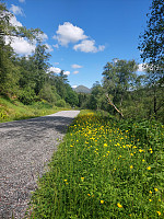 Given the nice Saturday, it was just to get some fresh air! I took my bike and started in southern direction. After passing Steinsvik, I then connected to Lagunen. My attempt to continue further towards Nesttun from there, was inhibited by some road work, making me cycle around Apeltunvatnet, instead. From Nesttun, I then connected to Øvsttun, where I explored the highest point. Thereafter, my goal was to bike up to Totland to do some more exploration. I left my bike at the parking lot at the end of Totlandsvegen and ascended to the hill in the west of it. Once up there, I decided that I could simply traverse the heights in order to get via Kollifjellet tp Ytstafjellet. After doing that, I returned via the forest road that apparently is used as a skiing track in winter. Once down to >>>
Vallaheiane via Larsaberget from Tranevatnet
- Dato:
- 11.05.2025
- Turtype:
- Blandet sykling
- Turlengde:
- 4:30t
- Distanse:
- 40,2km
 The main idea was to get some fresh air. I thus took the bike and started with the idea to explore Vallaheiane from Tranevatnet. I first biked south and crossed the partially closed off bridge at Straume. I then continued towards Steinsvik, where I left the "main road" to take a look at Ospåsen, a bit further south. The matter of fact that there's also a golf course in this area does not make getting around easier. Back on my bike, I continued, crossing over Flyplassvegen, to the sports arena next to Grimseidvegen. After a short bio-break at Lagunen, I continued around Apeltunvatnet, then to Iglavatnet, and further to Tranevatnet. I then parked my bike along the gravel road on the south side of Tranevatnet to start my exploration on foot from there. I first found a good way >>>
Nubbevatnet (twice) via Nattlandsfjellet
- Dato:
- 12.04.2025
- Turtype:
- Blandet sykling
- Turlengde:
- 4:30t
- Distanse:
- 31,3km
 We had agreed to make a short hike together, from Nattlandsfjellet to Nubbevatnet. To get there, we took our bikes, first along Nordåsvatnet, then via Paradis up to Nattlandsfjellet. From the parking strip south of Sveane, we then hiked up (via Sveane) and over the long ridge into the direction of Orrehaugane, before then crossing over to Nubbevatnet. At Baunehytten, on the north end of Nubbevatnet, we then enjoyed a nice little break. After enjoying the sun a little, we then walked back towards Ramsdalen and Nattlandsfjellet, following the main route (gravel road southwards, also connecting to Helgeseter). Once back at the parking at Nordre Nattlandsfjellet, we learned that the keys to unlock two of our bike locks weren't with us as expected. After a bit of searching, we thought that >>>
Lauvåsen in Jordalen
- Dato:
- 19.01.2025
- Turtype:
- Blandet sykling
- Turlengde:
- 5:00t
- Distanse:
- 54,0km
 We had discussed a possible hike up to Storsåta, northeast of Jordalen. The first qualification that happened was our decision to approach Jordalen with our bikes. All this worked nicely and smoothely, using the bike-tunnel between Fyllingsdalen and Minde. The next qualification then was to cross over to Munkebotn via Fløyfjellet. After checking out two options to do so that did not work out (at Lappen and Knatten we read that cycling is not allowed on Søre Kamvei!), we took a route up from Skansemyren. Passing by Skomakerdiket, we then quickly crossed over Fløyfjellet before making it further to Storevatnet and then further down to Munkebotn (the descent from Fløyfjellet down to Munkebotn is quite steep, though). At Munkebotsvatnet, we made a short break to enjoy our packed lunch. >>>
Storhelleren/Bjørndalshelleren
- Dato:
- 18.01.2025
- Turtype:
- Blandet sykling
- Turlengde:
- 2:30t
- Distanse:
- 17,1km
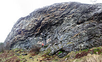 Given a rather wet winter day, we decided to explore a place, which we had on our radar for a while, already: Storhelleren/Bjørndalshelleren near Loddefjord. To add a bit to this plan, we decided to combine this excursion with a bike-trip there and back. After first cycling north on Bjørgeveien into the direction of Loddefjord, we chose to cross the bridge at Hetlevikstraumen and continue to Loddefjord on the west-side of Bjørndalspollen. At Loddefjord, we once again ended up in this dead-end loop for pedestrians at the north end of Bjørndalspollen (without any reasonable option to cross the road over to Loddefjord -- what a city planning mistake?!!). After quickly looping back, we made it onto the road and thus further northwards to the access road for the transformer at Grøvledalen. >>>
Storenuvarden and more
- Dato:
- 19.10.2024
- Turtype:
- Blandet sykling
- Turlengde:
- 6:30t
- Distanse:
- 70,6km
 Given the nice autumn weather, I made a plan to cycle around Vidden and explore some minor hills along the way. I started by cycling around Nordåsvatnet (in its north), continuing to Paradis. From there, I took the road through Sanddalen to get to the main axis towards Arna from Nesttun. It started in Sanddalen that I understood that this trip will be special, given a chain that had become quite slippery, already -- the relatively steep part upwards on Sandbrekkevegen I already had to push the bike... My first exploration goal of the day was to bike out Hardangervegen right next to the train tracks on the other, southeastern side of Midtunelva. This works, but the path (or better "path") is not really prepared and biking there with a street bike, for example, is not reasonable. >>>
Bike-hiking hills near Drotningsvik
- Dato:
- 06.10.2024
- Turtype:
- Blandet sykling
- Turlengde:
- 4:00t
- Distanse:
- 32,9km
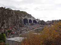 Given the medium-nice weather -- certainly good enough, though! -- I decided to make another bike-hiking trip: this time into the direction of Drotningsvik, where I knew of a couple of hills that I had not visited so far. I started by cycling into the direction of Olsvik, passing by Loddefjord on my way. In the northwest of Harafjellet, I then left my bike behind for the first time, making my way up to Storhaugen. Given the houses that have been built right up to the "top" of Storhaugen, one does not really get any nature feeling up there. The views, however, are quite fine. Next, I aimed at Godvikaskjenet, approaching it from the northeast. Godvikveien leads up there quite steeply and I left my bike behind "half way up" that road. Once closer to the "top", >>>
Bulandet by bike (and Høgkletten)
- Dato:
- 08.09.2024
- Turtype:
- Blandet sykling
- Turlengde:
- 5:00t
- Distanse:
- 31,5km
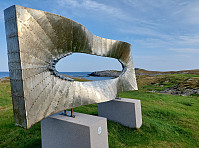 We got onto our bikes on Værøyna and headed westwards into the direction of Bulandet along Nordsjøvegen. After crossing over several bridges, we made our first stop on Gjørøyna to take a look at "Ro" by artist Geir Hjetland. From there, we continued further southwestwards until we "hit" the end of the road at Halsøy. There, we stepped up to Slotteholmen to enjoy some views. We then biked over to Nikkjøyna and from there further to Hellersøyna, where we walked a little bit southwards to see the sculpture of Berte and Hansine. Then, we biked back to Værøyna (along the same road that we had taken to Bulandet, i.e., Nordsjøvegen). At Værøyna, we had a brief discussion and decided that only one of us would also include the short hike up to Høgkletten. I thus >>>
Bike-hiking Landåsfjellet and more
- Dato:
- 01.09.2024
- Turtype:
- Blandet sykling
- Turlengde:
- 4:00t
- Distanse:
- 37,5km
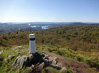 Somehow, I thought that this Sunday was the day for visiting Nattlandsfjellet and checking out the view-point right above the tunnel of Nye Sædalsveien. I got onto my eBike and biked around the south of Bønes, following the north shore of Nordåsvatnet. This brought me to Gamlehaugen, where I decided to interrupt my bike-trip for a short exploration of the area around the King's house. My first goal there was to get up to the small hill in the southeast of the mansion. I first thought that there would be a way to get there "directly", just to find that this little hill has some rather steep cliff on its west-side -- not high, but high enough to be an obstacle. Walking around, however, brought me to a path that -- while apparently not much used -- lead me easily and conveniently >>>


