Arkiv - dato
Arkiv - aktivitet
-
Annen tur (1)
- Kajakkpadling (1)
-
Annen vintertur (4)
- Trugetur (4)
- Fottur (703)
-
Skitur (3)
- Fjellskitur (3)
-
Sykkeltur (110)
- Blandet sykling (35)
- Gatesykling (5)
Arkiv - Etter geografi
"Peakbookvenner"


Lister jeg samler etter
-
Bergen ≥ 50m pf. og ≥ 100 m.o.h.
(87/89)
 97%
97% -
Most dominating tops of the Bergen peninsula
(68/75)
90%
-
Utvalgte topper og turmål i Bergen
(299/339)
88%
-
Alle topper i Bergen
(344/392)
87%
-
Opptur Bergen
(99/113)
87%
-
De syv fjell rundt Bergen
(6/7)
85%
-
Sund ≥ 50m pf.
(14/18)
77%
-
Os ≥ 50m pf.
(25/34)
73%
-
Søyler (fastmerker) i Bergen
(66/100)
66%
-
Fjell ≥ 50m pf.
(21/32)
65%

Lundåsane from Hausdalen
- Dato:
- 14.09.2025
- Turtype:
- Fottur
- Turlengde:
- 3:00t
- Distanse:
- 5,9km
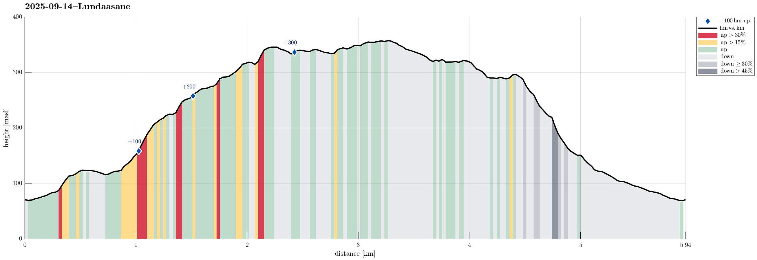 We wished to explore the Hausdalen-side of Lundåsane and thus drove to Hausdalen, where we parked a bit south of Håland. From there, we first walked up a gravel road that extends parallel to Hålandsbekken. About half way up, I decided that I wished to explore Storerinden, in the east of Slokadalen, also. Stepping up to this hill was straight-forward, while not on a trail, though. From Storerinden, while not really a prominent "peak", I still got a nice view towards Hausdalshorgi (it's always nice to see Hausdalshorgi!). I then continued across the ridge to re-connect with the gravel road near the T-junction, where one leg of the gravel road extends a bit further up to Plasset. Instead of following the gravel road any further, though, I used a trail (maybe more a former trail) >>>
Lysehornet from Kismulvegen
- Dato:
- 07.09.2025
- Turtype:
- Fjelltur
- Turlengde:
- 4:00t
- Distanse:
- 6,9km
 We had the idea to hike Lysehornet from the northeast (from Kismulvegen) and thus drove via Fana to Kalandsvatnet. Near house #47 along Kismulvegen, we parked -- not without an interaction with a man, who made it explicit that he'd wish us to park in Bygarasjen instead. We then started our hike into southwestern direction, first following a side-part of Kismulvegen up and towards Lindedalen. At large, the plan was to get to Lysehornet without a trail, while then taking a trail back down. After passing the upper houses (and quite a bit of rusting garbage of small to large sizes), we eventually made into the forest of Lindedalen. The first high point to reach was Hovåsen and the ascent from the northeast was a bit steep (but well doable). From Hovåsen, the plan was to hike around the >>>
Golta in mixed weather
- Dato:
- 31.08.2025
- Turtype:
- Spasertur
- Turlengde:
- 2:00t
- Distanse:
- 5,0km
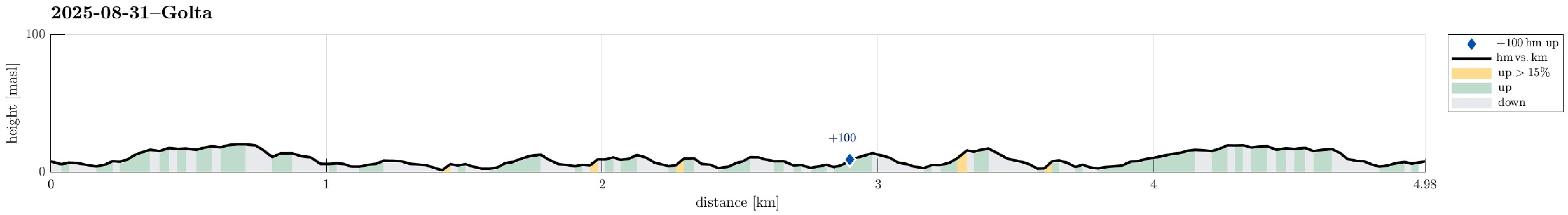 With a rather mixed weather forecast, we wished to make a brief excursion to the Atlantic and chose Golta as our goal. After driving there from Bergen and parking at Goltavegen, right between Vogga in the west and Goltosen in the east, we walked towards the coast from there, first following the marked trail. To get around Lutavika, we then followed the coast in norther direction, crossing over to the northwestern part of Golta at the southern end of Jonsvikadalen. On the other side, we then first visited a nice vista point south of Luten, before walking further to Sandvika. There, we basically turned around, then following the marked trail all the way back to the parking place. Given that the day was overall rainy, we actually had quite OK weather and enjoyed this short walk very much! >>>
Turku Saturday morning walk
- Dato:
- 30.08.2025
- Turtype:
- Spasertur
- Turlengde:
- 4:00t
- Distanse:
- 15,9km
 I had a few morning hours on this Saturday before heading back to Bergen, which I wished to use for a walk to see a bit of Turku. I started by crossing the Aura river at Kirjastosilta, heading to the Samppalinnanvuori vantage point for a first view across the city. From there, my next goal was the hill-top Luolavuori, hoping for some additional views from up there. While stepping up there, I also looked at the enormous water tower not far from the hill-top. On my way down from Luolavuori, I then passed by an impressive boulder, right north of the water tower, that apparently a glacier left there a long time ago. My next goal was then to cross the Aura river using the small ferry Föri, but when I got there, I learned that it was not operated, unfortunately. I thus decided to walk around >>>
Nonhøyen etc.
- Dato:
- 23.08.2025
- Turtype:
- Blandet sykling
- Turlengde:
- 10:00t
- Distanse:
- 94,7km
 It looked like a promising Saturday and I wished to do another bike-hiking excursion to see a few places that I had not seen so far. I started by cycling via Straume to Søreide and then further into the direction of Lagunen. After cycling around Apeltunvatnet in its south, I connected to Tranevatnet and from there, after passing under E39, along Birkelandsvatnet to Dyngelandsvegen. This road brought me then to Helldal, where I eventually joined Hardangervegen to pass by Grimevatnet and then Søylevatnet. Cycling along this rather much used (and rather narrow) road is not exactly fun for the cyclist and one should only do it, when prepared for a bit of stress. Leaving Hardangervegen, I then continued along Unnelandsvegen, south of Haukelandsvatnet. At Storeklubben, I made my first short >>>
Gjønakvitingen from Gjøn (via Selfjellet)
- Dato:
- 17.08.2025
- Turtype:
- Fottur
- Turlengde:
- 8:00t
- Distanse:
- 13,5km
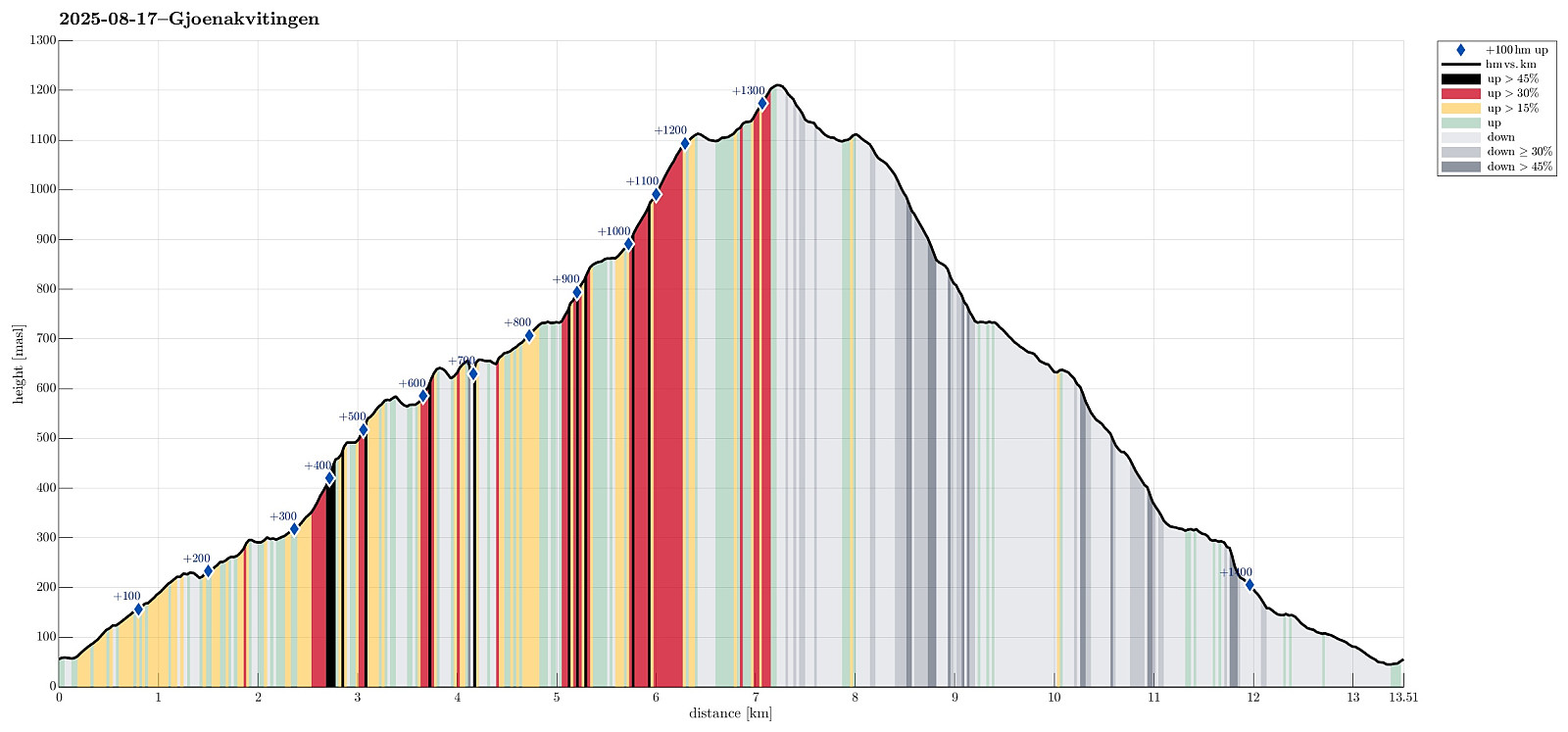 The weather was promising and so we thought this would be a good day to hike up to Gjønakvitingen from Gjøn. From Bergen, we drove towards the East, first along E16, then road #49, before taking road #48 to Eikelandsosen. From there, it was not too far, continuing into eastern direction, before we changed to a narrow road at Holdhus. This way, we drove around the south end of Gjønavatnet in order to get to Gjønavegen, which brought us to Gjøn. At about noon-time, we then started our hike (with enough time on such a nice, long summer Sunday). The one, small "twist", which we had cooked up, when studying the map at home, was to include Selfjellet (via an ascent on the western side of Skarvaelva), before eventually taking the "main trail" down (south of Sauaskorfjellet). >>>
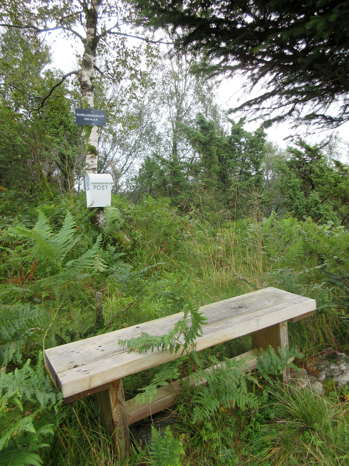
Almelandsfjellet etc.
- Dato:
- 10.08.2025
- Turtype:
- Fjelltur
- Turlengde:
- 3:00t
- Distanse:
- 6,2km
 On this partially wet Sunday, the plan was to make something not too long and not too far away. Since I had not visited Smørkisfjellet before, I "cooked up" a round, starting from Osvegen near Kalandseidet. I somehow thought that I could try an ascent to Blåurskampen from the west (even though I had seen during my map study at home that this side of this hill is very steep with quite some cliffs, actually). I started from right underneath Blåurskampen and already down at Osvegen I wondered whether this really was such a good idea (it was not). I still entered the terrain and quickly found out: (a) it was wet from all the rain, (b) there was a lot of vegetation, and (c) it is truly steep -- at times way too steep there. I still continued (why?), making height meters relatively >>>
Byrkjefjellet, Iendefjellet, and Skeisheia
- Dato:
- 02.08.2025
- Turtype:
- Fottur
- Turlengde:
- 7:00t
- Distanse:
- 16,5km
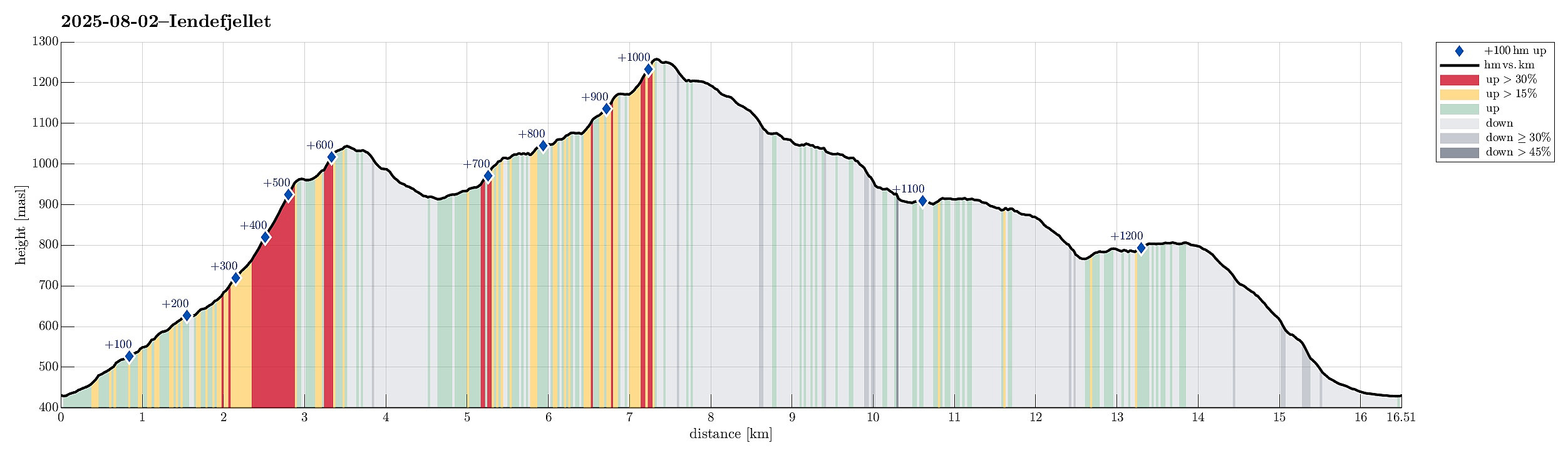 We expected "one last nice day before the rain" and thus aimed at one more nice hike! :-) Without much hesitation, we agreed to make a hike to Iendefjellet, north of Kvamskogen. We took the car from Bergen to Kvamskogen and parked at the southern end of Tryglakleiv, right next to the "main road" across Kvamskogen (road #49). We then started to hike up road Tryglakleiv, aiming at the heights in the southwest of Tryglakleivtjørnane. All of this is easy to find and from "up there" (a bit below 600 masl), the real ascent towards Byrkjefjellet starts (then mostly in northern direction). Following a proper trail, we completed the (partially steep) ascent relatively quickly. It was, however, very hot and we recognized and respected the roughly 600 height meters >>>
Livarden from Haukelandsvatnet
- Dato:
- 27.07.2025
- Turtype:
- Fottur
- Turlengde:
- 4:00t
- Distanse:
- 7,9km
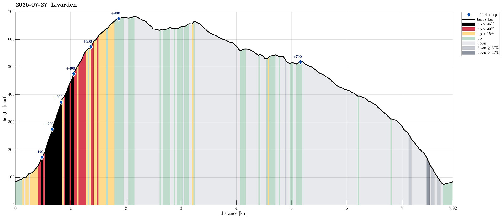 We wished to use (part of) the nice Sunday for a nice hike and chose Livarden, not far from Bergen. Instead of the usual hike (from Totland), we decided to approach it "direttissima" from Haukelandsvatnet. We parked in the southeast of Nygardsvika (langs Unnelandsvegen) and started in easterly direction -- to pass by (and below) Kalvehalsen. For a bit, we followed a (faint) trail, which leads up to a small building south (and above) Kalvehalsen. Instead of following this trail for any longer part, however, we quickly aimed at Stallafossen (there wasn't much to see or hear of this waterfall, though -- probably due to the rather dry perdiod during the past days). The goal was to ascend to a ridge in the south of Stallafossen (the first "big" one on the westside of the >>>
Exploring Suomenlinna south of Helsinki
- Dato:
- 12.07.2025
- Turtype:
- Spasertur
- Turlengde:
- 2:30t
- Distanse:
- 5,8km
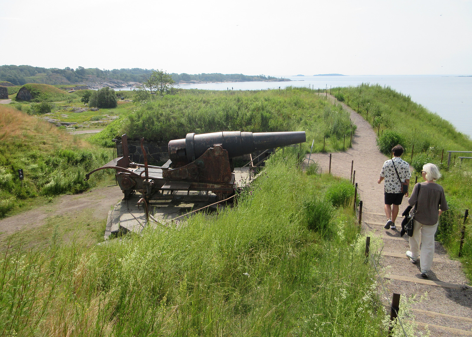 Our travel itinerary included about 24 hours in Helsinki before the follow-up flight further west. Exploiting our massive time confusion -- 6 am in Helsinki was like noon-time in Tokyo, after all -- we headed straight for the city center of Helsinki and from their, using the public ferry, to Suomenlinna, i.e., an island a bit south of the center of Helsinki, which previously was fortified massively. Today, quite a few visit this island, apparently, to see these fortifications. Before mostly following the "main-trail" across the island, we included a short detour to Pikku-Musta and Länsi-Musta, also. At the southern-most part of Suomenlinna, we then made a round around the fortifications before head back to the ferry quay where we had arrived earlier.
Selected photos are available >>>
Our travel itinerary included about 24 hours in Helsinki before the follow-up flight further west. Exploiting our massive time confusion -- 6 am in Helsinki was like noon-time in Tokyo, after all -- we headed straight for the city center of Helsinki and from their, using the public ferry, to Suomenlinna, i.e., an island a bit south of the center of Helsinki, which previously was fortified massively. Today, quite a few visit this island, apparently, to see these fortifications. Before mostly following the "main-trail" across the island, we included a short detour to Pikku-Musta and Länsi-Musta, also. At the southern-most part of Suomenlinna, we then made a round around the fortifications before head back to the ferry quay where we had arrived earlier.
Selected photos are available >>>
