Arkiv - dato
Arkiv - aktivitet
-
Annen tur (1)
- Kajakkpadling (1)
-
Annen vintertur (4)
- Trugetur (4)
- Fottur (703)
-
Skitur (3)
- Fjellskitur (3)
-
Sykkeltur (110)
- Blandet sykling (35)
- Gatesykling (5)
Arkiv - Etter geografi
"Peakbookvenner"


Lister jeg samler etter
-
Bergen ≥ 50m pf. og ≥ 100 m.o.h.
(87/89)
 97%
97% -
Most dominating tops of the Bergen peninsula
(68/75)
90%
-
Utvalgte topper og turmål i Bergen
(299/339)
88%
-
Alle topper i Bergen
(344/392)
87%
-
Opptur Bergen
(99/113)
87%
-
De syv fjell rundt Bergen
(6/7)
85%
-
Sund ≥ 50m pf.
(14/18)
77%
-
Os ≥ 50m pf.
(25/34)
73%
-
Søyler (fastmerker) i Bergen
(66/100)
66%
-
Fjell ≥ 50m pf.
(21/32)
65%

Lundåsane from Hausdalen
- Dato:
- 14.09.2025
- Turtype:
- Fottur
- Turlengde:
- 3:00t
- Distanse:
- 5,9km
 We wished to explore the Hausdalen-side of Lundåsane and thus drove to Hausdalen, where we parked a bit south of Håland. From there, we first walked up a gravel road that extends parallel to Hålandsbekken. About half way up, I decided that I wished to explore Storerinden, in the east of Slokadalen, also. Stepping up to this hill was straight-forward, while not on a trail, though. From Storerinden, while not really a prominent "peak", I still got a nice view towards Hausdalshorgi (it's always nice to see Hausdalshorgi!). I then continued across the ridge to re-connect with the gravel road near the T-junction, where one leg of the gravel road extends a bit further up to Plasset. Instead of following the gravel road any further, though, I used a trail (maybe more a former trail) >>>
Lysehornet from Kismulvegen
- Dato:
- 07.09.2025
- Turtype:
- Fjelltur
- Turlengde:
- 4:00t
- Distanse:
- 6,9km
 We had the idea to hike Lysehornet from the northeast (from Kismulvegen) and thus drove via Fana to Kalandsvatnet. Near house #47 along Kismulvegen, we parked -- not without an interaction with a man, who made it explicit that he'd wish us to park in Bygarasjen instead. We then started our hike into southwestern direction, first following a side-part of Kismulvegen up and towards Lindedalen. At large, the plan was to get to Lysehornet without a trail, while then taking a trail back down. After passing the upper houses (and quite a bit of rusting garbage of small to large sizes), we eventually made into the forest of Lindedalen. The first high point to reach was Hovåsen and the ascent from the northeast was a bit steep (but well doable). From Hovåsen, the plan was to hike around the >>>
Nonhøyen etc.
- Dato:
- 23.08.2025
- Turtype:
- Blandet sykling
- Turlengde:
- 10:00t
- Distanse:
- 94,7km
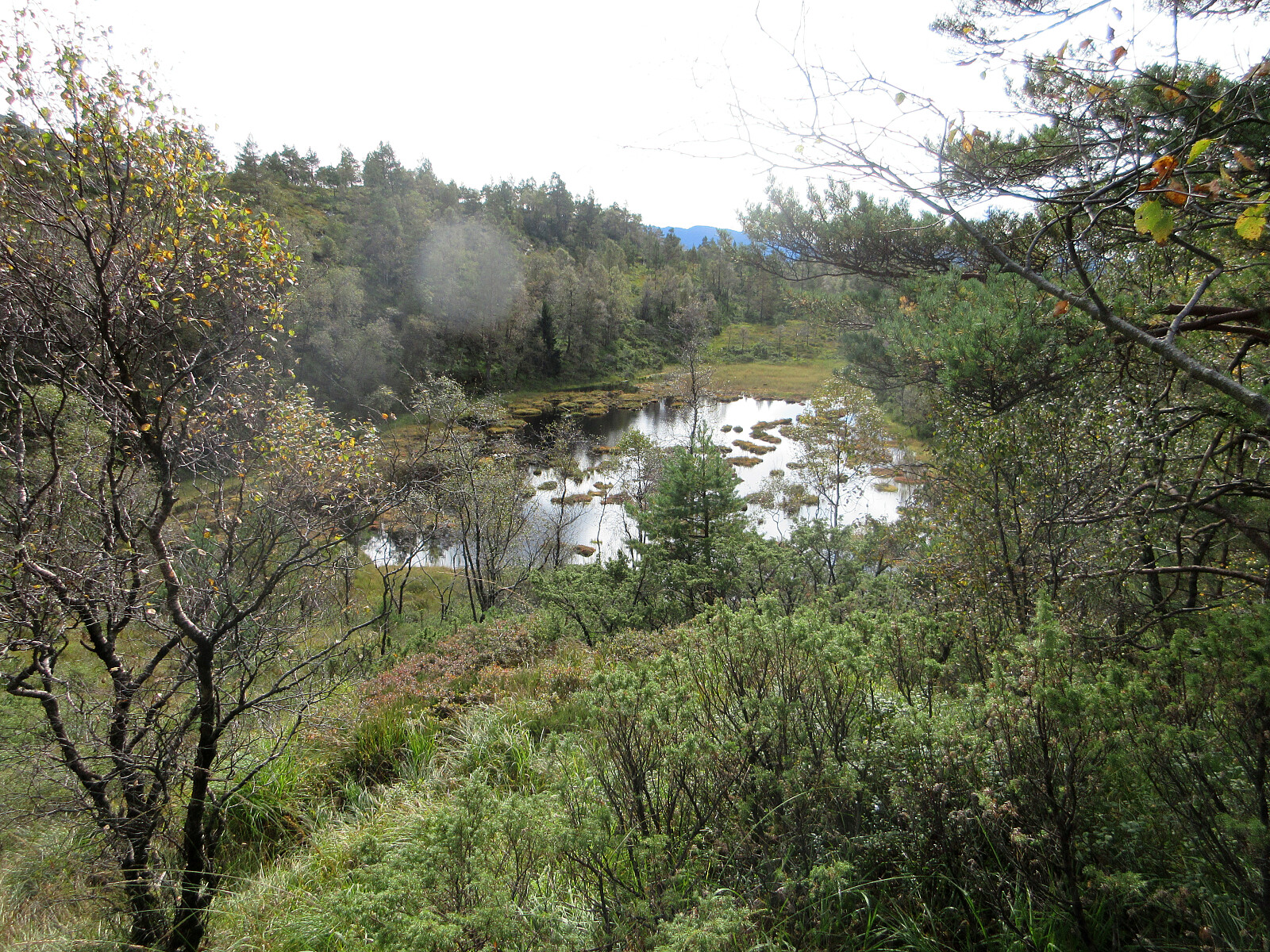
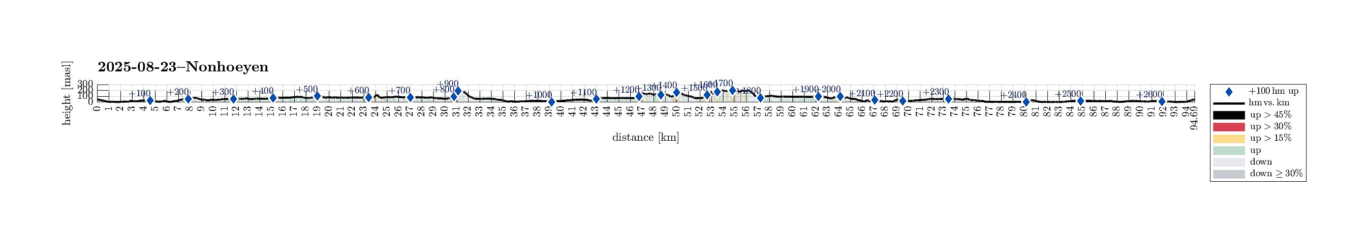 It looked like a promising Saturday and I wished to do another bike-hiking excursion to see a few places that I had not seen so far. I started by cycling via Straume to Søreide and then further into the direction of Lagunen. After cycling around Apeltunvatnet in its south, I connected to Tranevatnet and from there, after passing under E39, along Birkelandsvatnet to Dyngelandsvegen. This road brought me then to Helldal, where I eventually joined Hardangervegen to pass by Grimevatnet and then Søylevatnet. Cycling along this rather much used (and rather narrow) road is not exactly fun for the cyclist and one should only do it, when prepared for a bit of stress. Leaving Hardangervegen, I then continued along Unnelandsvegen, south of Haukelandsvatnet. At Storeklubben, I made my first short >>>
Almelandsfjellet etc.
- Dato:
- 10.08.2025
- Turtype:
- Fjelltur
- Turlengde:
- 3:00t
- Distanse:
- 6,2km
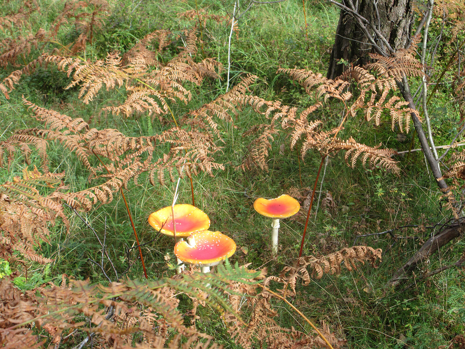
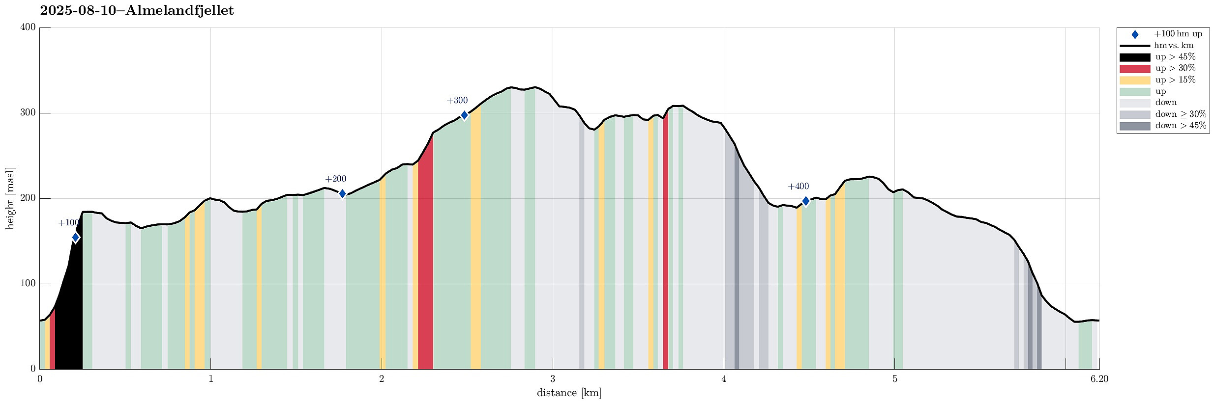 On this partially wet Sunday, the plan was to make something not too long and not too far away. Since I had not visited Smørkisfjellet before, I "cooked up" a round, starting from Osvegen near Kalandseidet. I somehow thought that I could try an ascent to Blåurskampen from the west (even though I had seen during my map study at home that this side of this hill is very steep with quite some cliffs, actually). I started from right underneath Blåurskampen and already down at Osvegen I wondered whether this really was such a good idea (it was not). I still entered the terrain and quickly found out: (a) it was wet from all the rain, (b) there was a lot of vegetation, and (c) it is truly steep -- at times way too steep there. I still continued (why?), making height meters relatively >>>
Livarden from Haukelandsvatnet
- Dato:
- 27.07.2025
- Turtype:
- Fottur
- Turlengde:
- 4:00t
- Distanse:
- 7,9km
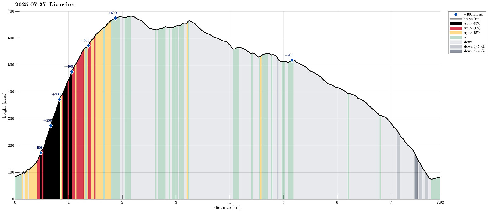 We wished to use (part of) the nice Sunday for a nice hike and chose Livarden, not far from Bergen. Instead of the usual hike (from Totland), we decided to approach it "direttissima" from Haukelandsvatnet. We parked in the southeast of Nygardsvika (langs Unnelandsvegen) and started in easterly direction -- to pass by (and below) Kalvehalsen. For a bit, we followed a (faint) trail, which leads up to a small building south (and above) Kalvehalsen. Instead of following this trail for any longer part, however, we quickly aimed at Stallafossen (there wasn't much to see or hear of this waterfall, though -- probably due to the rather dry perdiod during the past days). The goal was to ascend to a ridge in the south of Stallafossen (the first "big" one on the westside of the >>>
Steinfjellet from Osavatnet (via Vossavardane)
- Dato:
- 09.06.2025
- Turtype:
- Fottur
- Turlengde:
- 7:00t
- Distanse:
- 16,4km
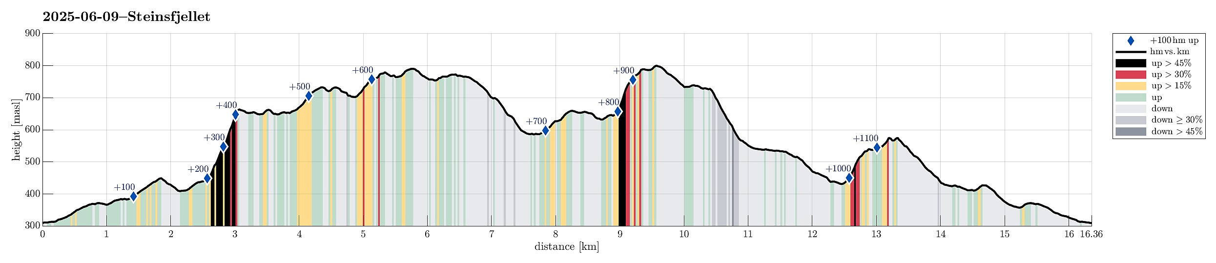 We decided to make a hike to Steinfjellet in the east of Gulltjørna. After comparing different approach options, we decided to hike Steinfjellet from Osavatnet (via Vossavardane). This gave us also the opportunity to explore the direct ascent to Vossavardane from Songstaddalen via Gasebrekkene. After parking near Osavatnet, we thus first hiked into the direction of Songstaddalen (northwest of Svartavassrinden). From Songstaddalen, we then entered the lower stretches of Gasebrekkene (steep, yes, but well doable -- without a trail, of course). Getting up to the saddle between Hotten in the south and Tjørndalsskaret in the north proved well possible, while steep as expected. The only one point to consider is that it's not all that clear how to avoid a bush war up there (possible, but one >>>
Mixed excursion to Frotveit
- Dato:
- 31.05.2025
- Turtype:
- Blandet sykling
- Turlengde:
- 5:00t
- Distanse:
- 61,0km
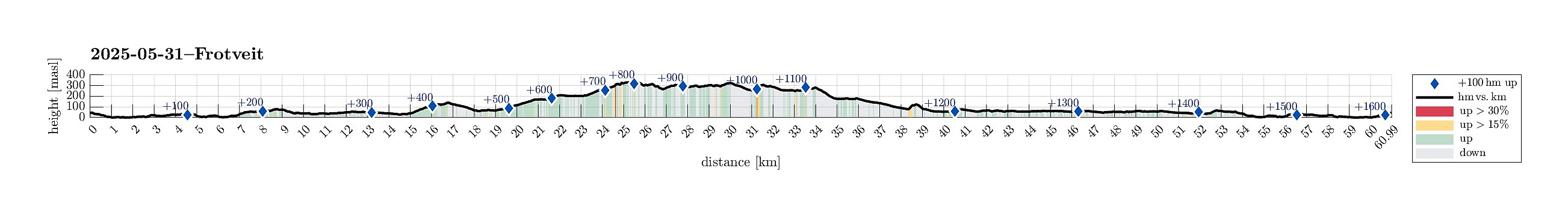 Given the nice Saturday, it was just to get some fresh air! I took my bike and started in southern direction. After passing Steinsvik, I then connected to Lagunen. My attempt to continue further towards Nesttun from there, was inhibited by some road work, making me cycle around Apeltunvatnet, instead. From Nesttun, I then connected to Øvsttun, where I explored the highest point. Thereafter, my goal was to bike up to Totland to do some more exploration. I left my bike at the parking lot at the end of Totlandsvegen and ascended to the hill in the west of it. Once up there, I decided that I could simply traverse the heights in order to get via Kollifjellet tp Ytstafjellet. After doing that, I returned via the forest road that apparently is used as a skiing track in winter. Once down to >>>
Lyderhorn
- Dato:
- 24.05.2025
- Turtype:
- Fjelltur
- Turlengde:
- 1:30t
- Distanse:
- 2,9km
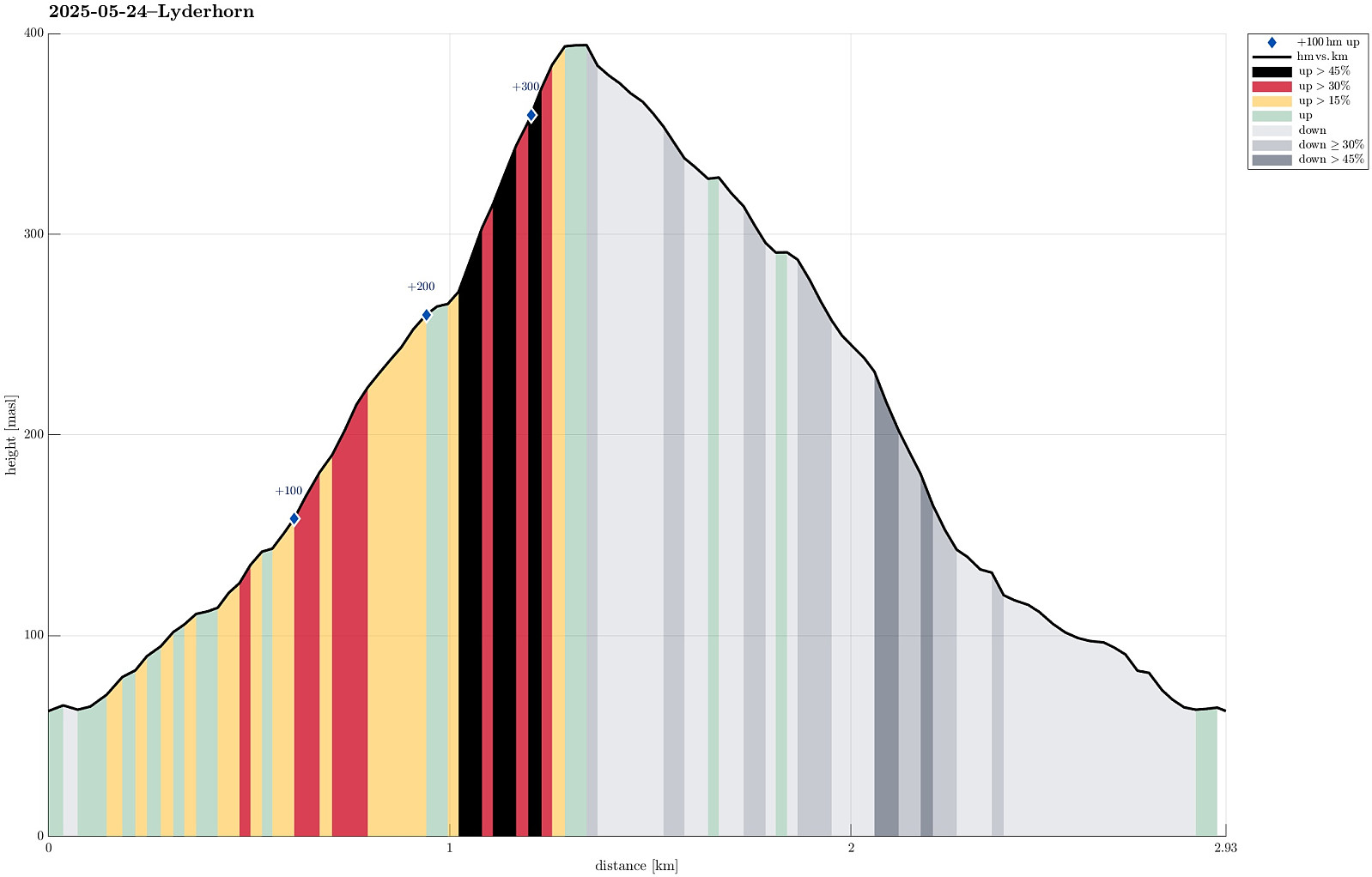 We had something like two hours available and thus aimed at "just" Lyderhorn in the neighborhood. Always nice to hike up and down this little mountain with nonetheless impressive views! :-)
Selected photos are available as Google photo album .
See also the related FB-page Hiking around Bergen, Norway .
Petter Bjørstad has a useful page about Lyderhorn and also web page WestCoastPeaks.com provides useful information about Lyderhorn and Ørnafjellet .
We had something like two hours available and thus aimed at "just" Lyderhorn in the neighborhood. Always nice to hike up and down this little mountain with nonetheless impressive views! :-)
Selected photos are available as Google photo album .
See also the related FB-page Hiking around Bergen, Norway .
Petter Bjørstad has a useful page about Lyderhorn and also web page WestCoastPeaks.com provides useful information about Lyderhorn and Ørnafjellet .
Vallaheiane via Larsaberget from Tranevatnet
- Dato:
- 11.05.2025
- Turtype:
- Blandet sykling
- Turlengde:
- 4:30t
- Distanse:
- 40,2km
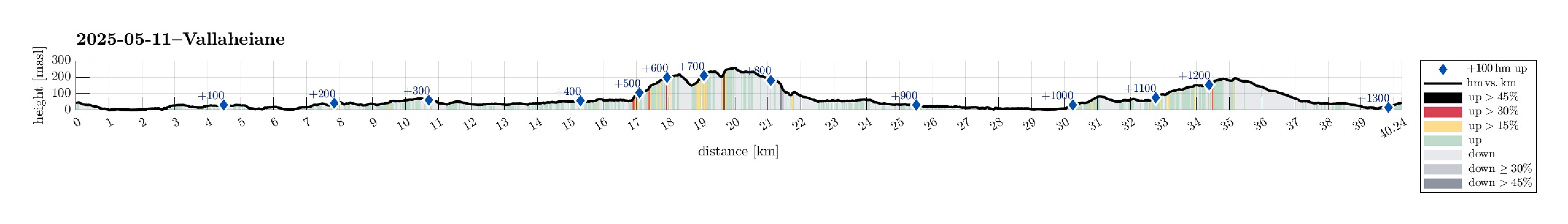 The main idea was to get some fresh air. I thus took the bike and started with the idea to explore Vallaheiane from Tranevatnet. I first biked south and crossed the partially closed off bridge at Straume. I then continued towards Steinsvik, where I left the "main road" to take a look at Ospåsen, a bit further south. The matter of fact that there's also a golf course in this area does not make getting around easier. Back on my bike, I continued, crossing over Flyplassvegen, to the sports arena next to Grimseidvegen. After a short bio-break at Lagunen, I continued around Apeltunvatnet, then to Iglavatnet, and further to Tranevatnet. I then parked my bike along the gravel road on the south side of Tranevatnet to start my exploration on foot from there. I first found a good way >>>
Herlandsfjellet via Geitaryggen
- Dato:
- 04.05.2025
- Turtype:
- Fottur
- Turlengde:
- 3:15t
- Distanse:
- 7,9km
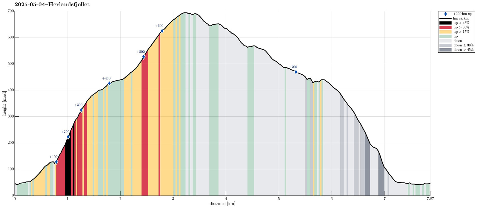 I wished to explore a new ascent route to Herlandsfjellet, as well as a new descent route, also. I drove eastwards out of Bergen to connect with E16 at Indre Arna. Right next to the large bridge to Osterøy, I parked the car and started my hike. After only walking a few meters in westerly direction, I passed a few houses at Geila in order to find a connection to Geitaryggen. Indeed, it was well possible and quite enjoyable to cross over to Tverrelva, basically following the traverse where also a water pipe is laid for the houses at Geila. Quickly, I had made it to Tverrelva and crossing over it was also no problem at all. In the southwest of Tverrelva, I then started my ascent to Geitaryggen "for real" (no trail, but very well possible to ascend via this ridge -- yes, it's a >>>
